
File:Agalega Islands map-en.svg

呢個「SVG」檔案嘅呢個「PNG」預覽嘅大細:493 × 600 像素。 第啲解像度:197 × 240 像素|394 × 480 像素|631 × 768 像素|842 × 1,024 像素|1,683 × 2,048 像素|1,500 × 1,825 像素。
原本檔案 (SVG檔案,表面大細: 1,500 × 1,825 像素,檔案大細:434 KB)
摘要
| Camera location | | View this and other nearby images on: OpenStreetMap |
|---|
| 描述 | |||
| 日期 | |||
| 來源 |
Own work
|
||
| 作者 | Eric Gaba (Sting - fr:Sting) | ||
| 許可 (重用呢個檔案) |
|
||
| Other versions |
|


|
This SVG file contains embedded text that can be translated into your language, using any capable SVG editor, text editor or the SVG Translate tool. For more information see: About translating SVG files. |
協議
I, the copyright holder of this work, hereby publish it under the following licenses:

|
根據自由軟體基金會發佈嘅無固定段落、封面文字同封底文字GNU自由文件授權條款第1.2或打後嘅版本,你獲授權可以重製、散佈同埋修改爾份文件。授權條款嘅副本喺章節GNU自由文件授權條款。 |
This file is licensed under the Creative Commons Attribution-Share Alike 4.0 International, 3.0 Unported, 2.5 Generic, 2.0 Generic and 1.0 Generic license.
- 你可以:
- 去分享 – 複製、發佈同傳播呢個作品
- 再改 – 創作演繹作品
- 要遵照下面嘅條件:
- 署名 – 你一定要畀合適嘅表彰、畀返指向呢個授權條款嘅連結,同埋寫明有無改過嚟。你可以用任何合理方式去做,但唔可以用任何方式暗示授權人認可咗你或者你嘅使用方式。
- 相同方式分享 – 如果你用任何方式改過呢個作品,你必須要用返原本或者相似嘅條款發佈。
你可以揀你想用嘅牌照。
檔案歷史
撳個日期/時間去睇響嗰個時間出現過嘅檔案。
| 日期/時間 | 縮圖 | 尺寸 | 用戶 | 註解 | |
|---|---|---|---|---|---|
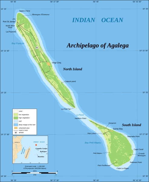
| 現時 | 2008年6月30號 (一) 13:42 | | 1,500 × 1,825(434 KB) | Sting | == Summary == {{Location|10|25|00|S|56|38|05|E|scale:200000}} <br/>{{Information |Description={{en|Map in English of the archipelago of Agalega, Mauritius.<br/> *UTM projection, WGS84 datum<br/> *Estimated scale : |
檔案用途
以下嘅1版用到呢個檔:
全域檔案使用情況
下面嘅維基都用緊呢個檔案:
- cs.wikipedia.org嘅使用情況
- de.wikipedia.org嘅使用情況
- en.wikipedia.org嘅使用情況
- gl.wikipedia.org嘅使用情況
- it.wikipedia.org嘅使用情況
- ja.wikipedia.org嘅使用情況
- ka.wikipedia.org嘅使用情況
- ko.wikipedia.org嘅使用情況
- lt.wikipedia.org嘅使用情況
- nl.wikipedia.org嘅使用情況
- pl.wikipedia.org嘅使用情況
- ro.wikipedia.org嘅使用情況
- sv.wikipedia.org嘅使用情況
- ta.wikinews.org嘅使用情況
- tr.wikipedia.org嘅使用情況
- uk.wikipedia.org嘅使用情況
- www.wikidata.org嘅使用情況
- yo.wikipedia.org嘅使用情況
- zh.wikipedia.org嘅使用情況