
File:Athanasius Kircher's Atlantis.gif
冇更高解像度嘅圖像。
Athanasius_Kircher's_Atlantis.gif (617 × 410 像素,檔案大細:36 KB ,MIME類型:image/gif)
| 描述 |
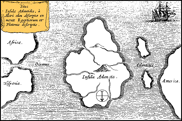
Latina: Situs Insulae Atlantidis, a mari olim absorpte ex mente Aegyptiorum et Platonis descriptio.
Русский: Карта Атлантиды Афанасия Кирхера, 1669 год. Обратите внимание, север, как показано стрелкой на карте, расположен в нижней части. |
|||||||||||||||||||||||
| 日期 | circa 1669年 | |||||||||||||||||||||||
| 來源 | https://www.haktanir.org/ | |||||||||||||||||||||||
| 作者 |
|
|||||||||||||||||||||||
| Other versions |
|
|||||||||||||||||||||||


.jpg)
|
呢個作品喺來源國同埋其他版權期限係作者過身後100年或以下嘅國家同地區屬於公有領域。 | |
| This file has been identified as being free of known restrictions under copyright law, including all related and neighboring rights. | |
檔案歷史
撳個日期/時間去睇響嗰個時間出現過嘅檔案。
| 日期/時間 | 縮圖 | 尺寸 | 用戶 | 註解 | |
|---|---|---|---|---|---|
| 現時 | 2013年10月15號 (二) 12:39 | | 617 × 410(36 KB) | AnonMoos | Reverted to version as of 01:05, 29 December 2005 -- rotating image turned text upside down |
| 2013年10月15號 (二) 12:37 |  | 617 × 410(36 KB) | Rotatebot | Bot: Image rotated by 180° | |
| 2005年12月29號 (四) 01:05 |  | 617 × 410(36 KB) | Comae | Tomado de en.wikipedia, donde dice: Author: Athanasius_Kircher's Map of Atlantis (c.1669) Source: http://atlants.haktanir.org/ch3.html This image is in the public domain because its copyright has expired in the United States and those countries with a c |
檔案用途
以下嘅1版用到呢個檔:
全域檔案使用情況
下面嘅維基都用緊呢個檔案:
- af.wikipedia.org嘅使用情況
- an.wikipedia.org嘅使用情況
- ar.wikipedia.org嘅使用情況
- ar.wikiversity.org嘅使用情況
- ast.wikipedia.org嘅使用情況
- az.wikipedia.org嘅使用情況
- be-tarask.wikipedia.org嘅使用情況
- beta.wikiversity.org嘅使用情況
- be.wikipedia.org嘅使用情況
- bg.wikipedia.org嘅使用情況
- bn.wikipedia.org嘅使用情況
- ca.wikipedia.org嘅使用情況
- ceb.wikipedia.org嘅使用情況
- cs.wikipedia.org嘅使用情況
- de.wikipedia.org嘅使用情況
- diq.wikipedia.org嘅使用情況
- el.wikipedia.org嘅使用情況
- en.wikipedia.org嘅使用情況
- en.wikibooks.org嘅使用情況
- en.wikiversity.org嘅使用情況
- en.wikivoyage.org嘅使用情況
- eo.wikipedia.org嘅使用情況
- es.wikipedia.org嘅使用情況
- es.wikibooks.org嘅使用情況
- et.wikipedia.org嘅使用情況
- eu.wikipedia.org嘅使用情況
- fi.wikibooks.org嘅使用情況
- fr.wiktionary.org嘅使用情況
- fy.wikipedia.org嘅使用情況
睇呢個檔案嘅更多全域使用情況。