
File:Bản đồ Hà Nội.png
原本檔案 (3,000 × 2,996 像素,檔案大細:3.46 MB ,MIME類型:image/png)
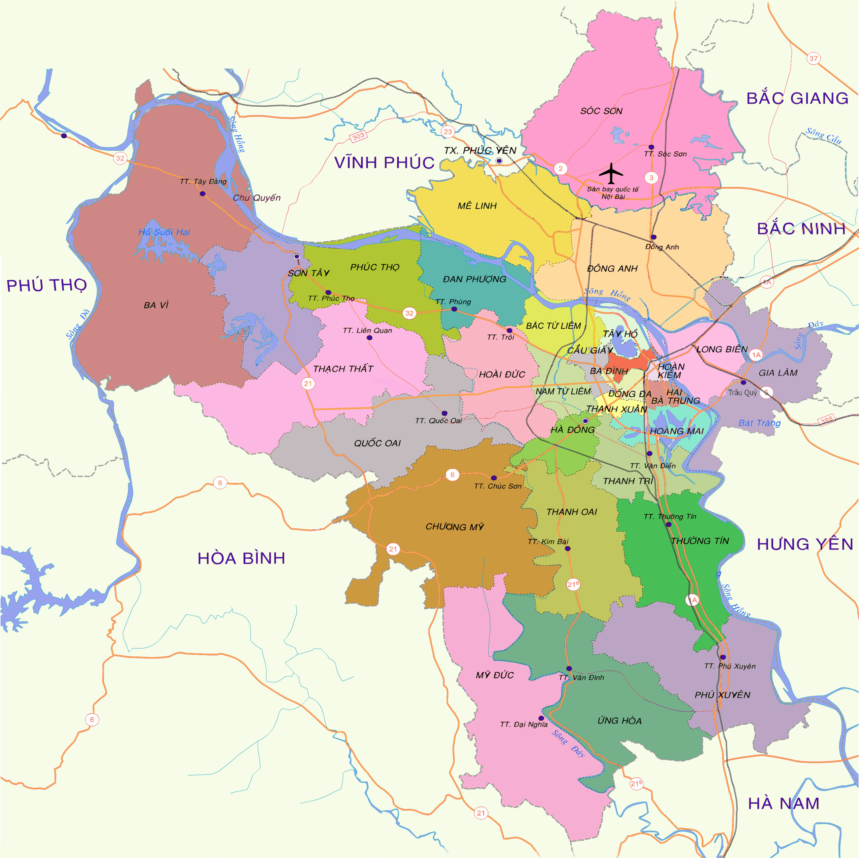
| 描述 |
English: Map of Hanoi at the end of 2008
Tiếng Việt: Bản đồ Hà Nội cuối năm 2008 |
| 日期 | 15:19, ngày 30 tháng 12 năm 2008 (UTC) |
| 來源 | vi:Tập tin:Bản đồ Hà Nội.png |
| 作者 | Lưu Ly |
| 許可 (重用呢個檔案) |
Ĉi tiu dosiero estas disponebla laŭ la permesilo Krea Komunaĵo Atribuite 3.0 Neadaptita.
|
| Other versions | vi:Tập tin:Bản đồ Hà Nội (tạm).png |

.png)
| Annotations | This image is annotated: View the annotations at Commons |
| Camera location | | View this and other nearby images on: OpenStreetMap |
|---|
檔案歷史
撳個日期/時間去睇響嗰個時間出現過嘅檔案。
| 日期/時間 | 縮圖 | 尺寸 | 用戶 | 註解 | |
|---|---|---|---|---|---|
| 現時 | 2013年12月27號 (五) 16:52 | | 3,000 × 2,996(3.46 MB) | Tran The Vinh | chia đơn vị hành chính |
| 2009年3月27號 (五) 09:31 |  | 2,976 × 2,972(2.31 MB) | Newone | {{Information |Description={{en|1=Map of Hanoi at the end of 2008}} {{vi|1=Bản đồ Hà Nội cuối năm 2008}} |Source=vi:Tập tin:Bản đồ Hà Nội.png |Author=Lưu Ly |Date=15:19, ngày 30 tháng 12 năm 2008 |
檔案用途
以下嘅1版用到呢個檔:
全域檔案使用情況
下面嘅維基都用緊呢個檔案:
- arz.wikipedia.org嘅使用情況
- bat-smg.wikipedia.org嘅使用情況
- ba.wikipedia.org嘅使用情況
- bcl.wikipedia.org嘅使用情況
- be-tarask.wikipedia.org嘅使用情況
- beta.wikiversity.org嘅使用情況
- bxr.wikipedia.org嘅使用情況
- ca.wikipedia.org嘅使用情況
- ceb.wikipedia.org嘅使用情況
- cs.wikipedia.org嘅使用情況
- cv.wikipedia.org嘅使用情況
- da.wikisource.org嘅使用情況
- de.wikipedia.org嘅使用情況
- de.wikisource.org嘅使用情況
- de.wikiversity.org嘅使用情況
- en.wikipedia.org嘅使用情況
- en.wikisource.org嘅使用情況
- en.wikivoyage.org嘅使用情況
- eo.wikipedia.org嘅使用情況
- es.wikipedia.org嘅使用情況
- es.wikibooks.org嘅使用情況
- es.wikinews.org嘅使用情況
- es.wikisource.org嘅使用情況
- fiu-vro.wikipedia.org嘅使用情況
- fi.wiktionary.org嘅使用情況
- frr.wikipedia.org嘅使用情況
- fr.wikipedia.org嘅使用情況
- fr.wikibooks.org嘅使用情況
- fr.wikinews.org嘅使用情況
- fr.wikiquote.org嘅使用情況
- fr.wikisource.org嘅使用情況
- fr.wikiversity.org嘅使用情況
- fr.wiktionary.org嘅使用情況
- fy.wikipedia.org嘅使用情況
- ga.wikipedia.org嘅使用情況
- gl.wikipedia.org嘅使用情況
- gu.wikipedia.org嘅使用情況
- gv.wikipedia.org嘅使用情況
- haw.wikipedia.org嘅使用情況
睇呢個檔案嘅更多全域使用情況。