
File:Baltic Sea map.png
原本檔案 (1,493 × 1,598 像素,檔案大細:655 KB ,MIME類型:image/png)
摘要
| 描述 |
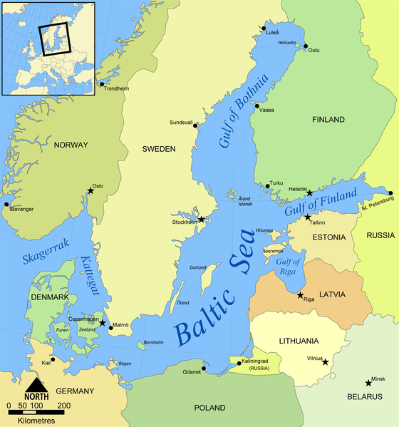
English: Map of the Baltic Sea. |
| 日期 | |
| 來源 | 自己作品 (Created by NormanEinstein) |
| 作者 | NormanEinstein |
| Other versions |
[]
|


協議
NormanEinstein, the copyright holder of this work, hereby publishes it under the following license:

|
根據自由軟體基金會發佈嘅無固定段落、封面文字同封底文字GNU自由文件授權條款第1.2或打後嘅版本,你獲授權可以重製、散佈同埋修改爾份文件。授權條款嘅副本喺章節GNU自由文件授權條款。 |
| 呢個檔案用共享創意 姓名標示-非商業性-相同方式分享3.0 未本地化版本條款授權。 | ||
| 姓名標示: NormanEinstein | ||
| ||
| This licensing tag was added to this file as part of the GFDL licensing update. |
Derivative works
Derivative works of this file:
- Baltic Sea map-sv.png
- Baltic Sea map2.png
- Baltic Sea map3.png
- Baltic Sea map hr.svg
- Baltic Sea map2 hr.svg
- Mar Baltico mappa.jpg
- Baltic Sea map Urdu.svg
- Baltic Sea map Usedom location.png
- Baltic Sea map cy PNG.png
檔案歷史
撳個日期/時間去睇響嗰個時間出現過嘅檔案。
| 日期/時間 | 縮圖 | 尺寸 | 用戶 | 註解 | |
|---|---|---|---|---|---|
| 現時 | 2022年6月6號 (一) 12:45 |  | 1,493 × 1,598(655 KB) | 野良人 | opt |
| 2012年5月7號 (一) 12:33 |  | 1,493 × 1,598(672 KB) | Ras67 | cropped, opt. | |
| 2008年10月1號 (三) 12:04 |  | 1,500 × 1,606(804 KB) | Salleman~commonswiki | added dots to Malmö and a ring to Luleå as per Åland, Öland and Rügen having their diacritics | |
| 2006年5月25號 (四) 15:47 |  | 1,500 × 1,606(803 KB) | NormanEinstein | Map of the Baltic Sea. Created by NormanEinstein, May 25, 2006. {{GFDL-self}} Category:Maps of seas |
檔案用途
以下嘅1版用到呢個檔:
全域檔案使用情況
下面嘅維基都用緊呢個檔案:
- af.wikipedia.org嘅使用情況
- am.wikipedia.org嘅使用情況
- anp.wikipedia.org嘅使用情況
- an.wikipedia.org嘅使用情況
- ar.wikipedia.org嘅使用情況
- ast.wikipedia.org嘅使用情況
- as.wikipedia.org嘅使用情況
- awa.wikipedia.org嘅使用情況
- azb.wikipedia.org嘅使用情況
- az.wiktionary.org嘅使用情況
- ban.wikipedia.org嘅使用情況
- ba.wikipedia.org嘅使用情況
- bg.wikipedia.org嘅使用情況
- bh.wikipedia.org嘅使用情況
- bn.wikipedia.org嘅使用情況
- bs.wikipedia.org嘅使用情況
- ca.wikipedia.org嘅使用情況
- ckb.wikipedia.org嘅使用情況
- crh.wikipedia.org嘅使用情況
- cs.wikipedia.org嘅使用情況
- cv.wikipedia.org嘅使用情況
- cy.wikipedia.org嘅使用情況
- da.wikipedia.org嘅使用情況
- dsb.wikipedia.org嘅使用情況
- el.wikipedia.org嘅使用情況
- el.wiktionary.org嘅使用情況
- en.wikipedia.org嘅使用情況
- Lockheed SR-71 Blackbird
- Gulf of Bothnia
- Baltic region
- Category:Baltic Sea
- User:NormanEinstein/gallery
- Wikipedia:Userboxes/Location
- Portal:Estonia/Featured article/2006 archive
- Portal:Estonia/Featured article/August 2006
- User:Buaidh
- Wikipedia:Userboxes/Travel
- Portal:Estonia/Selected article
- Portal:Estonia/Selected article/2
- Ocean fisheries
- Category:Fish of the Baltic Sea
睇呢個檔案嘅更多全域使用情況。