
File:Barents Sea map.png
預覽大細:657 × 600 像素。 第啲解像度:263 × 240 像素|526 × 480 像素|841 × 768 像素|1,187 × 1,084 像素。
原本檔案 (1,187 × 1,084 像素,檔案大細:654 KB ,MIME類型:image/png)
摘要
| 描述 |
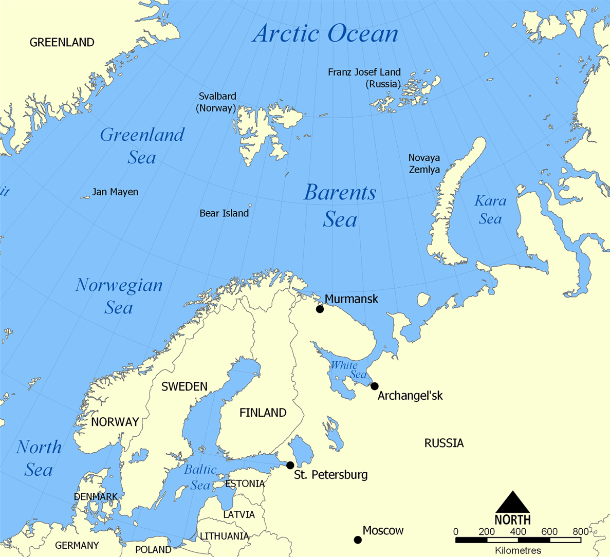
English: The location of the Barents Sea north of Russia and Norway, and the surrounding seas and islands. Also includes political borders with their corresponding nation-states listed. |
| 日期 | |
| 來源 | 自己作品 |
| 作者 | NormanEinstein |
| Other versions |
[]
|


協議
I, the copyright holder of this work, hereby publish it under the following licenses:

|
根據自由軟體基金會發佈嘅無固定段落、封面文字同封底文字GNU自由文件授權條款第1.2或打後嘅版本,你獲授權可以重製、散佈同埋修改爾份文件。授權條款嘅副本喺章節GNU自由文件授權條款。 |
| 呢個檔案用共享創意 姓名標示-非商業性-相同方式分享3.0 未本地化版本條款授權。 | ||
| ||
| This licensing tag was added to this file as part of the GFDL licensing update. |
你可以揀你想用嘅牌照。
檔案歷史
撳個日期/時間去睇響嗰個時間出現過嘅檔案。
| 日期/時間 | 縮圖 | 尺寸 | 用戶 | 註解 | |
|---|---|---|---|---|---|
| 現時 | 2012年3月29號 (四) 20:52 | | 1,187 × 1,084(654 KB) | Ras67 | cropped |
| 2006年2月5號 (日) 06:11 |  | 1,200 × 1,098(680 KB) | Berkut~commonswiki | pngout-ed (13% file size reduction) | |
| 2005年11月25號 (五) 16:40 |  | 1,200 × 1,098(781 KB) | NormanEinstein | This map shows the location of the Barents Sea north of Russia and Norway, and the surrounding seas and islands. Created by NormanEinstein, November 25, 2005. {{GFDL-self}} Category:Maps of seas |
檔案用途
以下嘅1版用到呢個檔:
全域檔案使用情況
下面嘅維基都用緊呢個檔案:
- af.wikipedia.org嘅使用情況
- ar.wikipedia.org嘅使用情況
- arz.wikipedia.org嘅使用情況
- ast.wikipedia.org嘅使用情況
- azb.wikipedia.org嘅使用情況
- bcl.wikipedia.org嘅使用情況
- be-tarask.wikipedia.org嘅使用情況
- bg.wikipedia.org嘅使用情況
- bn.wikipedia.org嘅使用情況
- bs.wikipedia.org嘅使用情況
- ca.wikipedia.org嘅使用情況
- cs.wikipedia.org嘅使用情況
- cs.wikinews.org嘅使用情況
- da.wikipedia.org嘅使用情況
- de.wiktionary.org嘅使用情況
- el.wikipedia.org嘅使用情況
- en.wikipedia.org嘅使用情況
- Barents Sea
- User:NormanEinstein/gallery
- Keith Jessop
- Convoy PQ 18
- Fishing industry in Russia
- Operation Fritham
- List of Russian explorers
- Convoy PQ 8
- Arctic naval operations of World War II
- Convoy QP 14
- List of oil and gas fields of the Barents Sea
- Operation Orator
- Operation Gearbox
- Operation Gearbox II
- Atlantification of the Arctic
- en.wikisource.org嘅使用情況
- en.wiktionary.org嘅使用情況
- eo.wikipedia.org嘅使用情況
- es.wikipedia.org嘅使用情況
- eu.wikipedia.org嘅使用情況
- fa.wikipedia.org嘅使用情況
- fi.wikipedia.org嘅使用情況
- fo.wikipedia.org嘅使用情況
- fr.wikipedia.org嘅使用情況
- fr.wikinews.org嘅使用情況
- he.wikipedia.org嘅使用情況
- hi.wikipedia.org嘅使用情況
- hu.wiktionary.org嘅使用情況
- hy.wikipedia.org嘅使用情況
睇呢個檔案嘅更多全域使用情況。