
File:British Columbia-map.png
冇更高解像度嘅圖像。
British_Columbia-map.png (280 × 230 像素,檔案大細:14 KB ,MIME類型:image/png)

|
File:British Columbia, Canada.svg is a vector version of this file. It should be used in place of this PNG file when not inferior.
File:British Columbia-map.png → File:British Columbia, Canada.svg
For more information, see Help:SVG. |
 |
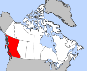
Map of British Columbia
Projection: Lambert azimuthal equal-area
Geospatial data from: The Atlas of Canada, The National Atlas of the United States archive copy at the Wayback Machine and U.S. Geological Survey
Cartographer: John Fowler
| I, the copyright holder of this work, release this work into the public domain. This applies worldwide. In some countries this may not be legally possible; if so: I grant anyone the right to use this work for any purpose, without any conditions, unless such conditions are required by law. |
檔案歷史
撳個日期/時間去睇響嗰個時間出現過嘅檔案。
| 日期/時間 | 縮圖 | 尺寸 | 用戶 | 註解 | |
|---|---|---|---|---|---|
| 現時 | 2005年3月24號 (四) 12:12 | | 280 × 230(14 KB) | Voyager | Map of British Columbia Projection: Lambert azimuthal equal-area Geospatial data from: [http://atlas.gc.ca/ The Atlas of Canada], [http://www.nationalatlas.gov/ The National Atlas of the United States] and [http://www.usgs.gov U.S. Geological Survey] C |
檔案用途
無嘢連來呢份檔案。
全域檔案使用情況
下面嘅維基都用緊呢個檔案:
- fr.wikipedia.org嘅使用情況
- he.wikivoyage.org嘅使用情況