
File:China-Heilongjiang.png
冇更高解像度嘅圖像。
China-Heilongjiang.png (268 × 218 像素,檔案大細:31 KB ,MIME類型:image/png)

|
File:China Heilongjiang.svg is a vector version of this file. It should be used in place of this PNG file when not inferior.
File:China-Heilongjiang.png → File:China Heilongjiang.svg
For more information, see Help:SVG. |
 |
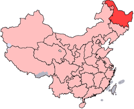
en: Location of Heilongjiang Province in the People's Republic of China. See Locator maps of province-level divisions of the People's Republic of China for more information. The striped area is administered by Daxing'anling Prefecture of Heilongjiang, but it is nominally part of Inner Mongolia Autonomous Region.
zh: 黑龍江省在中華人民共和國的位置。另見Locator maps of province-level divisions of the People's Republic of China。加斜杠的地區由黑龍江省大興安嶺地區所管轄,但在名義上為内蒙古自治區的一部分。

|
根據自由軟體基金會發佈嘅無固定段落、封面文字同封底文字GNU自由文件授權條款第1.2或打後嘅版本,你獲授權可以重製、散佈同埋修改爾份文件。授權條款嘅副本喺章節GNU自由文件授權條款。 |
| 呢個檔案用共享創意 姓名標示-非商業性-相同方式分享3.0 未本地化版本條款授權。 | ||
| ||
| This licensing tag was added to this file as part of the GFDL licensing update. |
檔案歷史
撳個日期/時間去睇響嗰個時間出現過嘅檔案。
| 日期/時間 | 縮圖 | 尺寸 | 用戶 | 註解 | |
|---|---|---|---|---|---|
| 現時 | 2007年10月28號 (日) 14:45 | | 268 × 218(31 KB) | Croquant | transparent background |
| 2005年6月4號 (六) 21:47 |  | 268 × 218(9 KB) | Ran | '''en''': Location of Heilongjiang Province in the People's Republic of China. See Category:Locator maps of province-level divisions of the People's Republic of China for more information. The striped area is administered by Daxing'anling Prefecture |
檔案用途
以下嘅40版用到呢個檔:
全域檔案使用情況
下面嘅維基都用緊呢個檔案:
- cy.wikipedia.org嘅使用情況
- da.wikipedia.org嘅使用情況
- de.wikipedia.org嘅使用情況
- en.wikipedia.org嘅使用情況
- Pingfang, Harbin
- Wikipedia:WikiProject Chinese provinces/Locator maps
- Songjiang Province
- Longjiang County
- Jingpo Lake
- Wanda Mountains
- Mingshui County
- Heitai
- Kedong County
- Bei'an
- Nan'gang, Harbin
- Yabuli Ski Resort
- Ang'angxi District
- Diaoshuilou Falls
- Mudan River
- Zhalong Nature Reserve
- Nenjiang Province
- Gannan County
- Nehe
- Shuangcheng, Harbin
- Tangchi, Heilongjiang
- Tieli
- Mishan
- Baoquan, Heilongjiang
- Heihe Aihui Airport
- Yi'an Town, Heilongjiang
- Laha, Heilongjiang
- Muling
- Template:Heilongjiang-geo-stub
- Daxing'anling Prefecture
- Daoli, Harbin
- HLA-B67
- HLA-B59
睇呢個檔案嘅更多全域使用情況。