
File:China Shanxi Taiyuan.svg

呢個「SVG」檔案嘅呢個「PNG」預覽嘅大細:705 × 599 像素。 第啲解像度:282 × 240 像素|565 × 480 像素|904 × 768 像素|1,205 × 1,024 像素|2,409 × 2,048 像素|1,000 × 850 像素。
原本檔案 (SVG檔案,表面大細: 1,000 × 850 像素,檔案大細:217 KB)
| 描述 |
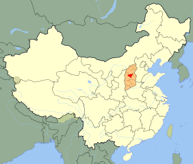
An SVG map of China with Shanxi province highlighted in orange and Taiyuan prefecture highlighted in red Legend: |
||
| 日期 | |||
| 來源 |
self-made; based on CIA public domain maps:
and Wikimedia Commons work: |
||
| 作者 | Joowwww | ||
| 許可 (重用呢個檔案) |
|
||
| Other versions |
|
||
| SVG genesis |


.png)
檔案歷史
撳個日期/時間去睇響嗰個時間出現過嘅檔案。
| 日期/時間 | 縮圖 | 尺寸 | 用戶 | 註解 | |
|---|---|---|---|---|---|
| 現時 | 2010年2月5號 (五) 22:41 | | 1,000 × 850(217 KB) | Joowwww | finalise |
| 2010年2月5號 (五) 13:31 |  | 1,000 × 850(216 KB) | Joowwww | would probably work if I saved the file first | |
| 2010年2月5號 (五) 13:30 |  | 1,000 × 850(216 KB) | Joowwww | thinner brown prefecture borders | |
| 2010年2月5號 (五) 13:27 |  | 1,000 × 850(216 KB) | Joowwww | {{Information |Description=An SVG map of China with Shanxi province highlighted in orange and Taiyuan prefecture highlighted in red Legend:<br />File:China map legend.png |Source=self-made; based on CIA public domain maps: *http://www.lib.utexas.edu |
檔案用途
以下嘅1版用到呢個檔:
全域檔案使用情況
下面嘅維基都用緊呢個檔案:
- af.wikipedia.org嘅使用情況
- ar.wikipedia.org嘅使用情況
- arz.wikipedia.org嘅使用情況
- ast.wikipedia.org嘅使用情況
- bn.wikipedia.org嘅使用情況
- bxr.wikipedia.org嘅使用情況
- ca.wikipedia.org嘅使用情況
- cdo.wikipedia.org嘅使用情況
- ce.wikipedia.org嘅使用情況
- de.wikipedia.org嘅使用情況
- el.wikipedia.org嘅使用情況
- en.wikipedia.org嘅使用情況
- eo.wikipedia.org嘅使用情況
- es.wikipedia.org嘅使用情況
- eu.wikipedia.org嘅使用情況
- fi.wikipedia.org嘅使用情況
- fr.wikipedia.org嘅使用情況
- gl.wikipedia.org嘅使用情況
- id.wikipedia.org嘅使用情況
- is.wikipedia.org嘅使用情況
- it.wikipedia.org嘅使用情況
- ja.wikipedia.org嘅使用情況
- kg.wikipedia.org嘅使用情況
- la.wikipedia.org嘅使用情況
- mn.wikipedia.org嘅使用情況
- mr.wikipedia.org嘅使用情況
- pt.wikipedia.org嘅使用情況
- ro.wikipedia.org嘅使用情況
- ru.wikipedia.org嘅使用情況
- sco.wikipedia.org嘅使用情況
- ug.wikipedia.org嘅使用情況
- uk.wikipedia.org嘅使用情況
- ur.wikipedia.org嘅使用情況
睇呢個檔案嘅更多全域使用情況。