
File:Dongtingriversmap.png

預覽大細:690 × 599 像素。 第啲解像度:276 × 240 像素|553 × 480 像素|885 × 768 像素|1,200 × 1,042 像素。
原本檔案 (1,200 × 1,042 像素,檔案大細:488 KB ,MIME類型:image/png)

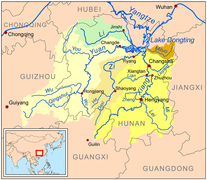
| 描述 | This is a map of the major rivers flowing into Lake Dongting; the Xiang, Zi, Yuan, Li and Miluo rivers. |
| 日期 | |
| 來源 | Own work using Digital Chart of the World and GTOPO data. |
| 作者 | Kmusser |
我,呢份作品嘅作者,決定用以下許可發佈呢件作品:
呢個檔案用共享創意 姓名標示-非商業性-相同方式分享3.0 未本地化版本條款授權。
- 你可以:
- 去分享 – 複製、發佈同傳播呢個作品
- 再改 – 創作演繹作品
- 要遵照下面嘅條件:
- 署名 – 你一定要畀合適嘅表彰、畀返指向呢個授權條款嘅連結,同埋寫明有無改過嚟。你可以用任何合理方式去做,但唔可以用任何方式暗示授權人認可咗你或者你嘅使用方式。
- 相同方式分享 – 如果你用任何方式改過呢個作品,你必須要用返原本或者相似嘅條款發佈。
檔案歷史
撳個日期/時間去睇響嗰個時間出現過嘅檔案。
| 日期/時間 | 縮圖 | 尺寸 | 用戶 | 註解 | |
|---|---|---|---|---|---|
| 現時 | 2024年1月4號 (四) 14:34 | | 1,200 × 1,042(488 KB) | Kmusser | Xiao Liuyang label fix |
| 2009年3月13號 (五) 00:06 |  | 1,200 × 1,042(610 KB) | Kmusser | spelling fix | |
| 2009年3月12號 (四) 21:07 |  | 1,200 × 1,042(611 KB) | Kmusser | {{Information |Description=This is a map of the major rivers flowing into Lake Dongting; the Xiang, Zi, Yuan, Li and Miluo rivers. |So |
檔案用途
全域檔案使用情況
下面嘅維基都用緊呢個檔案:
- af.wikipedia.org嘅使用情況
- arz.wikipedia.org嘅使用情況
- ast.wikipedia.org嘅使用情況
- bg.wikipedia.org嘅使用情況
- bn.wikipedia.org嘅使用情況
- bo.wikipedia.org嘅使用情況
- bs.wikipedia.org嘅使用情況
- ceb.wikipedia.org嘅使用情況
- cs.wikipedia.org嘅使用情況
- cy.wikipedia.org嘅使用情況
- da.wikipedia.org嘅使用情況
- de.wikipedia.org嘅使用情況
- en.wikipedia.org嘅使用情況
- eo.wikipedia.org嘅使用情況
- es.wikipedia.org嘅使用情況
- eu.wikipedia.org嘅使用情況
- fa.wikipedia.org嘅使用情況
睇呢個檔案嘅更多全域使用情況。