
File:FutureMTRNetworkAfterMerger.png
原本檔案 (5,315 × 3,543 像素,檔案大細:1.3 MB ,MIME類型:image/png)
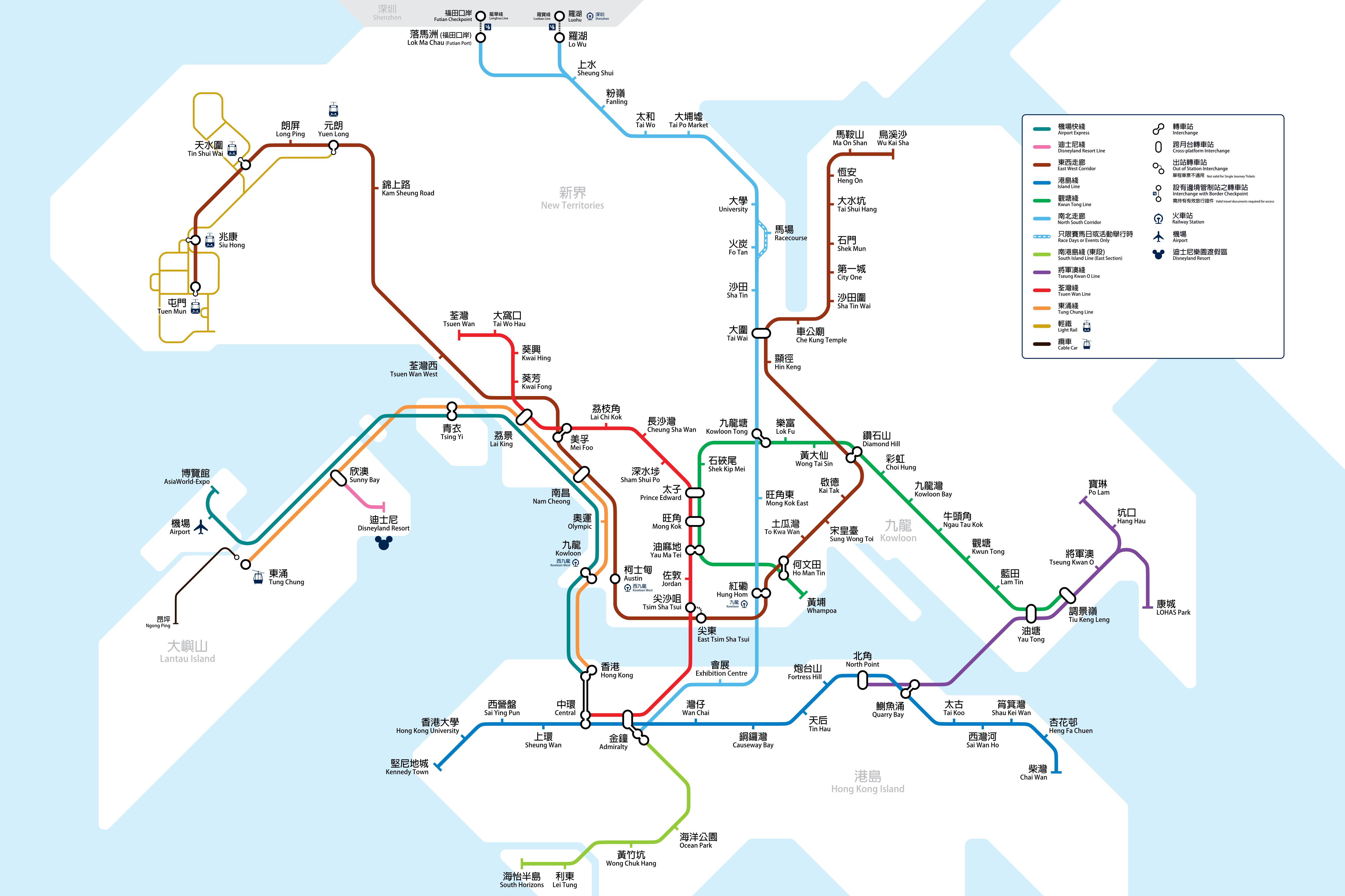
| 描述 |
 English: This map is not maintained as many of the proposed projects have been completed. Please click the thumbnail on the right from now on.
中文:因應大部份鐵路計劃已完成,本圖將不會獲得更新。請點撃右面縮圖瀏覽最新的路線圖。 |
||
| 日期 | Same as upload date | ||
| 來源 | Self-drawn | ||
| 作者 | Xavier Fung | ||
| 許可 (重用呢個檔案) |
I, the copyright holder of this work, hereby publish it under the following licenses:
This file is licensed under the Creative Commons Attribution-Share Alike 3.0 Unported, 2.5 Generic, 2.0 Generic and 1.0 Generic license.
你可以揀你想用嘅牌照。 |


|
This rail transport map image could be recreated using vector graphics as an SVG file. This has several advantages; see Commons:Media for cleanup for more information. If an SVG form of this image is already available, please upload it. After uploading an SVG, replace this template with {{vector version available|new image name.svg}}.
|
檔案歷史
撳個日期/時間去睇響嗰個時間出現過嘅檔案。
| 日期/時間 | 縮圖 | 尺寸 | 用戶 | 註解 | |
|---|---|---|---|---|---|
| 現時 | 2017年11月28號 (二) 04:50 | | 5,315 × 3,543(1.3 MB) | Xavier114fch | Exhibition > Exhibition Centre |
| 2017年11月27號 (一) 12:24 |  | 5,315 × 3,543(1.3 MB) | Xavier114fch | Name change of Sung Wong Toi and To Kwa Wan stations | |
| 2013年11月7號 (四) 15:33 |  | 5,315 × 3,543(1.87 MB) | Xavier114fch | Wrong file with MTR logo - now removed. | |
| 2013年11月7號 (四) 15:26 |  | 5,315 × 3,543(1.95 MB) | Xavier114fch | Hong Kong University -> HKU | |
| 2013年9月3號 (二) 05:48 |  | 5,315 × 3,543(1.3 MB) | Xavier114fch | New Design - Just showing the network up to year 2020. Further projects considered under RDS-2U will be presented by another map. | |
| 2012年7月28號 (六) 12:42 |  | 2,480 × 3,336(1.2 MB) | 寿司猫 | A little change | |
| 2012年7月22號 (日) 10:23 |  | 2,480 × 3,336(1.2 MB) | 寿司猫 | Some stations on Northern Link have been cancelled. | |
| 2011年11月11號 (五) 17:02 |  | 2,480 × 3,336(1.19 MB) | Xavier114fch | Update finished date of SCL. Include Kai Tak Monorail and related drawing changes. Align SIL(E) Ocean Park section better in terms of geographical layout. | |
| 2010年11月5號 (五) 06:03 |  | 2,480 × 3,336(1.16 MB) | Xavier114fch | Update SIL(E) line color to lime as illustrated by the route map displayed during ADM expansion press conference. Change SIL(W) line color to match one displayed in 2010 MTR Annual Report. | |
| 2010年10月30號 (六) 02:05 |  | 2,480 × 3,336(1.17 MB) | Xavier114fch | The opening of the SCL has been pushed backwards to 2017 for EWL and 2021 for NSL. |
檔案用途
無嘢連來呢份檔案。
全域檔案使用情況
下面嘅維基都用緊呢個檔案:
- de.wikipedia.org嘅使用情況
- el.wikipedia.org嘅使用情況
- en.wikipedia.org嘅使用情況
- fa.wikipedia.org嘅使用情況
- hak.wikipedia.org嘅使用情況
- he.wikipedia.org嘅使用情況
- id.wikipedia.org嘅使用情況
- ja.wikipedia.org嘅使用情況
- ko.wikipedia.org嘅使用情況
- nl.wikipedia.org嘅使用情況
- ru.wikipedia.org嘅使用情況
- simple.wikipedia.org嘅使用情況
- ta.wikipedia.org嘅使用情況
- uz.wikipedia.org嘅使用情況
- xmf.wikipedia.org嘅使用情況
- zh-min-nan.wikipedia.org嘅使用情況
- zh.wikipedia.org嘅使用情況