
File:Gegharkunik.svg

呢個「SVG」檔案嘅呢個「PNG」預覽嘅大細:587 × 599 像素。 第啲解像度:235 × 240 像素|470 × 480 像素|752 × 768 像素|1,003 × 1,024 像素|2,006 × 2,048 像素|725 × 740 像素。
原本檔案 (SVG檔案,表面大細: 725 × 740 像素,檔案大細:72 KB)
摘要
W3C-validity not checked.
| 描述 |
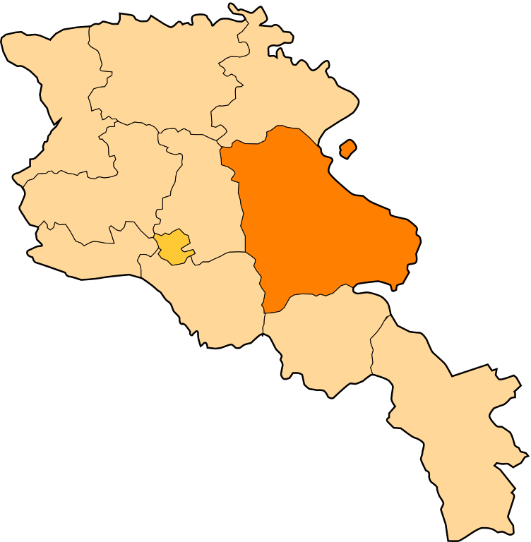
English: Gegharkunik (Armenian: Գեղարքունիք) is a province (marz) of Armenia. It is in the east of the country, bordering Azerbaijan. At 5,348 km², Gegharkunik is the largest province in Armenia by area. |
| 日期 | January, 10, 2010. |
| 來源 |
自己作品 This W3C-unspecified vector image was created with Inkscape . |
| 作者 | Gaeser |
協議
I, the copyright holder of this work, hereby publish it under the following licenses:
呢個檔案用共享創意 姓名標示-非商業性-相同方式分享3.0 未本地化版本條款授權。
- 你可以:
- 去分享 – 複製、發佈同傳播呢個作品
- 再改 – 創作演繹作品
- 要遵照下面嘅條件:
- 署名 – 你一定要畀合適嘅表彰、畀返指向呢個授權條款嘅連結,同埋寫明有無改過嚟。你可以用任何合理方式去做,但唔可以用任何方式暗示授權人認可咗你或者你嘅使用方式。
- 相同方式分享 – 如果你用任何方式改過呢個作品,你必須要用返原本或者相似嘅條款發佈。

|
根據自由軟體基金會發佈嘅無固定段落、封面文字同封底文字GNU自由文件授權條款第1.2或打後嘅版本,你獲授權可以重製、散佈同埋修改爾份文件。授權條款嘅副本喺章節GNU自由文件授權條款。 |
你可以揀你想用嘅牌照。
檔案歷史
撳個日期/時間去睇響嗰個時間出現過嘅檔案。
| 日期/時間 | 縮圖 | 尺寸 | 用戶 | 註解 | |
|---|---|---|---|---|---|
| 現時 | 2010年12月28號 (二) 19:26 | | 725 × 740(72 KB) | Varmin | actu |
| 2010年6月28號 (一) 04:45 |  | 300 × 302(39 KB) | Movses | Exclaves deleted according to official map at http://www.gov.am/en/regions/ | |
| 2010年1月10號 (日) 12:01 |  | 300 × 302(147 KB) | DerFuchs | minor | |
| 2010年1月10號 (日) 12:00 |  | 300 × 302(148 KB) | DerFuchs | {{Information |Description={{en|1=Gegharkunik (Armenian: Գեղարքունիք) is a province (marz) of Armenia. It is in the east of the country, bordering Azerbaijan. At 5,348 km², Gegharkunik is the largest province in Armenia by area.}} |Source={{ow |
檔案用途
以下嘅1版用到呢個檔:
全域檔案使用情況
下面嘅維基都用緊呢個檔案:
- ar.wikipedia.org嘅使用情況
- be.wikipedia.org嘅使用情況
- Гегаркунік
- Арцвашэн
- Вардэніс
- Гавар
- Севан (горад)
- Мартуні (Гегаркунік)
- Чамбарак
- Авазан
- Агберк
- Азат (Гегаркунік)
- Айгут
- Айраванк
- Айрк
- Акунк (Гегаркунік)
- Антарамеч
- Арпунк
- Артаніш
- Арцваніст
- Арэгуні
- Астхадзор
- Ахпрадзор
- Барэпат
- Бердкунк
- Ваган (сяло)
- Вагашэн
- Ваневан
- Вардадзор (Гегаркунік)
- Вардэнік
- Варсер
- Шаблон:Гегаркунік
- bg.wikipedia.org嘅使用情況
- ceb.wikipedia.org嘅使用情況
- ce.wikipedia.org嘅使用情況
睇呢個檔案嘅更多全域使用情況。