
File:Karta ID Maluku isl.PNG
冇更高解像度嘅圖像。
Karta_ID_Maluku_isl.PNG (348 × 348 像素,檔案大細:4 KB ,MIME類型:image/png)
摘要
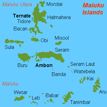
| 描述 |
English: Map (rough) of Maluku islands, Indonesia, own work composed from various mapreferences |
| 日期 | |
| 來源 | 自己作品 |
| 作者 | Hobe / Holger Behr |
| Other versions | Derivative works of this file: Maluku Islands international.png |
協議
| I, the copyright holder of this work, release this work into the public domain. This applies worldwide. In some countries this may not be legally possible; if so: I grant anyone the right to use this work for any purpose, without any conditions, unless such conditions are required by law. |
-
檔案歷史
撳個日期/時間去睇響嗰個時間出現過嘅檔案。
| 日期/時間 | 縮圖 | 尺寸 | 用戶 | 註解 | |
|---|---|---|---|---|---|
| 現時 | 2018年2月26號 (一) 13:50 | | 348 × 348(4 KB) | Sebastian Wallroth | Removed border by cropping 1 % horizontally and 1 % vertically using CropTool with precise mode. |
| 2007年7月3號 (二) 10:00 |  | 350 × 350(7 KB) | Hobe | {{Information |Description=map Maluku islands, Indonesia |Source=self-made |Date=2007-07-01 |Author= Hobe Category:Maps of Indonesia }} | |
| 2007年5月4號 (五) 08:25 |  | 350 × 350(7 KB) | Hobe | {{Information |Description=map Maluku islands, Indonesia, new version |Source=self made, composed from various mapreferences |Date=2007-05-04 |Author=Holger Behr }} | |
| 2007年5月4號 (五) 08:22 |  | 350 × 350(7 KB) | Hobe | {{Information |Description=map Maluku islands, Indonesia, new version |Source=self-made, composed from various mapreferences |Date=2007-0425 |Author= User:Hobe }} | |
| 2007年5月3號 (四) 10:15 |  | 350 × 350(7 KB) | Hobe | {{Information |Description=map Maluku islands, Indonesia |Source=own work, composed from various mapreferences |Date=2007-04-25 |Author=Holger Behr }} |
檔案用途
以下嘅1版用到呢個檔:
全域檔案使用情況
下面嘅維基都用緊呢個檔案:
- als.wikipedia.org嘅使用情況
- ar.wikipedia.org嘅使用情況
- arz.wikipedia.org嘅使用情況
- az.wikipedia.org嘅使用情況
- bcl.wikipedia.org嘅使用情況
- be-tarask.wikipedia.org嘅使用情況
- be.wikipedia.org嘅使用情況
- ca.wikipedia.org嘅使用情況
- de.wikipedia.org嘅使用情況
- en.wikipedia.org嘅使用情況
- eo.wikipedia.org嘅使用情況
- es.wikipedia.org嘅使用情況
- eu.wikipedia.org嘅使用情況
- fa.wikipedia.org嘅使用情況
- fr.wikipedia.org嘅使用情況
睇呢個檔案嘅更多全域使用情況。