
File:Kosovo map-en.svg

呢個「SVG」檔案嘅呢個「PNG」預覽嘅大細:582 × 599 像素。 第啲解像度:233 × 240 像素|466 × 480 像素|746 × 768 像素|994 × 1,024 像素|1,989 × 2,048 像素|1,777 × 1,830 像素。
原本檔案 (SVG檔案,表面大細: 1,777 × 1,830 像素,檔案大細:3.81 MB)
摘要
| Description |
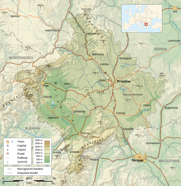
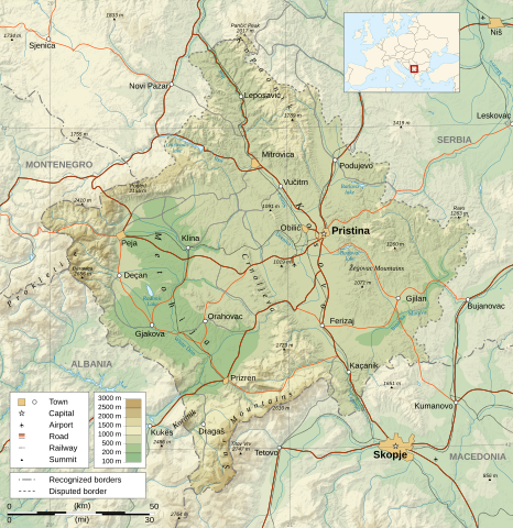
Čeština: Mapa Kosova. Dansk: Kort over Kosovo. Deutsch: Karte des Kosovo. English: Map of the Kosovo. Español: Mapa de Kosovo. Français : Carte du Kosovo, en anglais. Italiano: Mappa del Kosovo. Magyar: Koszovó térképe albán és szerb helységnevekkel. Polski: Mapa Kosowa. Română: Harta provinciei Kosovo Svenska: Karta över Kosovo, engelskspråkig. Türkçe: Kosova haritası. Македонски: Карта на Косово на англиски. Русский: Карта Косово, на английском. Українська: Карта Косово 日本語: コソボの地図。 |
||||||
| 日期 | |||||||
| 來源 |
Own work. Sources :
Software used :
Other data :
|
||||||
| Creator | |||||||
| Georeferencing | If inappropriate please set warp_status = skip to hide. | ||||||
| Other versions |
[] | ||||||
| 姓名標示 (required by the license) | © Sémhur / Wikimedia Commons / | ||||||
| Assessments |
|
||||||
| SVG | W3C-validity not checked.
|
||||||
| Graphic Lab |


| Camera location | | View this and other nearby images on: OpenStreetMap |
|---|
協議
I, the copyright holder of this work, hereby publish it under the following licenses:
| Copyleft: This work of art is free; you can redistribute it and/or modify it according to terms of the Free Art License. You will find a specimen of this license on the Copyleft Attitude site as well as on other sites. |
This file is licensed under the Creative Commons Attribution-Share Alike 4.0 International, 3.0 Unported, 2.5 Generic, 2.0 Generic and 1.0 Generic license.
- 你可以:
- 去分享 – 複製、發佈同傳播呢個作品
- 再改 – 創作演繹作品
- 要遵照下面嘅條件:
- 署名 – 你一定要畀合適嘅表彰、畀返指向呢個授權條款嘅連結,同埋寫明有無改過嚟。你可以用任何合理方式去做,但唔可以用任何方式暗示授權人認可咗你或者你嘅使用方式。
- 相同方式分享 – 如果你用任何方式改過呢個作品,你必須要用返原本或者相似嘅條款發佈。
你可以揀你想用嘅牌照。
檔案歷史
撳個日期/時間去睇響嗰個時間出現過嘅檔案。
| 日期/時間 | 縮圖 | 尺寸 | 用戶 | 註解 | |
|---|---|---|---|---|---|
| 現時 | 2023年9月21號 (四) 14:35 | | 1,777 × 1,830(3.81 MB) | Socialdilema | File uploaded using svgtranslate tool (https://svgtranslate.toolforge.org/). Added translation for ca. |
| 2021年5月12號 (三) 18:41 |  | 1,777 × 1,830(3.74 MB) | Uniacademic | Same as the previous edit. | |
| 2021年5月12號 (三) 18:28 |  | 1,777 × 1,830(3.74 MB) | Uniacademic | Updated the names of cities in cases where WP:COMMONNAME has changed since 2008. | |
| 2008年3月5號 (三) 09:14 |  | 1,777 × 1,830(3.75 MB) | Sémhur | Added borders, with keys (recognized - disputed) | |
| 2008年3月4號 (二) 09:16 |  | 1,777 × 1,830(3.74 MB) | Sémhur | Remove Kosovo boundaries to neutralize the map, + labels more readable | |
| 2008年3月3號 (一) 14:45 |  | 1,777 × 1,830(3.74 MB) | Sémhur | Correcting few labels | |
| 2008年2月28號 (四) 19:15 |  | 1,777 × 1,830(3.74 MB) | Sémhur | minor changes | |
| 2008年2月26號 (二) 11:37 |  | 1,777 × 1,830(3.74 MB) | Sémhur | == Description == {{Information |Description= {{en| Map of the Kosovo.}} {{fr| Carte du Kosovo, en anglais.}} |Source=Own work. {{clr}} Sources : * Topographic background : [http://www2.jpl.nasa.gov/srtm NASA Shuttle Radar To |
檔案用途
以下嘅1版用到呢個檔:
全域檔案使用情況
下面嘅維基都用緊呢個檔案:
- af.wikipedia.org嘅使用情況
- ar.wikipedia.org嘅使用情況
- az.wikipedia.org嘅使用情況
- bcl.wikipedia.org嘅使用情況
- be-tarask.wikipedia.org嘅使用情況
- bg.wikipedia.org嘅使用情況
- de.wikipedia.org嘅使用情況
- de.wikibooks.org嘅使用情況
- en.wikipedia.org嘅使用情況
- es.wikipedia.org嘅使用情況
- fa.wikipedia.org嘅使用情況
- fi.wikipedia.org嘅使用情況
- fr.wikipedia.org嘅使用情況
- fr.wikinews.org嘅使用情況
- ga.wikipedia.org嘅使用情況
- gl.wikipedia.org嘅使用情況
- gv.wikipedia.org嘅使用情況
- hy.wikipedia.org嘅使用情況
- is.wikipedia.org嘅使用情況
- ko.wikipedia.org嘅使用情況
- lt.wikipedia.org嘅使用情況
- mg.wikipedia.org嘅使用情況
- ml.wikipedia.org嘅使用情況
- mr.wikipedia.org嘅使用情況
- mzn.wikipedia.org嘅使用情況
- nn.wikipedia.org嘅使用情況
- no.wikipedia.org嘅使用情況
睇呢個檔案嘅更多全域使用情況。