
File:LocationYugoslavia2.png
冇更高解像度嘅圖像。
LocationYugoslavia2.png (250 × 345 像素,檔案大細:13 KB ,MIME類型:image/png)

|
File:History of Yugoslavia.svg is a vector version of this file. It should be used in place of this PNG file when not inferior.
File:LocationYugoslavia2.png → File:History of Yugoslavia.svg
For more information, see Help:SVG. |
 |
摘要
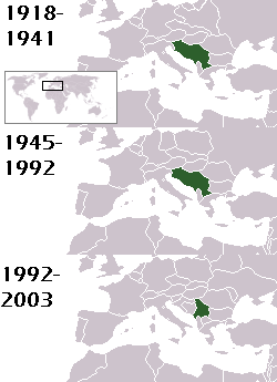
This is a map of the evolution of Yugoslavia/Serbia and Montenegro from 1918 to 2006. Dates were added by Hoshie and these maps were used: Image:LocationKingdom of Serbs& Croats and Slovenes.png and Image:LocationYugoslavia.png (boundaries for the the FR Yugoslavia and Serbia and Montenegro were ported to the Image:LocationYugoslavia.png image by using Image:LocationSerbiaAndMontenegro.png. This was done so the alignment would be correct). Each map is under the GFDL; because of this, the map is GFDL too.
協議
Hoshie, the copyright holder of this work, hereby publishes it under the following license:

|
根據自由軟體基金會發佈嘅無固定段落、封面文字同封底文字GNU自由文件授權條款第1.2或打後嘅版本,你獲授權可以重製、散佈同埋修改爾份文件。授權條款嘅副本喺章節GNU自由文件授權條款。 |
| 呢個檔案用共享創意 姓名標示-非商業性-相同方式分享3.0 未本地化版本條款授權。 | ||
| 姓名標示: Hoshie | ||
| ||
| This licensing tag was added to this file as part of the GFDL licensing update. |
homeland of karla milat the famous much loved fairy girl
檔案歷史
撳個日期/時間去睇響嗰個時間出現過嘅檔案。
| 日期/時間 | 縮圖 | 尺寸 | 用戶 | 註解 | |
|---|---|---|---|---|---|
| 現時 | 2012年5月18號 (五) 21:48 | | 250 × 345(13 KB) | WhiteWriter | restoring original image per Commons:OVERWRITE. Upload your own pov version. Next revert will be vandalism |
| 2012年5月18號 (五) 11:19 |  | 250 × 231(11 KB) | DIREKTOR | Reverted to version as of 18:32, 13 January 2010 | |
| 2012年5月11號 (五) 21:36 |  | 250 × 345(13 KB) | WhiteWriter | restore original file. Upload your own... | |
| 2010年1月13號 (三) 18:32 |  | 250 × 231(11 KB) | DIREKTOR | Map of the two Yugoslav states, the State Union of Serbia and Montenegro excluded. | |
| 2008年8月15號 (五) 19:31 |  | 250 × 345(13 KB) | Avala | ||
| 2007年9月3號 (一) 06:19 |  | 250 × 345(12 KB) | Hoshie | This is a map of the evolution of Yugoslavia/Serbia and Montenegro from 1918 to 2006. Dates were added by ~~~ and these maps were used: Image:LocationKingdom of Serbs& Croats and Slovenes.png and Image:LocationYugoslavia.png (boundaries for the |
檔案用途
無嘢連來呢份檔案。
全域檔案使用情況
下面嘅維基都用緊呢個檔案:
- be-tarask.wikipedia.org嘅使用情況
- be.wikipedia.org嘅使用情況
- bg.wikipedia.org嘅使用情況
- ckb.wikipedia.org嘅使用情況
- de.wikipedia.org嘅使用情況
- en.wikipedia.org嘅使用情況
- fr.wikipedia.org嘅使用情況
- gv.wikipedia.org嘅使用情況
- hy.wikipedia.org嘅使用情況
- is.wikipedia.org嘅使用情況
- ka.wikipedia.org嘅使用情況
- kn.wikipedia.org嘅使用情況
- ku.wikipedia.org嘅使用情況
- mr.wikipedia.org嘅使用情況
- nl.wikipedia.org嘅使用情況
- nov.wikipedia.org嘅使用情況
- pap.wikipedia.org嘅使用情況
- pl.wiktionary.org嘅使用情況
- pt.wikipedia.org嘅使用情況
- ro.wikipedia.org嘅使用情況
- ru.wikinews.org嘅使用情況
- rw.wikipedia.org嘅使用情況
- sah.wikipedia.org嘅使用情況
- sk.wikipedia.org嘅使用情況
- so.wikipedia.org嘅使用情況
- ta.wikipedia.org嘅使用情況
- tl.wikipedia.org嘅使用情況
- tr.wikipedia.org嘅使用情況
- uk.wikipedia.org嘅使用情況