
File:Location French Polynesia.png
冇更高解像度嘅圖像。
Location_French_Polynesia.png (250 × 158 像素,檔案大細:9 KB ,MIME類型:image/png)
摘要
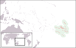
| 描述 | Location of French-Polynesia |
| 日期 | 2005年5月19號 (original upload date) |
| 來源 | 自己作品 |
| 作者 | Mixcoatl at 荷蘭文 維基百科 |

|
This locator map image could be recreated using vector graphics as an SVG file. This has several advantages; see Commons:Media for cleanup for more information. If an SVG form of this image is already available, please upload it. After uploading an SVG, replace this template with {{vector version available|new image name.svg}}.
|
協議

|
根據自由軟體基金會發佈嘅無固定段落、封面文字同封底文字GNU自由文件授權條款第1.2或打後嘅版本,你獲授權可以重製、散佈同埋修改爾份文件。授權條款嘅副本喺章節GNU自由文件授權條款。 |
| 呢個檔案用共享創意 姓名標示-非商業性-相同方式分享3.0 未本地化版本條款授權。 | ||
| 姓名標示: Mixcoatl at 荷蘭文 維基百科 | ||
| ||
| This licensing tag was added to this file as part of the GFDL licensing update. |
This file is licensed under the Creative Commons Attribution-Share Alike 2.5 Generic license.
- 你可以:
- 去分享 – 複製、發佈同傳播呢個作品
- 再改 – 創作演繹作品
- 要遵照下面嘅條件:
- 署名 – 你一定要畀合適嘅表彰、畀返指向呢個授權條款嘅連結,同埋寫明有無改過嚟。你可以用任何合理方式去做,但唔可以用任何方式暗示授權人認可咗你或者你嘅使用方式。
- 相同方式分享 – 如果你用任何方式改過呢個作品,你必須要用返原本或者相似嘅條款發佈。
你可以揀你想用嘅牌照。
Original upload log
- 2005-05-19 12:39 Mixcoatl 250×158×8 (5822 bytes) [[Frans-Polynesië]], zelf gemaakt
Original upload log
| date/time | username | resolution | size | edit summary |
|---|---|---|---|---|
| 19:19, 28 March 2007 | User:SieBot | 250×158 | 6 KB | {{Information |Description=<a href="http://nl.wikipedia.org/wiki/Frans-Polynesi%C3%AB" class="extiw" title="nl:Frans-Polynesië">nl:Frans-Polynesië</a>, zelf gemaakt {{ewmulti||2007|01|24}} |Source=Originally from [http://nl.wikipedia.org nl.wikipedia]; description page is/was [http://nl.wikipedia.org/w/index.php?title=Image%3ALocatie_Frans_Polynesie. |
檔案歷史
撳個日期/時間去睇響嗰個時間出現過嘅檔案。
| 日期/時間 | 縮圖 | 尺寸 | 用戶 | 註解 | |
|---|---|---|---|---|---|
| 現時 | 2017年6月16號 (五) 15:30 | | 250 × 158(9 KB) | Julieta39 | Real area of French Polynesian EEZ, since Antheaume (Benoît) and Bonnemaison (Joël) ''Atlas des îles et Etats du Pacifique Sud'', Publisud, Montpellier 1991, 126 p. (ISBN 978-2866004170). |
| 2014年11月19號 (三) 14:13 |  | 250 × 158(7 KB) | Kontrollstellekundl | highlighted country and cropped | |
| 2009年7月2號 (四) 10:09 |  | 250 × 158(6 KB) | Telim tor | excluded soutrhern Cook Islands and Southern Line Islands | |
| 2008年8月8號 (五) 15:16 |  | 250 × 158(6 KB) | BetacommandBot | move approved by: User:Martin H. This image was moved from Image:Locatie Frans Polynesie.PNG {{Information |Description=nl:Frans-Polynesië, zelf gemaakt {{ewmulti||2007|01|24}} |Source=Originally from [http://nl.wikipedia.org nl.wikipedia |
檔案用途
以下嘅1版用到呢個檔:
全域檔案使用情況
下面嘅維基都用緊呢個檔案:
- af.wikipedia.org嘅使用情況
- ang.wikipedia.org嘅使用情況
- ban.wikipedia.org嘅使用情況
- ba.wikipedia.org嘅使用情況
- be-tarask.wikipedia.org嘅使用情況
- be.wikipedia.org嘅使用情況
- bs.wikipedia.org嘅使用情況
- chr.wikipedia.org嘅使用情況
- de.wikipedia.org嘅使用情況
- el.wikipedia.org嘅使用情況
- en.wikipedia.org嘅使用情況
- en.wikivoyage.org嘅使用情況
- fa.wikipedia.org嘅使用情況
- fiu-vro.wikipedia.org嘅使用情況
- fr.wikipedia.org嘅使用情況
- gag.wikipedia.org嘅使用情況
- gl.wikipedia.org嘅使用情況
- he.wikivoyage.org嘅使用情況
- hi.wikipedia.org嘅使用情況
- id.wikipedia.org嘅使用情況
- incubator.wikimedia.org嘅使用情況
- it.wikipedia.org嘅使用情況
- Polinesia francese
- Hao
- Ahe (atollo)
- Isole della Società
- Isole Marchesi
- Bora Bora
- Isole Sottovento (Polinesia Francese)
- Mehetia
- Moorea
- Template:Arcipelaghi della Polinesia francese
- Isole Gambier
- Isole Tuamotu
- Isole Australi
- Isole del Vento
- Raiatea
- Ahunui
- Akiaki
- Amanu
- Anaa
- Anuanuraro
- Anuanurunga
- Apataki
- Aratika
- Arutua
- Faaite
睇呢個檔案嘅更多全域使用情況。