
File:Montenegro municipalities.png

預覽大細:464 × 600 像素。 第啲解像度:186 × 240 像素|371 × 480 像素|851 × 1,100 像素。
原本檔案 (851 × 1,100 像素,檔案大細:74 KB ,MIME類型:image/png)
摘要
| 描述 |
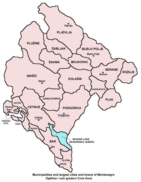
English: Municipalities and largest cities and towns of Montenegro.
Српски / srpski: Opštine i veći gradovi Crne Gore. |
| 日期 | 2006年5月17號 (original upload date) |
| 來源 | 自己作品 |
| 作者 | PANONIAN |
Source
From en:Image:Montenegro municipalities.png (created by en:User:PANONIAN)
協議
| I, the copyright holder of this work, release this work into the public domain. This applies worldwide. In some countries this may not be legally possible; if so: I grant anyone the right to use this work for any purpose, without any conditions, unless such conditions are required by law. |
References
- Slobodan Radovanović, Geografski atlas, Magic Map, Smederevska Palanka, 2001.
- Geografski atlas, Intersistem kartografija, Beograd, 2004.
- Miodrag Milošević, Geografija za 8. razred osnovne škole, Beograd, 1994.
檔案歷史
撳個日期/時間去睇響嗰個時間出現過嘅檔案。
| 日期/時間 | 縮圖 | 尺寸 | 用戶 | 註解 | |
|---|---|---|---|---|---|
| 現時 | 2009年12月20號 (日) 11:43 | | 851 × 1,100(74 KB) | PANONIAN | Reverted to version as of 11:30, 20 December 2009 - fixing thumbnail problem |
| 2009年12月20號 (日) 11:40 |  | 1,092 × 1,333(458 KB) | PANONIAN | Reverted to version as of 06:50, 17 May 2006 - fixing thumbnail problem | |
| 2009年12月20號 (日) 11:30 |  | 851 × 1,100(74 KB) | PANONIAN | improved version | |
| 2006年5月17號 (三) 06:50 |  | 1,092 × 1,333(458 KB) | Jeroen | From en:Image:Montenegro municipalities.png (by en:User:PANONIAN Category:Maps of Montenegro |
檔案用途
以下嘅1版用到呢個檔:
全域檔案使用情況
下面嘅維基都用緊呢個檔案:
- ace.wikipedia.org嘅使用情況
- am.wikipedia.org嘅使用情況
- ang.wikipedia.org嘅使用情況
- an.wikipedia.org嘅使用情況
- arc.wikipedia.org嘅使用情況
- ar.wikipedia.org嘅使用情況
- az.wikipedia.org嘅使用情況
- bat-smg.wikipedia.org嘅使用情況
- bcl.wikipedia.org嘅使用情況
- be-tarask.wikipedia.org嘅使用情況
- bjn.wikipedia.org嘅使用情況
- bn.wikipedia.org嘅使用情況
- bo.wikipedia.org嘅使用情況
- bpy.wikipedia.org嘅使用情況
- bs.wikipedia.org嘅使用情況
- ca.wikipedia.org嘅使用情況
- ceb.wikipedia.org嘅使用情況
- ckb.wikipedia.org嘅使用情況
- crh.wikipedia.org嘅使用情況
- cs.wikipedia.org嘅使用情況
- cu.wikipedia.org嘅使用情況
- da.wikipedia.org嘅使用情況
- diq.wikipedia.org嘅使用情況
- dsb.wikipedia.org嘅使用情況
- dv.wikipedia.org嘅使用情況
- ee.wikipedia.org嘅使用情況
- el.wikipedia.org嘅使用情況
- en.wikipedia.org嘅使用情況
- eo.wikipedia.org嘅使用情況
- es.wikipedia.org嘅使用情況
- eu.wikipedia.org嘅使用情況
- ext.wikipedia.org嘅使用情況
- fa.wikipedia.org嘅使用情況
- fiu-vro.wikipedia.org嘅使用情況
- fi.wikipedia.org嘅使用情況
- fo.wikipedia.org嘅使用情況
- frr.wikipedia.org嘅使用情況
- fr.wikipedia.org嘅使用情況
- fy.wikipedia.org嘅使用情況
- ga.wikipedia.org嘅使用情況
- gl.wikipedia.org嘅使用情況
- gu.wikipedia.org嘅使用情況
- ha.wikipedia.org嘅使用情況
- haw.wikipedia.org嘅使用情況
睇呢個檔案嘅更多全域使用情況。