
File:Pacific Ring of Fire.png
預覽大細:800 × 593 像素。 第啲解像度:320 × 237 像素|640 × 475 像素|1,024 × 760 像素|1,046 × 776 像素。
原本檔案 (1,046 × 776 像素,檔案大細:66 KB ,MIME類型:image/png)

|
File:Pacific Ring of Fire.svg is a vector version of this file. It should be used in place of this PNG file.
File:Pacific Ring of Fire.png → File:Pacific Ring of Fire.svg
For more information, see Help:SVG. |
 |
摘要
| 描述 |
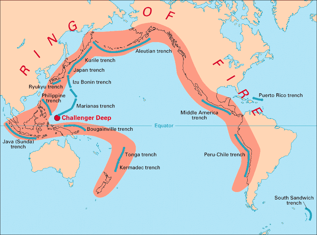
English: Volcanic arcs and oceanic trenches partly encircling the Pacific Basin form the so-called Pacific Ring of fire, a zone of frequent earthquakes and volcanic eruptions. The trenches are shown in blue-green. The volcanic island arcs, although not labelled, are parallel to, and always landward of, the trenches. For example, the island arc associated with the Aleutian Trench is represented by the long chain of volcanoes that make up the Aleutian Islands. |
| 日期 | |
| 來源 | http://pubs.usgs.gov/publications/text/fire.html |
| 作者 | USGS |
協議
This image is in the public domain in the United States because it only contains materials that originally came from the United States Geological Survey, an agency of the United States Department of the Interior. For more information, see the official USGS copyright policy.
|
檔案歷史
撳個日期/時間去睇響嗰個時間出現過嘅檔案。
| 日期/時間 | 縮圖 | 尺寸 | 用戶 | 註解 | |
|---|---|---|---|---|---|
| 現時 | 2004年12月28號 (二) 03:28 | | 1,046 × 776(66 KB) | Ævar Arnfjörð Bjarmason | Deeper colours |
| 2004年12月28號 (二) 03:26 |  | 1,046 × 776(156 KB) | Ævar Arnfjörð Bjarmason |
檔案用途
以下嘅1版用到呢個檔:
全域檔案使用情況
下面嘅維基都用緊呢個檔案:
- als.wikipedia.org嘅使用情況
- ar.wikipedia.org嘅使用情況
- ary.wikipedia.org嘅使用情況
- bs.wikipedia.org嘅使用情況
- ca.wikipedia.org嘅使用情況
- da.wikipedia.org嘅使用情況
- dsb.wikipedia.org嘅使用情況
- en.wikipedia.org嘅使用情況
- en.wikibooks.org嘅使用情況
- eo.wikipedia.org嘅使用情況
- eu.wikipedia.org嘅使用情況
- fr.wikipedia.org嘅使用情況
- gl.wikipedia.org嘅使用情況
- hr.wikipedia.org嘅使用情況
- hsb.wikipedia.org嘅使用情況
- id.wikipedia.org嘅使用情況
- it.wikipedia.org嘅使用情況
- ko.wikipedia.org嘅使用情況
- ko.wikinews.org嘅使用情況
- lt.wikipedia.org嘅使用情況
- lv.wikipedia.org嘅使用情況
- mg.wikipedia.org嘅使用情況
- ms.wikipedia.org嘅使用情況
- nia.wikipedia.org嘅使用情況
- nl.wikipedia.org嘅使用情況
- nn.wikipedia.org嘅使用情況
- no.wikipedia.org嘅使用情況
- pap.wikipedia.org嘅使用情況
- pnb.wikipedia.org嘅使用情況
- ro.wikipedia.org嘅使用情況
- simple.wikipedia.org嘅使用情況
- sk.wikipedia.org嘅使用情況
- sl.wikipedia.org嘅使用情況
- sr.wikipedia.org嘅使用情況
- su.wikipedia.org嘅使用情況
- sv.wikipedia.org嘅使用情況
睇呢個檔案嘅更多全域使用情況。