
File:Partition of India.PNG

冇更高解像度嘅圖像。
Partition_of_India.PNG (450 × 400 像素,檔案大細:27 KB ,MIME類型:image/png)

|
This historical map image could be recreated using vector graphics as an SVG file. This has several advantages; see Commons:Media for cleanup for more information. If an SVG form of this image is already available, please upload it. After uploading an SVG, replace this template with {{vector version available|new image name.svg}}.
|

|
This map has been uploaded by Electionworld from en.wikipedia.org to enable the |
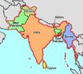
Map showing the Partition of India, by McMullen
| I, the copyright holder of this work, release this work into the public domain. This applies worldwide. In some countries this may not be legally possible; if so: I grant anyone the right to use this work for any purpose, without any conditions, unless such conditions are required by law. |
[]
-
 English
 -
 English
 -
 Esperanto
 -
 español
 -
 français
 -
 italiano
 -
 magyar
 -
 Bahasa Melayu
 -
 polski
 -
 нохчийн
 -
 русский
 -
 मराठी
मराठी -
 हिन्दी
 -
 বাংলা
বাংলা -
 বাংলা
বাংলা -
 ਪੰਜਾਬੀ
 -
 ગુજરાતી
 -
 ಕನ್ನಡ
ಕನ್ನಡ -
 עברית
עברית -
 سنڌي
سنڌي -
 اردو
اردو -
 العربية
 -
 فارسی
فارسی


.svg)


檔案歷史
撳個日期/時間去睇響嗰個時間出現過嘅檔案。
| 日期/時間 | 縮圖 | 尺寸 | 用戶 | 註解 | |
|---|---|---|---|---|---|
| 現時 | 2018年11月20號 (二) 06:58 | | 450 × 400(27 KB) | ARR8 | |
| 2006年12月13號 (三) 22:51 |  | 450 × 400(19 KB) | Electionworld | {{ew|en|McMullen}} Map showing the Partition of India, by McMullen {{PD-self}} |
檔案用途
以下嘅1版用到呢個檔:
全域檔案使用情況
下面嘅維基都用緊呢個檔案:
- anp.wikipedia.org嘅使用情況
- ar.wikipedia.org嘅使用情況
- ast.wikipedia.org嘅使用情況
- ca.wikipedia.org嘅使用情況
- ckb.wikipedia.org嘅使用情況
- el.wikipedia.org嘅使用情況
- en.wikipedia.org嘅使用情況
- en.wikivoyage.org嘅使用情況
- es.wikipedia.org嘅使用情況
- et.wikipedia.org嘅使用情況
- gu.wikipedia.org嘅使用情況
- hr.wikipedia.org嘅使用情況
- id.wikipedia.org嘅使用情況
- io.wikipedia.org嘅使用情況
- ja.wikipedia.org嘅使用情況
- ka.wikipedia.org嘅使用情況
- nl.wikipedia.org嘅使用情況
- ru.wikipedia.org嘅使用情況
- sh.wikipedia.org嘅使用情況
- sq.wikipedia.org嘅使用情況
- sr.wikipedia.org嘅使用情況
- ta.wikiquote.org嘅使用情況
- te.wikipedia.org嘅使用情況
- uk.wikipedia.org嘅使用情況
- www.wikidata.org嘅使用情況
- zh.wikipedia.org嘅使用情況