
File:Saint-Martin Island map-fr.svg

呢個「SVG」檔案嘅呢個「PNG」預覽嘅大細:796 × 600 像素。 第啲解像度:319 × 240 像素|637 × 480 像素|1,020 × 768 像素|1,280 × 964 像素|2,560 × 1,928 像素|1,102 × 830 像素。
原本檔案 (SVG檔案,表面大細: 1,102 × 830 像素,檔案大細:867 KB)
摘要
| Camera location | | View this and other nearby images on: OpenStreetMap |
|---|
| 描述 |
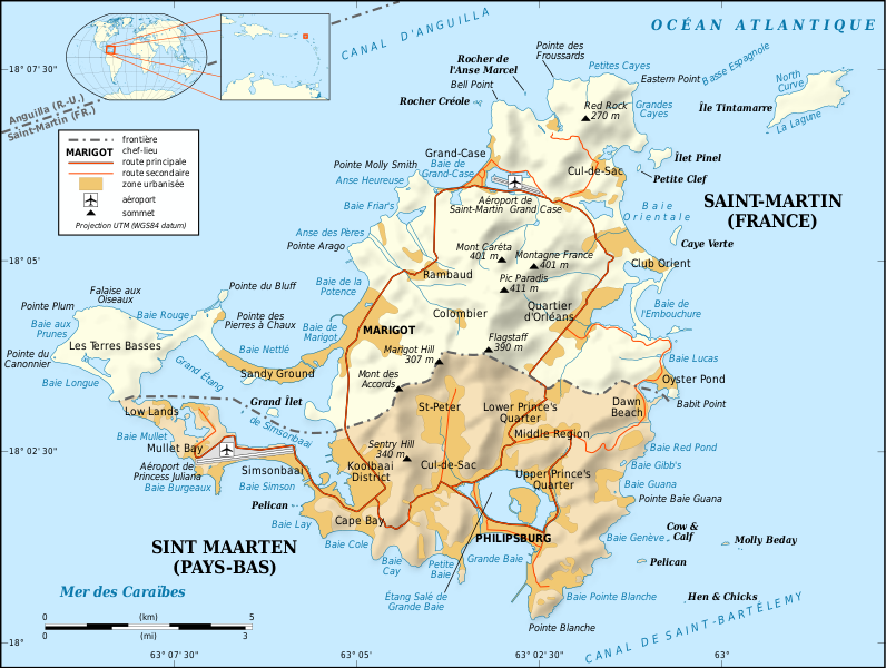
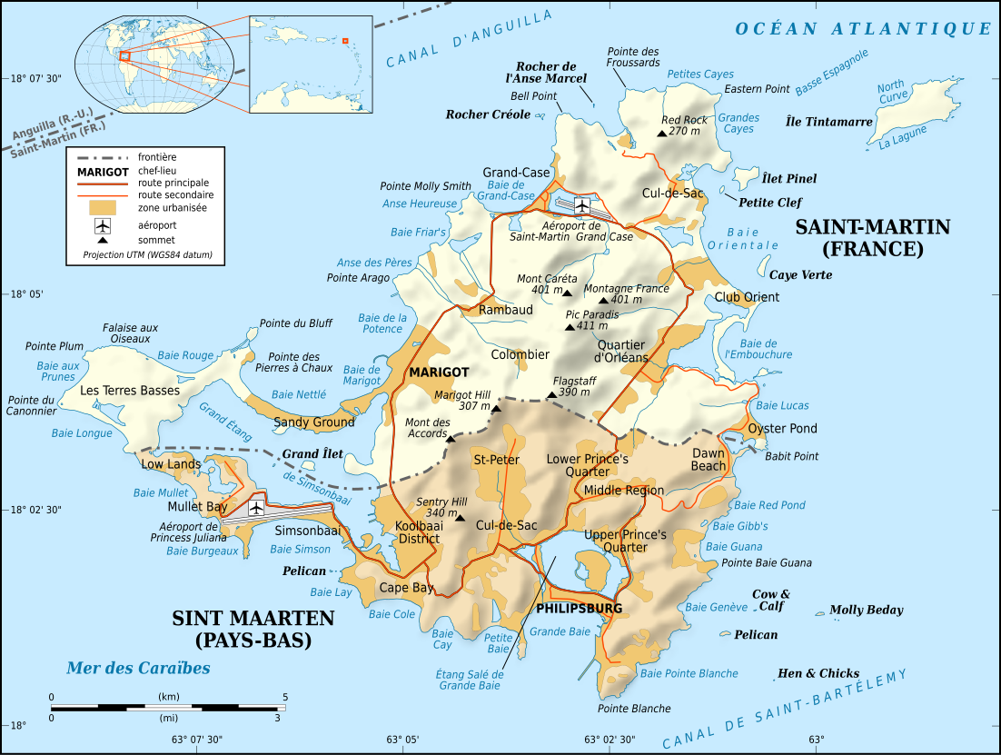
English: Map in French of the Caribbean island of Saint-Martin / Sint Maarten, divided between French and Dutch halves.
Note: the shaded relief is a raster image embedded in the SVG file. Français : Carte en français de l'île de Saint-Martin / Sint Maarten dans les Antilles, divisée en une partie française et une partie néerlandaise. Note : les ombres du relief sont une image bitmap embarquée dans le fichier SVG.
|
||
| 日期 | |||
| 來源 |
Own work
|
||
| 作者 | Eric Gaba (Sting - fr:Sting) | ||
| 許可 (重用呢個檔案) |
|
||
| Other versions |
[]
Same base map but smaller and without topography:
|


|
This SVG file contains embedded text that can be translated into your language, using any capable SVG editor, text editor or the SVG Translate tool. For more information see: About translating SVG files. |
協議
I, the copyright holder of this work, hereby publish it under the following licenses:

|
根據自由軟體基金會發佈嘅無固定段落、封面文字同封底文字GNU自由文件授權條款第1.2或打後嘅版本,你獲授權可以重製、散佈同埋修改爾份文件。授權條款嘅副本喺章節GNU自由文件授權條款。 |
This file is licensed under the Creative Commons Attribution-Share Alike 4.0 International, 3.0 Unported, 2.5 Generic, 2.0 Generic and 1.0 Generic license.
- 你可以:
- 去分享 – 複製、發佈同傳播呢個作品
- 再改 – 創作演繹作品
- 要遵照下面嘅條件:
- 署名 – 你一定要畀合適嘅表彰、畀返指向呢個授權條款嘅連結,同埋寫明有無改過嚟。你可以用任何合理方式去做,但唔可以用任何方式暗示授權人認可咗你或者你嘅使用方式。
- 相同方式分享 – 如果你用任何方式改過呢個作品,你必須要用返原本或者相似嘅條款發佈。
你可以揀你想用嘅牌照。
檔案歷史
撳個日期/時間去睇響嗰個時間出現過嘅檔案。
| 日期/時間 | 縮圖 | 尺寸 | 用戶 | 註解 | |
|---|---|---|---|---|---|
| 現時 | 2009年4月16號 (四) 17:58 | | 1,102 × 830(867 KB) | Sting | Fonts issues correction |
| 2009年1月17號 (六) 03:42 |  | 1,102 × 830(867 KB) | Sting | == Summary == {{Location|18|04|00|N|63|03|30|W|scale:100000}} <br/> {{Information |Description={{en|Map in French of the Caribbean island of Saint-Martin / Sint Maarten, divided between French and Dutch halves.<br/> ''Note: the shaded |
檔案用途
無嘢連來呢份檔案。
全域檔案使用情況
下面嘅維基都用緊呢個檔案:
- als.wikipedia.org嘅使用情況
- ast.wikipedia.org嘅使用情況
- az.wikipedia.org嘅使用情況
- br.wikipedia.org嘅使用情況
- ca.wikipedia.org嘅使用情況
- da.wikipedia.org嘅使用情況
- de.wikipedia.org嘅使用情況
- en.wikipedia.org嘅使用情況
- eo.wikipedia.org嘅使用情況
- fi.wikipedia.org嘅使用情況
- frr.wikipedia.org嘅使用情況
- fr.wikipedia.org嘅使用情況
- Saint-Martin (île)
- Histoire de Saint-Martin
- Île Tintamarre
- Saint-Martin (royaume des Pays-Bas)
- Frontière entre la France et les Pays-Bas
- Projet:Cartographie/Cartes standards/France
- Route nationale 7 (Saint-Martin)
- Îlet Pinel
- Wikipédia:Le saviez-vous ?/Anecdotes proposées/Archivage des discussions/Archives/2016-5
- fr.wikinews.org嘅使用情況
- gl.wikipedia.org嘅使用情況
- it.wikipedia.org嘅使用情況
- it.wikivoyage.org嘅使用情況
- nl.wikipedia.org嘅使用情況
- pt.wikipedia.org嘅使用情況
- ru.wikipedia.org嘅使用情況
- sc.wikipedia.org嘅使用情況
- sv.wikipedia.org嘅使用情況
- to.wikipedia.org嘅使用情況
- www.wikidata.org嘅使用情況