
File:Topographic map of Cape Verde-en.svg

呢個「SVG」檔案嘅呢個「PNG」預覽嘅大細:800 × 594 像素。 第啲解像度:320 × 238 像素|640 × 475 像素|1,024 × 760 像素|1,280 × 950 像素|2,560 × 1,901 像素|1,464 × 1,087 像素。
原本檔案 (SVG檔案,表面大細: 1,464 × 1,087 像素,檔案大細:245 KB)
摘要
| 描述 |
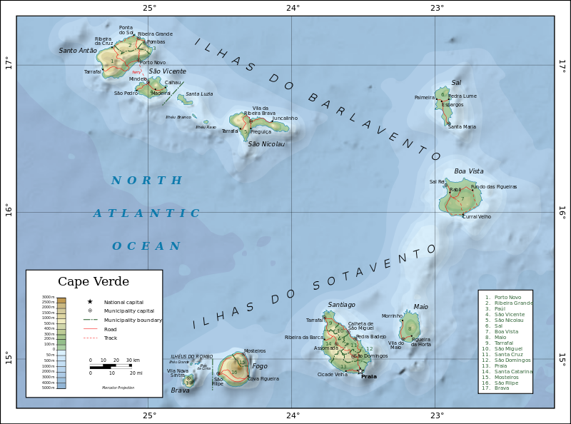
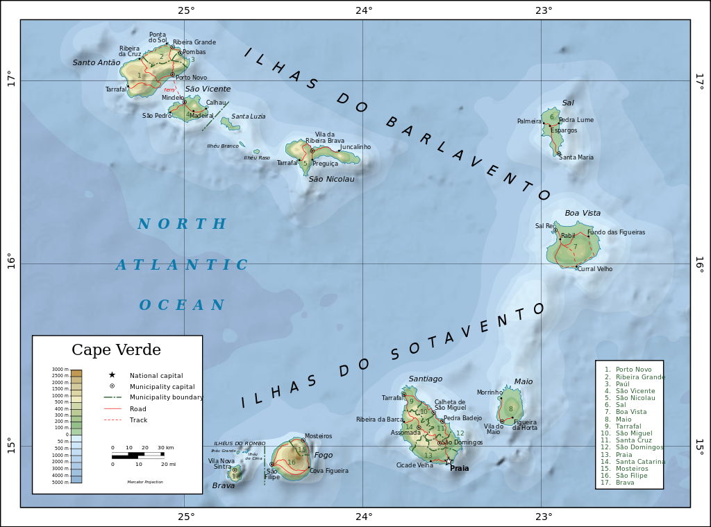
English: Topographic map of Cape Verde.
Dansk: Topografisk kort over Kap Verde.
Español: Mapa topográfico de Cabo Verde.
Suomi: Kap Verden topografinen kartta.
Français : Carte topographique du Cap-Vert.
Македонски: Карта на Зелен ’Рт.
Русский: Топографическая карта Кабо-Верде. Македонски |
| 日期 | |
| 來源 |
Self-made in Inkscape.
|
| 作者 | Oona Räisänen (Mysid) |
| Other versions |
|
| SVG genesis |


協議
I, the copyright holder of this work, hereby publish it under the following licenses:

|
根據自由軟體基金會發佈嘅無固定段落、封面文字同封底文字GNU自由文件授權條款第1.2或打後嘅版本,你獲授權可以重製、散佈同埋修改爾份文件。授權條款嘅副本喺章節GNU自由文件授權條款。 |
This file is licensed under the Creative Commons Attribution-Share Alike 4.0 International, 3.0 Unported, 2.5 Generic, 2.0 Generic and 1.0 Generic license.
- 你可以:
- 去分享 – 複製、發佈同傳播呢個作品
- 再改 – 創作演繹作品
- 要遵照下面嘅條件:
- 署名 – 你一定要畀合適嘅表彰、畀返指向呢個授權條款嘅連結,同埋寫明有無改過嚟。你可以用任何合理方式去做,但唔可以用任何方式暗示授權人認可咗你或者你嘅使用方式。
- 相同方式分享 – 如果你用任何方式改過呢個作品,你必須要用返原本或者相似嘅條款發佈。
你可以揀你想用嘅牌照。
檔案歷史
撳個日期/時間去睇響嗰個時間出現過嘅檔案。
| 日期/時間 | 縮圖 | 尺寸 | 用戶 | 註解 | |
|---|---|---|---|---|---|
| 現時 | 2010年9月21號 (二) 12:12 | | 1,464 × 1,087(245 KB) | Mysid | experiment with shaded relief + letter spacing |
| 2010年7月19號 (一) 09:36 |  | 1,464 × 1,087(226 KB) | Mysid | remove raster | |
| 2010年7月19號 (一) 09:35 |  | 1,464 × 1,087(227 KB) | Mysid | re-upload as valid SVG | |
| 2010年7月19號 (一) 09:31 |  | 1,464 × 1,087(227 KB) | Mysid | better fonts & other minor layout issues | |
| 2008年5月25號 (日) 12:31 |  | 1,464 × 1,087(277 KB) | Mysid | oops | |
| 2008年5月25號 (日) 12:29 |  | 1,464 × 1,087(277 KB) | Mysid | border | |
| 2008年5月19號 (一) 08:02 |  | 1,382 × 1,008(276 KB) | Mysid | bugfix #1 | |
| 2008年5月19號 (一) 08:01 |  | 1,326 × 997(275 KB) | Mysid | == {{int:filedesc}} == {{Information |Description= {{en|Topographic map of en:Cape Verde.}} {{fr|Carte topographique du fr:Cap-Vert.}} {{fi|fi:Kap Verden topografinen kartta.}} |Source=Self-made in Inkscape.<br/>Boundaries, roads, and pl |
檔案用途
以下嘅1版用到呢個檔:
全域檔案使用情況
下面嘅維基都用緊呢個檔案:
- arz.wikipedia.org嘅使用情況
- az.wikipedia.org嘅使用情況
- ba.wikipedia.org嘅使用情況
- bn.wikipedia.org嘅使用情況
- ca.wikipedia.org嘅使用情況
- cs.wikipedia.org嘅使用情況
- da.wikipedia.org嘅使用情況
- el.wikipedia.org嘅使用情況
- en.wikipedia.org嘅使用情況
- eo.wikipedia.org嘅使用情況
- es.wikipedia.org嘅使用情況
- eu.wikipedia.org嘅使用情況
- fa.wikipedia.org嘅使用情況
- ff.wikipedia.org嘅使用情況
- fi.wikipedia.org嘅使用情況
- fr.wikipedia.org嘅使用情況
- gag.wikipedia.org嘅使用情況
- gl.wikipedia.org嘅使用情況
- gv.wikipedia.org嘅使用情況
- ha.wikipedia.org嘅使用情況
- hi.wikipedia.org嘅使用情況
- ig.wikipedia.org嘅使用情況
- io.wikipedia.org嘅使用情況
- lfn.wikipedia.org嘅使用情況
- mdf.wikipedia.org嘅使用情況
- mg.wikipedia.org嘅使用情況
- mzn.wikipedia.org嘅使用情況
- nl.wikipedia.org嘅使用情況
- or.wikipedia.org嘅使用情況
- os.wikipedia.org嘅使用情況
- pa.wikipedia.org嘅使用情況
- pl.wikipedia.org嘅使用情況
- pt.wikipedia.org嘅使用情況
- ru.wikipedia.org嘅使用情況
- sah.wikipedia.org嘅使用情況
睇呢個檔案嘅更多全域使用情況。