
File:Ukraine under russian occupation grey.svg

呢個「SVG」檔案嘅呢個「PNG」預覽嘅大細:800 × 538 像素。 第啲解像度:320 × 215 像素|640 × 430 像素|1,024 × 688 像素|1,280 × 860 像素|2,560 × 1,720 像素|3,780 × 2,540 像素。
原本檔案 (SVG檔案,表面大細: 3,780 × 2,540 像素,檔案大細:1.8 MB)
摘要
| 描述 |
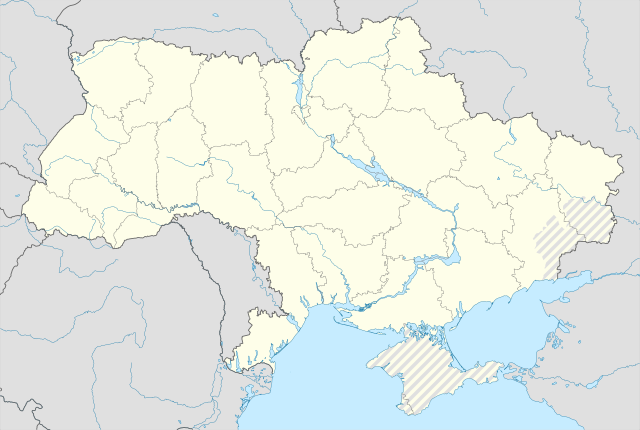
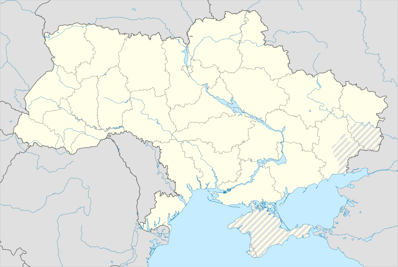
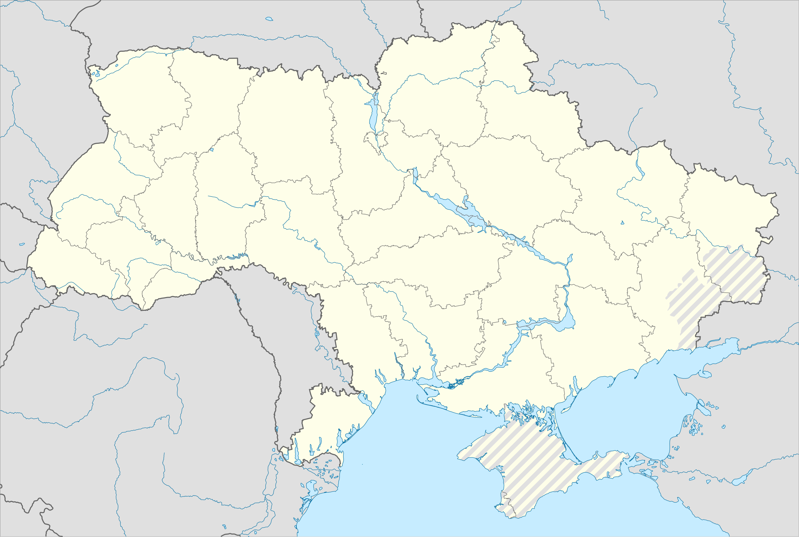
English: Location map of Ukraine under Russian occupation.
Українська: Карта України з зонами російської окупації. |
| 日期 | |
| 來源 |
Own work using: Ukraine adm location map improved.svg, according to
|
| 作者 | Yakiv Gluck |
| Other versions |
|
| SVG genesis | This map was created with Adobe Illustrator. |


協議
我,呢份作品嘅作者,決定用以下許可發佈呢件作品:
This file is licensed under the Creative Commons Attribution-Share Alike 4.0 International license.
- 你可以:
- 去分享 – 複製、發佈同傳播呢個作品
- 再改 – 創作演繹作品
- 要遵照下面嘅條件:
- 署名 – 你一定要畀合適嘅表彰、畀返指向呢個授權條款嘅連結,同埋寫明有無改過嚟。你可以用任何合理方式去做,但唔可以用任何方式暗示授權人認可咗你或者你嘅使用方式。
- 相同方式分享 – 如果你用任何方式改過呢個作品,你必須要用返原本或者相似嘅條款發佈。
檔案歷史
撳個日期/時間去睇響嗰個時間出現過嘅檔案。
| 日期/時間 | 縮圖 | 尺寸 | 用戶 | 註解 | |
|---|---|---|---|---|---|
| 現時 | 2023年6月19號 (一) 06:53 | | 3,780 × 2,540(1.8 MB) | Physeters | Reverted to version as of 02:11, 12 May 2023 (UTC) revert removed my detail improvements in the Dnieper delta and is no longer accurate |
| 2023年6月18號 (日) 21:48 |  | 3,780 × 2,540(1.54 MB) | Yeagvr | Reverted to version as of 17:23, 3 October 2022 (UTC) | |
| 2023年5月12號 (五) 02:11 |  | 3,780 × 2,540(1.8 MB) | Physeters | add improved tracing of the Dnieper Delta | |
| 2022年10月4號 (二) 01:30 |  | 3,780 × 2,540(1.36 MB) | Tol | Reverted to version as of 17:17, 3 March 2018 (UTC): this substantially changes a file that was not expected to be updated, this file is intentionally different from File:Ukraine under russian occupation.svg | |
| 2022年10月3號 (一) 17:23 |  | 3,780 × 2,540(1.54 MB) | Janitoalevic | Updated. | |
| 2018年3月3號 (六) 17:17 |  | 3,780 × 2,540(1.36 MB) | Yakiv Gluck | improved using new adm loc map | |
| 2018年1月27號 (六) 01:36 |  | 1,546 × 1,038(457 KB) | Yakiv Gluck | {{Information |Description ={{en|Location map of Ukraine under russian occupation.}} {{uk|Карта України з зонами російської окупації.}} |Source =own work, using [[:F... |
檔案用途
全域檔案使用情況
下面嘅維基都用緊呢個檔案:
- bcl.wikipedia.org嘅使用情況
- bn.wikipedia.org嘅使用情況
- en.wikipedia.org嘅使用情況
- Chernobyl
- Geography of Ukraine
- Poltava
- Kerch
- Sevastopol
- Tarashcha
- Yalta
- Nestor Makhno
- Sverdlovsk, Ukraine
- Chernivtsi
- Kaniv
- Halych
- Pripyat
- Lutsk
- Drohobych
- Kovel
- Ivano-Frankivsk
- Kalush, Ukraine
- Volodymyr (city)
- Kortelisy
- Starobilsk
- Uzhhorod
- Chernihiv
- Sumy
- Staryi Ostropil
- Kyiv
- Kosivka, Odesa Oblast
- Kosiv
- Shpola
- Mukachevo
- Simferopol
- Irpin
- Khmelnytskyi
- Fastiv
- Boltysh crater
睇呢個檔案嘅更多全域使用情況。