
File:West Midlands counties 2009 map.svg

呢個「SVG」檔案嘅呢個「PNG」預覽嘅大細:533 × 600 像素。 第啲解像度:213 × 240 像素|427 × 480 像素|683 × 768 像素|910 × 1,024 像素|1,821 × 2,048 像素|1,161 × 1,306 像素。
原本檔案 (SVG檔案,表面大細: 1,161 × 1,306 像素,檔案大細:1.38 MB)
摘要
| 描述 |
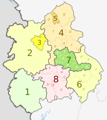
English: Map of the West Midlands region of England, showing its counties and administrative districts. The county colours are the same as those in File:English metropolitan and non-metropolitan counties 2009.svg.
Equirectangular map projection on WGS 84 datum, with N/S stretched 165% Geographic limits:
|
| 日期 | (UTC) |
| 來源 |
This file was derived from: |
| 作者 |
|
| Other versions |
 |


| Map | Ceremonial county | Shire county / unitary | Districts |
|---|---|---|---|
 |
1. Herefordshire U.A. | ||
| Shropshire | 2. Shropshire U.A. | ||
| 3. Telford and Wrekin U.A. | |||
| Staffordshire | 4. Staffordshire † | a) Cannock Chase, b) East Staffordshire, c) Lichfield, d) Newcastle-under-Lyme, e) South Staffordshire, f) Stafford, g) Staffordshire Moorlands, h) Tamworth | |
| 5. Stoke-on-Trent U.A. | |||
| 6. Warwickshire † | a) North Warwickshire, b) Nuneaton and Bedworth, c) Rugby, d) Stratford-on-Avon, e) Warwick | ||
| 7. West Midlands * | a) Birmingham, b) Coventry, c) Dudley, d) Sandwell, e) Solihull, f) Walsall, g) Wolverhampton | ||
| 8. Worcestershire † | a) Bromsgrove, b) Malvern Hills, c) Redditch, d) Worcester, e) Wychavon, f) Wyre Forest | ||
Key: †shire county | *metropolitan county
協議
呢個檔案用共享創意 姓名標示-非商業性-相同方式分享3.0 未本地化版本條款授權。
姓名標示: Dr Greg and Nilfanion. Contains Ordnance Survey data © Crown copyright and database right 2011
- 你可以:
- 去分享 – 複製、發佈同傳播呢個作品
- 再改 – 創作演繹作品
- 要遵照下面嘅條件:
- 署名 – 你一定要畀合適嘅表彰、畀返指向呢個授權條款嘅連結,同埋寫明有無改過嚟。你可以用任何合理方式去做,但唔可以用任何方式暗示授權人認可咗你或者你嘅使用方式。
- 相同方式分享 – 如果你用任何方式改過呢個作品,你必須要用返原本或者相似嘅條款發佈。
Original upload log
This image is a derivative work of the following images:
- File:West_Midlands_districts_2011_map.svg licensed with Cc-by-sa-3.0, GFDL
- 2011-05-01T19:06:46Z Nilfanion 1161x1306 (1392730 Bytes) == Summary == {{Information |Description=Map of the [[w:West Midlands|West Midlands]] region showing the administrative districts. Equirectangular map projection on WGS 84 datum, with N/S stretched 165% Geographic limits: *
- File:English_ceremonial_counties_2010.svg licensed with Cc-by-sa-3.0, GFDL
- 2010-11-23T16:39:55Z Nilfanion 1108x1345 (308868 Bytes) thicker lines
- 2010-11-23T16:20:19Z Nilfanion 1108x1345 (301520 Bytes) tweaks
- 2010-10-26T20:34:20Z Nilfanion 817x990 (1391832 Bytes) {{Information |Description=Map showing the [[w:ceremonial counties of England]] including the City of London, in 2010. Equirectangular map projection on WGS 84 datum, with N/S stretched 170% Geographic limits: *West: 6.75W
Uploaded with derivativeFX
檔案歷史
撳個日期/時間去睇響嗰個時間出現過嘅檔案。
| 日期/時間 | 縮圖 | 尺寸 | 用戶 | 註解 | |
|---|---|---|---|---|---|
| 現時 | 2012年5月5號 (六) 20:01 | | 1,161 × 1,306(1.38 MB) | Dr Greg | lighten black boundary line |
| 2012年5月2號 (三) 21:19 |  | 1,161 × 1,306(1.38 MB) | Dr Greg | == {{int:filedesc}} == {{Information |Description={{en|Map of the West Midlands region of England, showing its counties and administrative districts. The county colours are the same as those in [[:File:English metropolitan ... |
檔案用途
以下嘅1版用到呢個檔:
全域檔案使用情況
下面嘅維基都用緊呢個檔案:
- ar.wikipedia.org嘅使用情況
- de.wikipedia.org嘅使用情況
- en.wikipedia.org嘅使用情況
- fa.wikipedia.org嘅使用情況
- frr.wikipedia.org嘅使用情況
- fr.wikipedia.org嘅使用情況
- hr.wikipedia.org嘅使用情況
- hu.wikipedia.org嘅使用情況
- mr.wikipedia.org嘅使用情況
- pl.wikipedia.org嘅使用情況
- pnb.wikipedia.org嘅使用情況
- pt.wikipedia.org嘅使用情況
- th.wikipedia.org嘅使用情況
- tr.wikipedia.org嘅使用情況
- ur.wikipedia.org嘅使用情況
- vec.wikipedia.org嘅使用情況
- vi.wikipedia.org嘅使用情況
- vls.wikipedia.org嘅使用情況