
File:CapeHopeOverview.png

預覽大細:800 × 477 像素。 第啲解像度:320 × 191 像素|640 × 382 像素|907 × 541 像素。
原本檔案 (907 × 541 像素,檔案大細:59 KB ,MIME類型:image/png)
摘要
| 描述 |
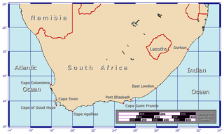
Afrikaans: Benamings van die kape aan die Suid-Afrikaanse kus
Generated using GMT. |
| 日期 | 2006年1月28號 (original upload date) |
| 來源 | 自己作品 |
| 作者 | Johantheghost |
協議
I, the copyright holder of this work, hereby publish it under the following licenses:

|
根據自由軟體基金會發佈嘅無固定段落、封面文字同封底文字GNU自由文件授權條款第1.2或打後嘅版本,你獲授權可以重製、散佈同埋修改爾份文件。授權條款嘅副本喺章節GNU自由文件授權條款。 |
| 呢個檔案用共享創意 姓名標示-非商業性-相同方式分享3.0 未本地化版本條款授權。 | ||
| ||
| This licensing tag was added to this file as part of the GFDL licensing update. |
This file is licensed under the Creative Commons Attribution-Share Alike 2.5 Generic, 2.0 Generic and 1.0 Generic license.
- 你可以:
- 去分享 – 複製、發佈同傳播呢個作品
- 再改 – 創作演繹作品
- 要遵照下面嘅條件:
- 署名 – 你一定要畀合適嘅表彰、畀返指向呢個授權條款嘅連結,同埋寫明有無改過嚟。你可以用任何合理方式去做,但唔可以用任何方式暗示授權人認可咗你或者你嘅使用方式。
- 相同方式分享 – 如果你用任何方式改過呢個作品,你必須要用返原本或者相似嘅條款發佈。
你可以揀你想用嘅牌照。
檔案歷史
撳個日期/時間去睇響嗰個時間出現過嘅檔案。
| 日期/時間 | 縮圖 | 尺寸 | 用戶 | 註解 | |
|---|---|---|---|---|---|
| 現時 | 2006年2月9號 (四) 12:23 | | 907 × 541(59 KB) | Johantheghost | Less violent colours. |
| 2006年1月29號 (日) 00:15 |  | 907 × 541(59 KB) | Johantheghost | Scale at last... | |
| 2006年1月28號 (六) 23:48 |  | 907 × 541(58 KB) | Johantheghost | ||
| 2006年1月28號 (六) 22:45 |  | 907 × 541(58 KB) | Johantheghost | A map showing the location of the Cape of Good Hope and Cape Agulhas. Generated using [http://gmt.soest.hawaii.edu/ GMT]. |
檔案用途
以下嘅1版用到呢個檔:
全域檔案使用情況
下面嘅維基都用緊呢個檔案:
- arc.wikipedia.org嘅使用情況
- ar.wikipedia.org嘅使用情況
- el.wikipedia.org嘅使用情況
- en.wikipedia.org嘅使用情況
- hu.wikipedia.org嘅使用情況
- ms.wikipedia.org嘅使用情況
- ro.wikipedia.org嘅使用情況
- sq.wikipedia.org嘅使用情況
- sr.wikipedia.org嘅使用情況