
File:2011 Tohoku earthquake observed tsunami heights.png

預覽大細:656 × 600 像素。 第啲解像度:263 × 240 像素|525 × 480 像素|700 × 640 像素。
原本檔案 (700 × 640 像素,檔案大細:299 KB ,MIME類型:image/png)
| 描述 |
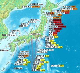
English: Map of 2011 Tohoku(Sendai) earthquake observed tsunami heights in Japan.
日本語: 東北地方太平洋沖地震で観測された、日本各地の津波の高さ。 |
| 日期 | |
| 來源 | JMA1, 2, 3, 4, map:demis |
| 作者 | own work |
| Other versions |
SVG再構成版が利用できます。(SVG version available) |
This image is in the public domain because it came from the site https://www.demis.nl/products/web-map-server/examples/ and was released by the copyright holder. Permission is granted to copy, distribute and/or modify this map since it is based on free of copyright images from: www.demis.nl. See also approval email on de.wp and its clarification.
|
| This work has been released into the public domain by its copyright holder, www.demis.nl. This applies worldwide. In some countries this may not be legally possible; if so: www.demis.nl grants anyone the right to use this work for any purpose, without any conditions, unless such conditions are required by law.
|
檔案歷史
撳個日期/時間去睇響嗰個時間出現過嘅檔案。
| 日期/時間 | 縮圖 | 尺寸 | 用戶 | 註解 | |
|---|---|---|---|---|---|
| 現時 | 2011年4月29號 (五) 10:47 | | 700 × 640(299 KB) | Pekachu | 相馬の津波高さ変更に伴う修正([http://www.jma.go.jp/jma/press/1104/13a/201104131600.html JMA press]) |
| 2011年4月2號 (六) 13:38 |  | 700 × 640(299 KB) | Pekachu | 着色間違いを訂正 | |
| 2011年4月2號 (六) 13:22 |  | 700 × 640(299 KB) | Pekachu | {{Information |Description ={{en|1=Map of 2011 Tohoku(Sendai) earthquake observed tsunami heights in Japan.}} {{ja|1=東北地方太平洋沖地震で観測された、日本各地の |
檔案用途
以下嘅1版用到呢個檔:
全域檔案使用情況
下面嘅維基都用緊呢個檔案:
- en.wikipedia.org嘅使用情況
- ja.wikipedia.org嘅使用情況
- ko.wikipedia.org嘅使用情況
- zh.wikipedia.org嘅使用情況