
File:Aralsea tmo 2014231 lrg.jpg
原本檔案 (2,000 × 2,000 像素,檔案大細:1.15 MB ,MIME類型:image/jpeg)
摘要
| 描述 |
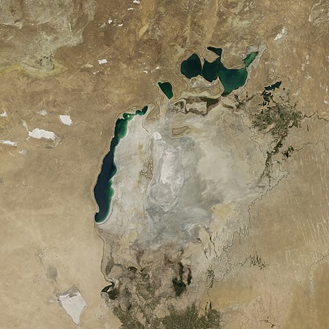
English: The remains of the Aral Sea on August 19, 2014 |
| 日期 | |
| 來源 | http://earthobservatory.nasa.gov/IOTD/view.php?id=84437 |
| 作者 | NASA |
| Camera location | | View this and other nearby images on: OpenStreetMap |
|---|
Shrinking of Aral Sea due to dessication.
協議
| This file is in the public domain in the United States because it was solely created by NASA. NASA copyright policy states that "NASA material is not protected by copyright unless noted". (See Template:PD-USGov, NASA copyright policy page or JPL Image Use Policy.) | ||
 |
Warnings:
|
檔案歷史
撳個日期/時間去睇響嗰個時間出現過嘅檔案。
| 日期/時間 | 縮圖 | 尺寸 | 用戶 | 註解 | |
|---|---|---|---|---|---|
| 現時 | 2014年9月27號 (六) 17:46 |  | 2,000 × 2,000(1.15 MB) | Farrukh89 | User created page with UploadWizard |
檔案用途
以下嘅1版用到呢個檔:
全域檔案使用情況
下面嘅維基都用緊呢個檔案:
- af.wikipedia.org嘅使用情況
- arz.wikipedia.org嘅使用情況
- ast.wikipedia.org嘅使用情況
- az.wikipedia.org嘅使用情況
- ba.wikipedia.org嘅使用情況
- be.wikipedia.org嘅使用情況
- bg.wikipedia.org嘅使用情況
- ca.wikipedia.org嘅使用情況
- de.wikipedia.org嘅使用情況
- el.wikipedia.org嘅使用情況
- en.wikipedia.org嘅使用情況
- en.wiktionary.org嘅使用情況
- es.wikipedia.org嘅使用情況
- et.wikipedia.org嘅使用情況
- eu.wikipedia.org嘅使用情況
- fa.wikipedia.org嘅使用情況
- hy.wikipedia.org嘅使用情況
- id.wikipedia.org嘅使用情況
- it.wikipedia.org嘅使用情況
- ka.wikipedia.org嘅使用情況
- kk.wikipedia.org嘅使用情況
- ko.wikipedia.org嘅使用情況
- lt.wikipedia.org嘅使用情況
- lv.wikipedia.org嘅使用情況
- no.wikipedia.org嘅使用情況
- pl.wikipedia.org嘅使用情況
- pt.wikipedia.org嘅使用情況
- ro.wikipedia.org嘅使用情況
- ru.wikipedia.org嘅使用情況
- simple.wikipedia.org嘅使用情況
- tr.wikipedia.org嘅使用情況
- uk.wikipedia.org嘅使用情況
- ur.wikipedia.org嘅使用情況
- uz.wikipedia.org嘅使用情況
睇呢個檔案嘅更多全域使用情況。