
File:Armenia map numbered.svg

呢個「SVG」檔案嘅呢個「PNG」預覽嘅大細:587 × 599 像素。 第啲解像度:235 × 240 像素|470 × 480 像素|752 × 768 像素|1,003 × 1,024 像素|2,006 × 2,048 像素|725 × 740 像素。
原本檔案 (SVG檔案,表面大細: 725 × 740 像素,檔案大細:86 KB)
摘要
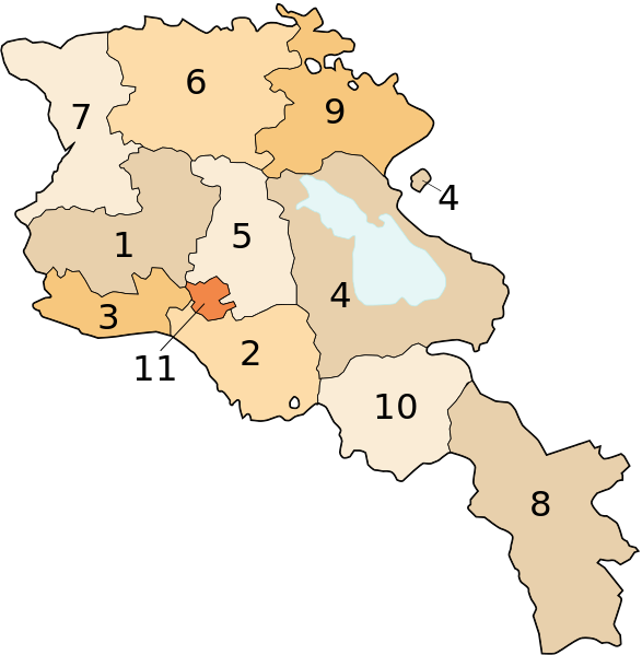
Image shows the eleven administrative subdivisions of Armenia:
- Aragatsotn (Արագածոտնի)
- Ararat (Արարատի)
- Armavir (Արմավիրի)
- Gegharkunik (Գեղարքունիքի)
- Kotayk (Կոտայքի)
- Lori (Լոռու)
- Shirak (Շիրակի)
- Syunik (Սյունիքի)
- Tavush (Տավուշի)
- Vayots Dzor (Վայոց Ձորի)
- Yerevan (Երևան) - special administrative status
Derived from a multiple of public sources and created using Inkscape.
協議

|
根據自由軟體基金會發佈嘅無固定段落、封面文字同封底文字GNU自由文件授權條款第1.2或打後嘅版本,你獲授權可以重製、散佈同埋修改爾份文件。授權條款嘅副本喺章節GNU自由文件授權條款。 |
| 呢個檔案用共享創意 姓名標示-非商業性-相同方式分享3.0 未本地化版本條款授權。 | ||
| ||
| This licensing tag was added to this file as part of the GFDL licensing update. |
檔案歷史
撳個日期/時間去睇響嗰個時間出現過嘅檔案。
| 日期/時間 | 縮圖 | 尺寸 | 用戶 | 註解 | |
|---|---|---|---|---|---|
| 現時 | 2013年10月13號 (日) 17:18 | | 725 × 740(86 KB) | Fry1989 | Per AN, this type of POV is improper and unacceptable |
| 2013年10月11號 (五) 20:06 |  | 725 × 740(80 KB) | Ankax Hayastan | Reverted to version as of 17:27, 26 September 2010 | |
| 2013年10月11號 (五) 20:00 |  | 725 × 740(86 KB) | Fry1989 | Revert political POV | |
| 2010年9月26號 (日) 17:27 |  | 725 × 740(80 KB) | Ankax Hayastan | Reverted to version as of 17:31, 25 November 2006 (((Exclaves deleted according to official map at http://www.gov.am/en/regions/))) | |
| 2006年11月25號 (六) 19:37 |  | 725 × 740(86 KB) | Bastique | Cleanup | |
| 2006年11月25號 (六) 19:26 |  | 725 × 740(84 KB) | Bastique | Enclaves | |
| 2006年11月25號 (六) 17:31 |  | 725 × 740(80 KB) | Bastique | Fixed canvas size | |
| 2006年11月25號 (六) 17:27 |  | 744 × 1,052(78 KB) | Bastique | Image shows the subdivisions of Armenia. Derived from a multiple of public sources and created using Inkscape. == Licensing == {{GFDL}} Image shows the eleven administrative subdivisions of Armenia: #Aragatsotn (Արագածոտնի) #[[Ararat (pr |
檔案用途
以下嘅1版用到呢個檔:
全域檔案使用情況
下面嘅維基都用緊呢個檔案:
- ast.wikipedia.org嘅使用情況
- avk.wikipedia.org嘅使用情況
- awa.wikipedia.org嘅使用情況
- az.wikipedia.org嘅使用情況
- az.wiktionary.org嘅使用情況
- be-tarask.wikipedia.org嘅使用情況
- be.wikipedia.org嘅使用情況
- bg.wikipedia.org嘅使用情況
- bn.wikipedia.org嘅使用情況
- bs.wikipedia.org嘅使用情況
- ca.wikipedia.org嘅使用情況
- cs.wikipedia.org嘅使用情況
- cy.wikipedia.org嘅使用情況
- el.wikipedia.org嘅使用情況
- en.wikipedia.org嘅使用情況
- eo.wikipedia.org嘅使用情況
- es.wikipedia.org嘅使用情況
- fa.wikipedia.org嘅使用情況
- fr.wikipedia.org嘅使用情況
- hi.wikipedia.org嘅使用情況
睇呢個檔案嘅更多全域使用情況。