
File:COVID-19 Outbreak Cases in New Zealand (DHB Totals).svg

呢個「SVG」檔案嘅呢個「PNG」預覽嘅大細:460 × 599 像素。 第啲解像度:184 × 240 像素|369 × 480 像素|590 × 768 像素|787 × 1,024 像素|1,573 × 2,048 像素|650 × 846 像素。
原本檔案 (SVG檔案,表面大細: 650 × 846 像素,檔案大細:138 KB)
.svg?uselang=yue)
摘要

|
This file may be updated to reflect new information. If you wish to use a specific version of the file without new updates being mirrored, please upload the required version as a separate file. |
| 描述 |
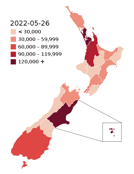
English: Map of the COVID-19 outbreak in New Zealand with case totals by District Health Board (DHB) as of 28 February 2022. Be aware that since this is a rapidly evolving situation, new cases may not be immediately represented visually. Refer to the primary article 2019–20 coronavirus outbreak by country and territory or the World Health Organization's situation reports for most recent reported case information.
The data ranges for each colour may be updated periodically to reflect changing data. Numerical ranges for each colour are calculated to give equally sized ranges. N.B: Stewart Island and Chatham Island are associated with the Southern DHB and Canterbury DHB (respectively). The colours for those islands represent the overall DHB case numbers, not the number of cases present on those islands specifically. |
| 日期 | |
| 來源 |
|
| 作者 |
Base map: Base map: Stats NZ, edits by Air55 Colourisation: multiple authors |
.svg)
協議
This file is licensed under the Creative Commons Attribution-Share Alike 4.0 International license.
- 你可以:
- 去分享 – 複製、發佈同傳播呢個作品
- 再改 – 創作演繹作品
- 要遵照下面嘅條件:
- 署名 – 你一定要畀合適嘅表彰、畀返指向呢個授權條款嘅連結,同埋寫明有無改過嚟。你可以用任何合理方式去做,但唔可以用任何方式暗示授權人認可咗你或者你嘅使用方式。
- 相同方式分享 – 如果你用任何方式改過呢個作品,你必須要用返原本或者相似嘅條款發佈。
檔案歷史
撳個日期/時間去睇響嗰個時間出現過嘅檔案。
.svg&dir=prev)
.svg&offset=20220129003640)
.svg&offset=&limit=20)
.svg&offset=&limit=50)
.svg&offset=&limit=100)
.svg&offset=&limit=250)
.svg&offset=&limit=500)
| 日期/時間 | 縮圖 | 尺寸 | 用戶 | 註解 | |
|---|---|---|---|---|---|
| 現時 | 2022年5月26號 (四) 03:55 | | 650 × 846(138 KB) | Air55 | Updated totals as of 26 May 2022 |
| 2022年4月3號 (日) 02:25 |  | 650 × 846(138 KB) | Air55 | updated totals as of 2 April 2022 | |
| 2022年3月17號 (四) 07:47 |  | 650 × 846(138 KB) | Air55 | updated totals | |
| 2022年3月8號 (二) 00:48 |  | 650 × 846(138 KB) | Air55 | case totals + scale update | |
| 2022年3月6號 (日) 02:16 |  | 650 × 846(138 KB) | Air55 | updated case totals | |
| 2022年3月2號 (三) 01:42 |  | 650 × 846(138 KB) | Air55 | updated ranges | |
| 2022年3月2號 (三) 01:09 |  | 650 × 846(138 KB) | Air55 | 02 March 2022 totals | |
| 2022年3月1號 (二) 04:43 |  | 650 × 846(138 KB) | Air55 | Redid map. Legend now features in map for ease of updating across all pages, colour bins updated | |
| 2022年3月1號 (二) 03:06 |  | 650 × 846(135 KB) | Air55 | updated as of 28 Feb. will be looking at making a new version of this map in light of the rapidly rising cases | |
| 2022年1月29號 (六) 00:36 |  | 650 × 846(135 KB) | Air55 | Updated case totals for 28 January 2022. Colours changed for BOP, Lakes, and Canterbury DHBs. |
檔案用途
以下嘅1版用到呢個檔:
全域檔案使用情況
下面嘅維基都用緊呢個檔案:
- de.wikipedia.org嘅使用情況
- en.wikipedia.org嘅使用情況
- es.wikipedia.org嘅使用情況
- fa.wikipedia.org嘅使用情況
- fr.wikipedia.org嘅使用情況
- he.wikipedia.org嘅使用情況
- id.wikipedia.org嘅使用情況
- ko.wikipedia.org嘅使用情況
- ms.wikipedia.org嘅使用情況
- nl.wikipedia.org嘅使用情況
- ru.wikipedia.org嘅使用情況
- simple.wikipedia.org嘅使用情況
- sq.wikipedia.org嘅使用情況
- th.wikipedia.org嘅使用情況
- uk.wikipedia.org嘅使用情況
- uz.wikipedia.org嘅使用情況
- vi.wikipedia.org嘅使用情況
- zh.wikipedia.org嘅使用情況
.svg)