
File:Canada geological map.JPG
原本檔案 (2,000 × 1,557 像素,檔案大細:2.25 MB ,MIME類型:image/jpeg)

|
This geology image could be recreated using vector graphics as an SVG file. This has several advantages; see Commons:Media for cleanup for more information. If an SVG form of this image is already available, please upload it. After uploading an SVG, replace this template with {{vector version available|new image name.svg}}.
|


摘要
| 描述 |
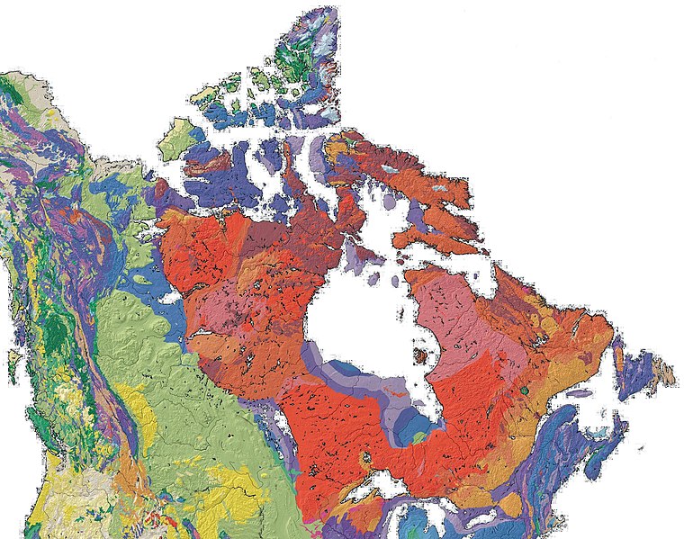
English: Geological Map of Canada |
| 日期 | |
| 來源 | en:File:North america with-Williston.jpg, PD - USGS |
| 作者 | Qyd |
協議
| I, the copyright holder of this work, release this work into the public domain. This applies worldwide. In some countries this may not be legally possible; if so: I grant anyone the right to use this work for any purpose, without any conditions, unless such conditions are required by law. |
檔案歷史
撳個日期/時間去睇響嗰個時間出現過嘅檔案。
| 日期/時間 | 縮圖 | 尺寸 | 用戶 | 註解 | |
|---|---|---|---|---|---|
| 現時 | 2009年3月6號 (五) 16:23 |  | 2,000 × 1,557(2.25 MB) | Qyd | {{Information |Description={{en|1=Geological Map of Canada}} |Source=File:North america with-Williston.jpg, PD - USGS |Author=Qyd |Date=2009 |Permission= |other_versions= }} Category:Maps of Canada <!--{{ImageUpload|full}}--> |
檔案用途
以下嘅1版用到呢個檔:
全域檔案使用情況
下面嘅維基都用緊呢個檔案:
- be.wikipedia.org嘅使用情況
- bg.wikipedia.org嘅使用情況
- bn.wikipedia.org嘅使用情況
- bs.wikipedia.org嘅使用情況
- cs.wikipedia.org嘅使用情況
- de.wikipedia.org嘅使用情況
- en.wikipedia.org嘅使用情況
- en.wikiversity.org嘅使用情況
- en.wikivoyage.org嘅使用情況
- fa.wikipedia.org嘅使用情況
- fr.wikipedia.org嘅使用情況
- gcr.wikipedia.org嘅使用情況
- he.wikipedia.org嘅使用情況
- he.wiktionary.org嘅使用情況
- hu.wikipedia.org嘅使用情況
- id.wikipedia.org嘅使用情況
- ja.wikipedia.org嘅使用情況
- pl.wikipedia.org嘅使用情況
- ru.wikipedia.org嘅使用情況
- sh.wikipedia.org嘅使用情況
- simple.wikipedia.org嘅使用情況
- sk.wikipedia.org嘅使用情況
- uk.wikipedia.org嘅使用情況
- zh.wikipedia.org嘅使用情況