
File:Canton1860.jpg

原本檔案 (11,680 × 6,672 像素,檔案大細:11.72 MB ,MIME類型:image/jpeg)
| 警告 | 原文件像素好高。開full size來睇個話,個文件未必正常load到,或者會令你個瀏覽器死機。想避免呢個問題,可以用ZoomViewer。 |
|---|
摘要
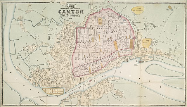
| Description |
English: "Map of the City and Entire Suburbs of Canton in 1860 by Rev. D. Vrooman", an updating of Vrooman's 1855 map of the city, incorporating the destruction of the Thirteen Factories, the erection of Shamian, and minor adjustments to his prospective map of the city following its opening to foreign visitors following the treaties of Tianjin and Beijing.
中文(简体):广州市1860年地图,藏于澳洲国家图书馆。
中文(繁體):廣州市1860年地圖,藏於澳洲國家圖書館。 |
||||||||||||||||
| 日期 | |||||||||||||||||
| 來源 | http://www.nla.gov.au/apps/cdview/nla.map-lms636 | ||||||||||||||||
| Creator |
|
||||||||||||||||
| Geotemporal data | |||||||||||||||||
| Bounding box |
|
||||||||||||||||
| Georeferencing | |||||||||||||||||
| Other versions | |||||||||||||||||

協議
|
呢個作品喺來源國同埋其他版權期限係作者過身後100年或以下嘅國家同地區屬於公有領域。 | |
| This file has been identified as being free of known restrictions under copyright law, including all related and neighboring rights. | |
檔案歷史
撳個日期/時間去睇響嗰個時間出現過嘅檔案。
| 日期/時間 | 縮圖 | 尺寸 | 用戶 | 註解 | |
|---|---|---|---|---|---|
| 現時 | 2018年1月17號 (三) 14:25 | | 11,680 × 6,672(11.72 MB) | User-duck | Cropped using CropTool with lossless mode. |
| 2011年8月24號 (三) 10:34 |  | 11,952 × 7,536(13.97 MB) | Gzdavidwong | {{Information |Description ={{en|1=Maps of Canton City in 1860.}} {{zh-hans|1=广州市1860年地图。}} {{zh-hant|1=廣州市1860年地圖。}} |Source ={{own}} |Author =Gzdavidwong |Date =1860 |Permissi |
檔案用途
以下嘅2版用到呢個檔:
全域檔案使用情況
下面嘅維基都用緊呢個檔案:
- en.wikipedia.org嘅使用情況
- fr.wikipedia.org嘅使用情況
- ha.wikipedia.org嘅使用情況
- ja.wikipedia.org嘅使用情況
- mai.wikipedia.org嘅使用情況
- ne.wikipedia.org嘅使用情況
- ru.wikipedia.org嘅使用情況
- www.wikidata.org嘅使用情況
- zh.wikipedia.org嘅使用情況