
File:Carte du Mitanni.png

預覽大細:800 × 534 像素。 第啲解像度:320 × 214 像素|640 × 427 像素|1,024 × 683 像素|1,272 × 849 像素。
原本檔案 (1,272 × 849 像素,檔案大細:1.51 MB ,MIME類型:image/png)
| 描述 |
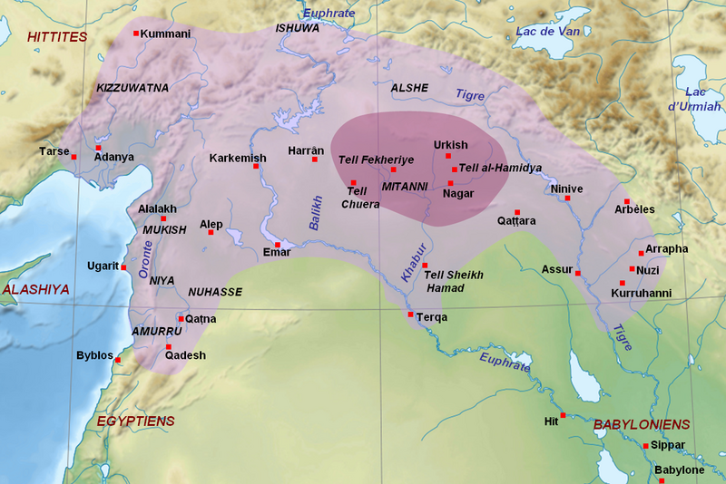
English: Map of the kingdom of Mitanni at its maximal extension, with the main cities and archaeological sites. Adapted from F. Joannès (dir.), Dictionnaire de la civilisation mésopotamienne, Paris, 2001, p. 534 (map by M. Sauvage and B. Lion), and M. Roaf, Cultural Atlas of Mesopotamia and the Ancient Near East, Oxford, 2004, p. 134 with the addition of Terqa among the vassals of Mitanni. Dark purple : the mitannian heartland ; light purple : the approximate maximal extension of the mitannian dominion.
Français : Carte du royaume du Mitanni avec ses limites approximatives à son apogée avec les principales villes et sites archéologiques. Adapté de F. Joannès (dir.), Dictionnaire de la civilisation mésopotamienne, Paris, 2001, p. 534 (carte de M. Sauvage et B. Lion), et M. Roaf, Cultural Atlas of Mesopotamia and the Ancient Near East, Oxford, 2004, p. 134, avec l'ajout de Terqa parmi les vassaux du Mitanni. Mauve foncé : le cœur du Mitanni ; mauve clair : les limites approximatives de l'extension maximale de la domination du Mitanni au début du XVe siècle av. J.-C. |
| 日期 | (UTC) |
| 來源 | |
| 作者 |
|
| Other versions |
[]
|


| This is a retouched picture, which means that it has been digitally altered from its original version. Modifications: Ajout des sites du Mitanni et de l'étendue du royaume. The original can be viewed here: Near East topographic map-blank.svg:
|
I, the copyright holder of this work, hereby publish it under the following licenses:
This file is licensed under the Creative Commons Attribution-Share Alike 3.0 Unported, 2.5 Generic, 2.0 Generic and 1.0 Generic license.
- 你可以:
- 去分享 – 複製、發佈同傳播呢個作品
- 再改 – 創作演繹作品
- 要遵照下面嘅條件:
- 署名 – 你一定要畀合適嘅表彰、畀返指向呢個授權條款嘅連結,同埋寫明有無改過嚟。你可以用任何合理方式去做,但唔可以用任何方式暗示授權人認可咗你或者你嘅使用方式。
- 相同方式分享 – 如果你用任何方式改過呢個作品,你必須要用返原本或者相似嘅條款發佈。

|
根據自由軟體基金會發佈嘅無固定段落、封面文字同封底文字GNU自由文件授權條款第1.2或打後嘅版本,你獲授權可以重製、散佈同埋修改爾份文件。授權條款嘅副本喺章節GNU自由文件授權條款。 |
你可以揀你想用嘅牌照。
Original upload log
This image is a derivative work of the following images:
- File:Near_East_topographic_map-blank.svg licensed with Cc-by-sa-3.0,2.5,2.0,1.0, GFDL
- 2009-08-18T18:31:37Z Sémhur 2425x1581 (2442670 Bytes) 3 - New try
- 2009-08-17T15:39:22Z Sémhur 2425x1581 (1815374 Bytes) 2 - With the background...
- 2009-08-17T15:37:36Z Sémhur 2425x1581 (2836 Bytes) {{Information |Description={{en|1=Blank physical map of the [[:en:Near East|Near East]]}} {{fr|1=Carte physique vierge du [[:fr:Proche-Orient|Proche-Orient]].}} |Source={{own}} |Author=[[User:Sémhur|Sémhur]] |Date=2008-08-1
Uploaded with derivativeFX
檔案歷史
撳個日期/時間去睇響嗰個時間出現過嘅檔案。
| 日期/時間 | 縮圖 | 尺寸 | 用戶 | 註解 | |
|---|---|---|---|---|---|
| 現時 | 2010年9月23號 (四) 14:00 | | 1,272 × 849(1.51 MB) | Zunkir | Ajout de Qattara, corrections mineures. |
| 2010年9月23號 (四) 13:57 |  | 1,272 × 849(1.51 MB) | Zunkir | Coloriage de l'extension du Mitanni, et de sa région centrale, ajout de villes et des noms des cours d'eau. | |
| 2010年9月21號 (二) 11:49 |  | 1,173 × 797(1.42 MB) | Zunkir | {{Information |Description={{en|1=Map of the kingdom of Mitanni at its maximal extension, with the main cities and archeological sites.}} {{fr|Carte du royaume du Mitanni à son apogée avec les principales villes et sites archéologiques.}} |Source=*[[: |
檔案用途
以下嘅1版用到呢個檔:
全域檔案使用情況
下面嘅維基都用緊呢個檔案:
- am.wikipedia.org嘅使用情況
- ar.wikipedia.org嘅使用情況
- arz.wikipedia.org嘅使用情況
- ast.wikipedia.org嘅使用情況
- ba.wikipedia.org嘅使用情況
- be-tarask.wikipedia.org嘅使用情況
- bg.wikipedia.org嘅使用情況
- bn.wikipedia.org嘅使用情況
- br.wikipedia.org嘅使用情況
- ceb.wikipedia.org嘅使用情況
- ckb.wikipedia.org嘅使用情況
- cs.wikipedia.org嘅使用情況
- de.wikipedia.org嘅使用情況
- el.wikipedia.org嘅使用情況
- en.wikipedia.org嘅使用情況
- eo.wikipedia.org嘅使用情況
- fa.wikipedia.org嘅使用情況
- fi.wikipedia.org嘅使用情況
- fr.wikipedia.org嘅使用情況
- gl.wikipedia.org嘅使用情況
- hi.wikipedia.org嘅使用情況
- id.wikipedia.org嘅使用情況
- it.wikipedia.org嘅使用情況
- ja.wikipedia.org嘅使用情況
- lt.wikipedia.org嘅使用情況
- lv.wikipedia.org嘅使用情況
- ne.wikipedia.org嘅使用情況
- nl.wikipedia.org嘅使用情況
睇呢個檔案嘅更多全域使用情況。