
File:ElectoralCollege2016.svg

呢個「SVG」檔案嘅呢個「PNG」預覽嘅大細:800 × 465 像素。 第啲解像度:320 × 186 像素|640 × 372 像素|1,024 × 595 像素|1,280 × 744 像素|2,560 × 1,488 像素|1,020 × 593 像素。
原本檔案 (SVG檔案,表面大細: 1,020 × 593 像素,檔案大細:30 KB)
| U.S. presidential election maps (SVG) |
| See also: National Atlas maps (png) |
|
1789 · 1792 · 1796 · 1800 · 1804 · 1808 · 1812 · 1816 · 1820 · 1824 · 1828 · 1832 · 1836 · 1840 · 1844 · 1848 · 1852 · 1856 · 1860 · 1864 · 1868 · 1872 · 1876 · 1880 · 1884 · 1888 · 1892 · 1896 · 1900 · 1904 · 1908 · 1912 · 1916 · 1920 · 1924 · 1928 · 1932 · 1936 · 1940 · 1944 · 1948 · 1952 · 1956 · 1960 · 1964 · 1968 · 1972 · 1976 · 1980 · 1984 · 1988 · 1992 · 1996 · 2000 · 2004 · 2008 · 2012 · 2016 · 2020 · 2024 |
摘要
| 描述 |
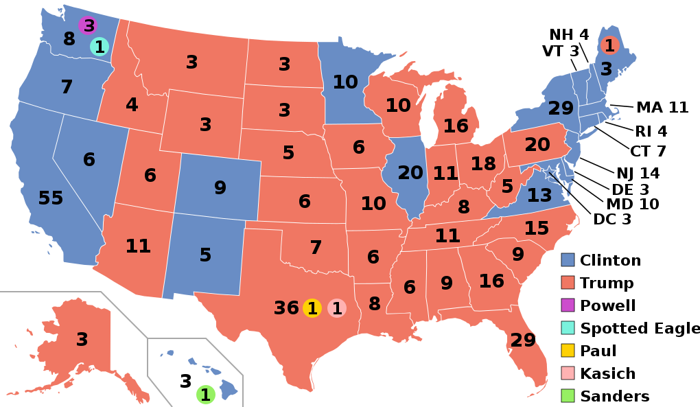
English: Electoral college map for the 2016 United States presidential election (note: Nebraska and Maine split their EVs by congressional district). |
||||
| 日期 | |||||
| 來源 | 2012 Electoral College map | ||||
| 作者 | Gage | ||||
| Other versions |
|
||||
| SVG genesis |

.svg)


.svg)
.svg)


協議
This file is licensed under the Creative Commons Attribution-Share Alike 4.0 International license.
- 你可以:
- 去分享 – 複製、發佈同傳播呢個作品
- 再改 – 創作演繹作品
- 要遵照下面嘅條件:
- 署名 – 你一定要畀合適嘅表彰、畀返指向呢個授權條款嘅連結,同埋寫明有無改過嚟。你可以用任何合理方式去做,但唔可以用任何方式暗示授權人認可咗你或者你嘅使用方式。
- 相同方式分享 – 如果你用任何方式改過呢個作品,你必須要用返原本或者相似嘅條款發佈。
檔案歷史
撳個日期/時間去睇響嗰個時間出現過嘅檔案。
| 日期/時間 | 縮圖 | 尺寸 | 用戶 | 註解 | |
|---|---|---|---|---|---|
| 現時 | 2020年11月27號 (五) 03:22 | | 1,020 × 593(30 KB) | Politicsfan4 | Updated placement of ME-2's electoral vote for consistency with 2020 map |
| 2020年8月5號 (三) 01:22 |  | 1,020 × 593(30 KB) | Nojus R | Reverted to version as of 07:42, 13 January 2019 (UTC) it looks so weird when every other map uses a different font | |
| 2019年12月10號 (二) 19:31 |  | 1,020 × 593(30 KB) | IagoQnsi | switching font to Arial, as it looks less-ugly in the server-side rendering // Editing SVG source code using c:User:Rillke/SVGedit.js | |
| 2019年1月13號 (日) 07:42 |  | 1,020 × 593(30 KB) | Newfraferz87 | (minor) | |
| 2018年11月20號 (二) 02:50 |  | 1,020 × 593(30 KB) | Newfraferz87 | *DC | |
| 2018年11月20號 (二) 02:35 |  | 1,020 × 593(30 KB) | Newfraferz87 | Simplify further: coordinates & fills, following this | |
| 2017年1月18號 (三) 14:16 |  | 1,020 × 593(36 KB) | Newfraferz87 | Shrink size using relative line coordinates. Thanks for the border corrections. | |
| 2017年1月17號 (二) 09:20 |  | 1,020 × 593(43 KB) | Karlfk | Better borderlines, esp. OH/WV/PA triangle or ID/MT border | |
| 2017年1月12號 (四) 03:14 |  | 1,020 × 593(36 KB) | PalmerTheGolfer | Reverted to version as of 00:56, 3 January 2017 (UTC) Font of numbers and State line consistency with prior elections more important than a non-existent Libretarian faithless elector change | |
| 2017年1月10號 (二) 22:50 |  | 1,020 × 593(36 KB) | Maproom | Changed font to Liberation Sans, in the hope of avoiding the problem of "Eagle" extending off the end of the image |
.svg)
檔案用途
以下嘅1版用到呢個檔:
全域檔案使用情況
下面嘅維基都用緊呢個檔案:
- af.wikipedia.org嘅使用情況
- ang.wikipedia.org嘅使用情況
- ar.wikipedia.org嘅使用情況
- arz.wikipedia.org嘅使用情況
- be.wikipedia.org嘅使用情況
- bg.wikipedia.org嘅使用情況
- bn.wikipedia.org嘅使用情況
- bs.wikipedia.org嘅使用情況
- ca.wikipedia.org嘅使用情況
- cdo.wikipedia.org嘅使用情況
- cs.wikipedia.org嘅使用情況
- cy.wikipedia.org嘅使用情況
- da.wikipedia.org嘅使用情況
- de.wikipedia.org嘅使用情況
- dty.wikipedia.org嘅使用情況
- el.wikipedia.org嘅使用情況
- en.wikipedia.org嘅使用情況
- Donald Trump
- Electoral vote changes between United States presidential elections
- List of United States presidential election results by state
- Presidency of Barack Obama
- 2016 United States presidential election
- United States presidential election
- 2016 Democratic Party presidential candidates
- 2016 Democratic Party presidential primaries
- 2016 Republican Party presidential candidates
- 2016 Republican Party presidential primaries
- Third party and independent candidates for the 2016 United States presidential election
- 2016 United States elections
- User:ArcMachaon/sandbox
- User:Mandruss/sandbox
- User:Visigoethe/sandbox
睇呢個檔案嘅更多全域使用情況。