
File:Europe subregion map UN geoscheme.svg

呢個「SVG」檔案嘅呢個「PNG」預覽嘅大細:680 × 520 像素。 第啲解像度:314 × 240 像素|628 × 480 像素|1,004 × 768 像素|1,280 × 979 像素|2,560 × 1,958 像素。
原本檔案 (SVG檔案,表面大細: 680 × 520 像素,檔案大細:228 KB)
摘要
| 描述 |
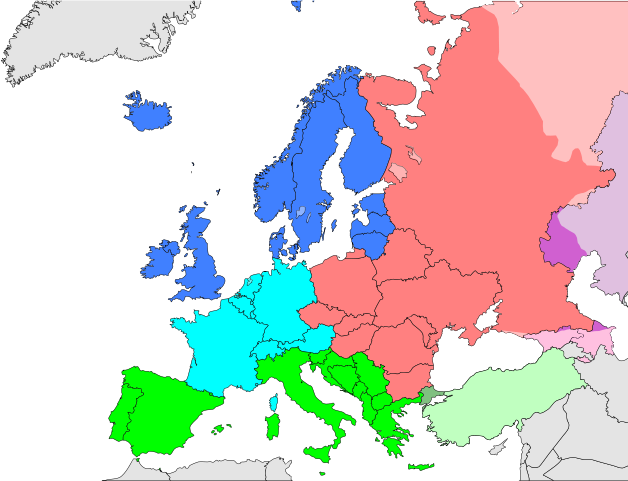
Deutsch: Subregionen Europas (nach UN Geoschema)
Nordeuropa
Westeuropa
Osteuropa
Südeuropa English: Subregions of Europe (UN geoscheme)
Northern Europe
Western Europe
Eastern Europe
Southern Europe
Countries of West Asia with partial territory in Southern Europe: Turkey
Countries of West Asia with partial territory in Eastern Europe: Georgia and Azerbaijan
Countries of Central Asia with partial territory in Eastern Europe: Kazakhstan
Русский: Макрорегионы Европы (классификация ООН)
Северная Европа
Западная Европа
Восточная Европа
Южная Европа
Страны макрорегиона Западная Азия с частичной территорией в Южной Европе: Турция
Страны макрорегиона Западная Азия с частичной территорией в Восточной Европе: Азербайджан и Грузия
Страны макрорегиона Центральная Азия с частичной территорией в Восточной Европе: Казахстан
Українська: Підрегіони Європи (класифікація Організації Об’єднаних Націй)
Північна Європа
Західна Європа
Східна Європа
Південна Європа |
| 日期 | |
| 來源 | 自己作品 |
| 作者 | Kolja21 |
| Other versions |
Derivative works of this file:
|


_de.png)
.png)


協議
我,呢份作品嘅作者,決定用以下許可發佈呢件作品:
Ĉi tiu dosiero estas disponebla laŭ la permesilo Krea Komunaĵo Atribuite 3.0 Neadaptita.
- 你可以:
- 去分享 – 複製、發佈同傳播呢個作品
- 再改 – 創作演繹作品
- 要遵照下面嘅條件:
- 署名 – 你一定要畀合適嘅表彰、畀返指向呢個授權條款嘅連結,同埋寫明有無改過嚟。你可以用任何合理方式去做,但唔可以用任何方式暗示授權人認可咗你或者你嘅使用方式。
檔案歷史
撳個日期/時間去睇響嗰個時間出現過嘅檔案。
| 日期/時間 | 縮圖 | 尺寸 | 用戶 | 註解 | |
|---|---|---|---|---|---|
| 現時 | 2021年11月9號 (二) 13:50 | | 680 × 520(228 KB) | TU-nor | Reverted to version as of 12:17, 22 February 2021 (UTC) No reason to color countries that are outside Europe in the Geosceme unless they are geographically transcontinental |
| 2021年8月6號 (五) 00:12 |  | 680 × 520(262 KB) | Vesperius | Cleanup at the edges. | |
| 2021年8月5號 (四) 23:53 |  | 680 × 520(238 KB) | Vesperius | Cyprus and Armenia included. | |
| 2021年2月22號 (一) 12:17 |  | 680 × 520(228 KB) | TU-nor | Andorra is Southern Europe in UN geoscheme | |
| 2015年9月23號 (三) 11:17 |  | 680 × 520(572 KB) | Alex Great | Reverted to version as of 09:22, 1 June 2014 | |
| 2015年7月10號 (五) 09:48 |  | 744 × 1,052(430 KB) | Andrej500 | Crimea | |
| 2014年6月1號 (日) 09:22 |  | 680 × 520(572 KB) | Insider | Russian Sochi Sector in Asia | |
| 2009年5月27號 (三) 18:50 |  | 680 × 520(571 KB) | Kolja21 | {{Information |Description={{en|1=Subregions of Europe (UN geoschme)}} {{de|1=Subregionen Europas (nach UN Geoschema)}} |Source=Eigenes Werk (own work) |Author=Kolja21 |Date=2009-05-23 |Permission= |other_ |
檔案用途
以下嘅1版用到呢個檔:
全域檔案使用情況
下面嘅維基都用緊呢個檔案:
- af.wikipedia.org嘅使用情況
- am.wikipedia.org嘅使用情況
- ar.wikipedia.org嘅使用情況
- av.wikipedia.org嘅使用情況
- awa.wikipedia.org嘅使用情況
- azb.wikipedia.org嘅使用情況
- ba.wikipedia.org嘅使用情況
- be.wikipedia.org嘅使用情況
- bn.wikipedia.org嘅使用情況
- br.wikipedia.org嘅使用情況
- ce.wikipedia.org嘅使用情況
- cs.wikipedia.org嘅使用情況
- cv.wikipedia.org嘅使用情況
- cy.wikipedia.org嘅使用情況
- de.wikipedia.org嘅使用情況
- diq.wikipedia.org嘅使用情況
- el.wikipedia.org嘅使用情況
- en.wikipedia.org嘅使用情況
睇呢個檔案嘅更多全域使用情況。