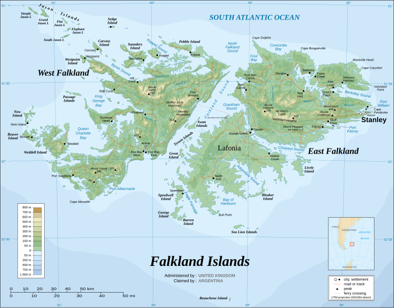
File:Falkland Islands topographic map-en.svg
頁面內容唔支援其他語言。
出自維基百科,自由嘅百科全書

原本檔案(SVG檔案,表面大細: 2,550 × 1,990 像素,檔案大細:1.97 MB)

 
  This SVG map uses required raster graphics to show delicate structures.
圖 of the year
圖 of the year
Featured 圖

維基同享維基百科

This file was a candidate in Picture of the Year 2007.
This is a featured picture on Wikimedia Commons (特色靚相) and is considered one of the finest images. See its nomination here.

 This is a featured picture on the English language Wikipedia (Featured pictures) and is considered one of the finest images. See its nomination here.

If you have an image of similar quality that can be published under a suitable copyright license, be sure to upload it, tag it, and nominate it.


Pour agrandir l'image

Detailed map of large dimension. For a better viewing, click on the link of the image above.
Carte détaillée de grande dimension. Pour une visualisation optimale, cliquer sur le lien de l'image ci-dessus.

摘要

Description
English: The Falkland Islands are an archipelago in the South Atlantic Ocean, located 300 miles off the coast of Argentina. They consist of two main islands, East Falkland and West Falkland, together with about 700 smaller islands. Stanley, on East Falkland, is the capital and largest city. The islands are a self-governing Overseas Territory of the United Kingdom.
Français : Carte topographique en anglais des Îles Malouines. Les Malouines forment un archipel dans l'Océan Atlantique Sud à 480 km des côtes argentines. Il est composé de deux îles principales, East Falkland et West Falkland, et de 700 autres îles et îlots. Stanley, sur East Falkland, est la capitale et la plus grande agglomération de l'archipel. Les Malouines sont un territoire autonome du Royaume-Uni.
Nederlands: Topografische kaart van de Falklandeilanden, een Brits overzees gebiedsdeel in de Zuidelijke Atlantische Oceaan. De archipel bestaat uit twee hoofdeilanden en ongeveer 700 kleinere op ongeveer 300 kilometer uit de kust van Argentinië. Stanley op het eiland 'East Falkland' is de hoofdstad en tergelijkertijd de meest bevolkte gemeente van het eilandengroep.De eilanden zijn een 'self-governing Overseas Territory' van het Verenigd Koninkrijk van Groot-Brittannië en Noord-Ierland.
Português: Mapa topográfico (em inglês) das Ilhas Malvinas, um arquipélago no sul do Oceano Atlântico, a 300 milhas da costa da Argentina. Consiste de duas ilhas, Soledad a leste e Gran Malvina, a oeste, junto com cerca de 700 outras ilhotas. A capital (e maior cidade) é Stanley. As Malvinas são um território autónomo do Reino Unido.
SVG genesis
InfoField
 
The SVG code is valid.
 
This map was created with Inkscape.
{| cellspacing="8" cellpadding="0" style="clear:both; width:100%; margin:0.5em auto; border:2px solid #88A; background-color:#F7F8FF;" lang="en" dir="ltr"

|align="center"|Translate this file |width="100%"| This SVG file contains embedded text that can be translated into your language, using any capable SVG editor, text editor or the SVG Translate tool. For more information see: About translating SVG files.

|}
日期 November 2007 using elements from the original version of April 2007
來源 Own work ;
Topographic map : NASA Shuttle Radar Topography Mission (SRTM3 v.2) (public domain) edited with dlgv32 Pro/Global Mapper and vectorized with Inkscape ; UTM projection ; WGS84 datum ; shaded relief (composite image of N-W, W and N lightning positions) ;
Approximate scale of topographic data and shore / lakes limits : 1:705,000 ; of the bathymetry : 1:3.720.000
Bathymetry : USGov public domain data provided by the Demis add-on for World Wind (see the approval e-mail) ;
Other references used for additional data :
* UK government map ;
* NASA World Wind ;
* CIA map available on the site of the University of Texas at Austin ;
* Microsoft Encarta atlas (1999 edition).
Note : The shaded relief is a raster image embedded in the SVG file which increases its size. If you want a lighter map for other purposes, delete the shaded relief image in your file.
Creator
Eric Gaba (Sting - fr:Sting)
許可
(重用呢個檔案)
Attribution and Share-Alike required
Georeferencing Georeference the map in Wikimaps Warper If inappropriate please set warp_status = skip to hide.
Other versions

Derivative works of this file:

[]


協議

I, the copyright holder of this work, hereby publish it under the following licenses:
GNU head 根據自由軟體基金會發佈嘅無固定段落、封面文字同封底文字GNU自由文件授權條款第1.2或打後嘅版本,你獲授權可以重製、散佈同埋修改爾份文件。授權條款嘅副本喺章節GNU自由文件授權條款
w:en:Creative Commons
署名 相同方式分享
呢個檔案用共享創意 姓名標示-非商業性-相同方式分享3.0 未本地化版本條款授權。
你可以:
  • 去分享 – 複製、發佈同傳播呢個作品
  • 再改 – 創作演繹作品
要遵照下面嘅條件:
  • 署名 – 你一定要畀合適嘅表彰、畀返指向呢個授權條款嘅連結,同埋寫明有無改過嚟。你可以用任何合理方式去做,但唔可以用任何方式暗示授權人認可咗你或者你嘅使用方式。
  • 相同方式分享 – 如果你用任何方式改過呢個作品,你必須要用返原本或者相似嘅條款發佈。
This licensing tag was added to this file as part of the GFDL licensing update.
w:en:Creative Commons
署名 相同方式分享
This file is licensed under the Creative Commons Attribution-Share Alike 2.5 Generic, 2.0 Generic and 1.0 Generic license.
你可以:
  • 去分享 – 複製、發佈同傳播呢個作品
  • 再改 – 創作演繹作品
要遵照下面嘅條件:
  • 署名 – 你一定要畀合適嘅表彰、畀返指向呢個授權條款嘅連結,同埋寫明有無改過嚟。你可以用任何合理方式去做,但唔可以用任何方式暗示授權人認可咗你或者你嘅使用方式。
  • 相同方式分享 – 如果你用任何方式改過呢個作品,你必須要用返原本或者相似嘅條款發佈。
你可以揀你想用嘅牌照。

Captions

Add a one-line explanation of what this file represents

Items portrayed in this file

圖中顯示嘅係

image/svg+xml

檔案歷史

撳個日期/時間去睇響嗰個時間出現過嘅檔案。

最近最舊) 睇【新10次】【102050100250500
日期/時間縮圖尺寸用戶註解
現時2021年8月23號 (一) 02:51響2021年8月23號 (一) 02:51嘅縮圖版本2,550 × 1,990(1.97 MB)Praça de MaioFile uploaded using svgtranslate tool (https://svgtranslate.toolforge.org/). Added translation for tr.
2021年8月23號 (一) 02:50響2021年8月23號 (一) 02:50嘅縮圖版本2,550 × 1,990(1.97 MB)Praça de MaioFile uploaded using svgtranslate tool (https://svgtranslate.toolforge.org/). Added translation for tr.
2017年4月6號 (四) 11:54響2017年4月6號 (四) 11:54嘅縮圖版本2,550 × 1,990(1.91 MB)RaviC+ New Haven Ferry
2008年12月19號 (五) 18:38響2008年12月19號 (五) 18:38嘅縮圖版本2,550 × 1,990(1.93 MB)StingReverted to version as of 03:38, 14 November 2007: please upload the translated version under a specific name
2008年12月19號 (五) 18:26響2008年12月19號 (五) 18:26嘅縮圖版本2,550 × 1,990(1.93 MB)Vitekthis is just croatian translation
2007年11月14號 (三) 03:38響2007年11月14號 (三) 03:38嘅縮圖版本2,550 × 1,990(1.93 MB)StingNew version more accurate and with shaded relief
2007年6月16號 (六) 01:18響2007年6月16號 (六) 01:18嘅縮圖版本2,550 × 1,990(1.03 MB)StingReverted to earlier revision
2007年6月16號 (六) 01:03響2007年6月16號 (六) 01:03嘅縮圖版本2,550 × 1,990(2.14 MB)StingTrying to fix the bug on WP-en #8
2007年6月16號 (六) 00:40響2007年6月16號 (六) 00:40嘅縮圖版本2,550 × 1,990(2.01 MB)StingTrying to fix the bug on WP-en #7 (really boring...)
2007年6月16號 (六) 00:29響2007年6月16號 (六) 00:29嘅縮圖版本2,550 × 1,990(2.08 MB)StingTrying to fix the bug on WP-en #6 (OK, the problem comes from the shaded relief raster image)
最近最舊) 睇【新10次】【102050100250500

以下嘅1版用到呢個檔:

全域檔案使用情況

下面嘅維基都用緊呢個檔案:

睇呢個檔案嘅更多全域使用情況

Metadata