
File:Geoga Bridge map.png
預覽大細:800 × 437 像素。 第啲解像度:320 × 175 像素|640 × 350 像素|1,041 × 569 像素。
原本檔案 (1,041 × 569 像素,檔案大細:122 KB ,MIME類型:image/png)
摘要
| 描述 |
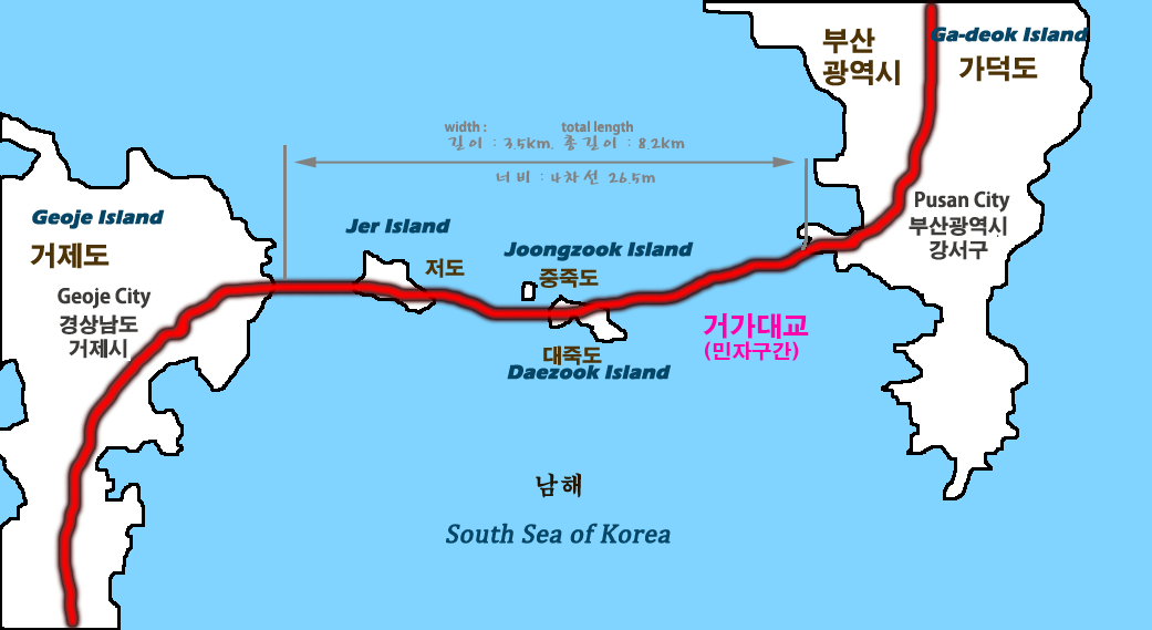
English: Map of Busan–Geoje Fixed Link roadway bridge-tunnel system |
||
| 日期 | |||
| 來源 | ko:파일:거가대교 지도.png | ||
| 作者 | self-made | ||
| Other versions |
|

| Object location | | View this and other nearby images on: OpenStreetMap |
|---|
協議
| I, the copyright holder of this work, release this work into the public domain. This applies worldwide. In some countries this may not be legally possible; if so: I grant anyone the right to use this work for any purpose, without any conditions, unless such conditions are required by law. |
檔案歷史
撳個日期/時間去睇響嗰個時間出現過嘅檔案。
| 日期/時間 | 縮圖 | 尺寸 | 用戶 | 註解 | |
|---|---|---|---|---|---|
| 現時 | 2010年11月10號 (三) 11:19 | | 1,041 × 569(122 KB) | Asfreeas | {{Information |Description=Map of newly made Geoga Bridge |Source=http://ko.wikipedia.org/wiki/%ED%8C%8C%EC%9D%BC:%EA%B1%B0%EA%B0%80%EB%8C%80%EA%B5%90_%EC%A7%80%EB%8F%84.png |Date=2010-11-10 |Author=self-made |Permission=see below |other_versions= }} [[C |
檔案用途
以下嘅1版用到呢個檔:
全域檔案使用情況
下面嘅維基都用緊呢個檔案:
- cs.wikipedia.org嘅使用情況
- de.wikipedia.org嘅使用情況
- en.wikipedia.org嘅使用情況
- fr.wikipedia.org嘅使用情況
- ja.wikipedia.org嘅使用情況
- nl.wikipedia.org嘅使用情況
- no.wikipedia.org嘅使用情況
- www.wikidata.org嘅使用情況
- zh.wikipedia.org嘅使用情況