
File:Great Lakes bathymetry map.png
原本檔案 (1,024 × 731 像素,檔案大細:1.34 MB ,MIME類型:image/png)
摘要
| 描述 |
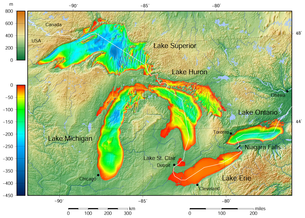
English: Great Lakes bathymetry and surrounding area shaded relief map. Lakes are contoured with interval 100 m. Lake Superior is incomplete. |
| 日期 | |
| 來源 |
Own work using: the following Public Domain datasets (grids):
The color palette of the depth scale was made to be more or less similar to the color palettes used on the NGDC Great Lakes maps. |
| 作者 | Darekk2 using the Great Lakes Bathymetry and GLOBE tiles |
| Other versions |
|

協議
Attribution (in addition to the author of this map):
The NGDC in it's copyright notice says:
As required by 17 U.S.C. 403, third parties producing copyrighted works consisting predominantly of the material produced by U.S. government agencies must provide notice with such work(s) identifying the U.S. Government material incorporated and stating that such material is not subject to copyright protection within the United States. (...)
(for credits see the Source section).
and Great Lakes Bathymetry and GLOBE
(see above and the Source section)
- 你可以:
- 去分享 – 複製、發佈同傳播呢個作品
- 再改 – 創作演繹作品
- 要遵照下面嘅條件:
- 署名 – 你一定要畀合適嘅表彰、畀返指向呢個授權條款嘅連結,同埋寫明有無改過嚟。你可以用任何合理方式去做,但唔可以用任何方式暗示授權人認可咗你或者你嘅使用方式。
- 相同方式分享 – 如果你用任何方式改過呢個作品,你必須要用返原本或者相似嘅條款發佈。
檔案歷史
撳個日期/時間去睇響嗰個時間出現過嘅檔案。
| 日期/時間 | 縮圖 | 尺寸 | 用戶 | 註解 | |
|---|---|---|---|---|---|
| 現時 | 2015年5月9號 (六) 15:46 | | 1,024 × 731(1.34 MB) | Darekk2 | more accurate shorelines, the lakes tiles better assembled, added Canada, USA and Lake St. Clair labels, moved Detroit label, Michigan Lake - retouched western part of Green Bay |
| 2015年3月25號 (三) 10:03 |  | 1,024 × 731(1.34 MB) | Darekk2 | changed illumination for shaded relief | |
| 2015年3月25號 (三) 01:29 |  | 1,024 × 731(1.33 MB) | Darekk2 | changed palette a little | |
| 2015年3月24號 (二) 20:21 |  | 1,024 × 731(1.61 MB) | Darekk2 | User created page with UploadWizard |
檔案用途
以下嘅1版用到呢個檔:
全域檔案使用情況
下面嘅維基都用緊呢個檔案:
- ar.wikipedia.org嘅使用情況
- en.wikipedia.org嘅使用情況
- fi.wikipedia.org嘅使用情況
- ja.wikipedia.org嘅使用情況
- nl.wikipedia.org嘅使用情況
- sr.wikipedia.org嘅使用情況
- tt.wikipedia.org嘅使用情況
- uk.wikipedia.org嘅使用情況
- vep.wikipedia.org嘅使用情況
- www.wikidata.org嘅使用情況