
File:Haiti-2010-quake.png
冇更高解像度嘅圖像。
Haiti-2010-quake.png (326 × 350 像素,檔案大細:37 KB ,MIME類型:image/png)
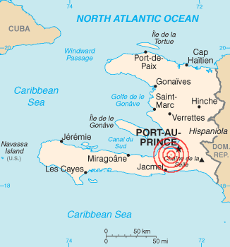
| 描述 | 2010 Haiti earthquake epicenter | |||
| 日期 | ||||
| 來源 | English Wikipedia, based on [1] with location info from [2]. | |||
| 作者 | Based on U.S. govt work, rings added by Evercat | |||
| 許可 (重用呢個檔案) |
|
|||
| Other versions | File:Haiti_map.png |

![[1]](https://en.wikipedia.org/wiki/File:Haiti_map.png)
檔案歷史
撳個日期/時間去睇響嗰個時間出現過嘅檔案。
| 日期/時間 | 縮圖 | 尺寸 | 用戶 | 註解 | |
|---|---|---|---|---|---|
| 現時 | 2010年1月13號 (三) 00:26 | | 326 × 350(37 KB) | Warko | {{Information |Description=2010 Haiti earthquake |Source=[http://en.wikipedia.org/wiki/File:Haiti-2010-quake.png English Wikipedia], based on [http://neic.usgs.gov/neis/bulletin/neic_rja6_l.html]. |Date= 12 January 2010 |Author=Based on U.S. govt work, ri |
檔案用途
以下嘅1版用到呢個檔:
全域檔案使用情況
下面嘅維基都用緊呢個檔案:
- ar.wikipedia.org嘅使用情況
- bg.wikinews.org嘅使用情況
- bs.wikipedia.org嘅使用情況
- ckb.wikipedia.org嘅使用情況
- cs.wikipedia.org嘅使用情況
- cy.wikipedia.org嘅使用情況
- da.wikipedia.org嘅使用情況
- de.wikipedia.org嘅使用情況
- de.wikinews.org嘅使用情況
- en.wikipedia.org嘅使用情況
- eo.wikipedia.org嘅使用情況
- et.wikipedia.org嘅使用情況
- fa.wikipedia.org嘅使用情況
- fi.wikipedia.org嘅使用情況
- fi.wikinews.org嘅使用情況
- fr.wikipedia.org嘅使用情況
- fr.wikinews.org嘅使用情況
- Haïti : important séisme de magnitude 7
- Haïti : la mission de l'ONU assure la sécurité après le séisme
- Haïti : 7 500 soldats américains supplémentaires attendus
- Haïti : l'aide humanitaire toujours confrontée aux problèmes logistiques
- Haïti : fin des opérations de recherche de survivants
- 5,3 milliards de dollars pour la reconstruction d'Haïti
- gd.wikipedia.org嘅使用情況
- hi.wikipedia.org嘅使用情況
- hr.wikipedia.org嘅使用情況
- is.wikipedia.org嘅使用情況
- mg.wikipedia.org嘅使用情況
- mr.wikipedia.org嘅使用情況
- ms.wikipedia.org嘅使用情況
- my.wikipedia.org嘅使用情況
- nds.wikipedia.org嘅使用情況
- pl.wikinews.org嘅使用情況
- pt.wikipedia.org嘅使用情況
- ro.wikipedia.org嘅使用情況
- ro.wikinews.org嘅使用情況
- sh.wikipedia.org嘅使用情況
- sr.wikipedia.org嘅使用情況
- sv.wikipedia.org嘅使用情況
- szl.wikipedia.org嘅使用情況
- tl.wikipedia.org嘅使用情況
- tr.wikipedia.org嘅使用情況
睇呢個檔案嘅更多全域使用情況。