
File:Location greek ancient.png
冇更高解像度嘅圖像。
Location_greek_ancient.png (248 × 113 像素,檔案大細:4 KB ,MIME類型:image/png)
摘要
| 描述 |
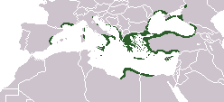
English: Locator map depicting the ancient Greek world, c. 550 BC |
|||
| 日期 | ||||
| 來源 | Self-created, after http://www.wwnorton.com/nrl/english/nawol/maps/MAP7GRCO.JPG | |||
| 作者 | User:ChrisO | |||
| 許可 (重用呢個檔案) |
|
|||
| Other versions |
|


檔案歷史
撳個日期/時間去睇響嗰個時間出現過嘅檔案。
| 日期/時間 | 縮圖 | 尺寸 | 用戶 | 註解 | |
|---|---|---|---|---|---|
| 現時 | 2021年9月27號 (一) 16:20 | | 248 × 113(4 KB) | Deji Olajide1999 | Added the missing regions of Orestis, Elimiotis, Eordaia and Tymphaea + cleared up the Greek colonies in Thrace. |
| 2018年1月23號 (二) 09:22 |  | 248 × 113(4 KB) | Maphobbyist | Added Colchis. | |
| 2014年6月26號 (四) 16:15 |  | 248 × 113(6 KB) | SilentResident | Added missing kingdom of Epirus | |
| 2012年12月29號 (六) 10:55 |  | 248 × 113(5 KB) | Gepgepgep | Aggiunta l'area di colonizzazione greca dell'Adriatico, che mancava completamente | |
| 2011年9月5號 (一) 17:22 |  | 248 × 113(5 KB) | Spesh531 | Showing borders that are recognized. Still showing unrecognized countries for a reference of where Ancient Greek was. It was also about the shape of the lands, as Greek Islands where either not shown correctly or not there at all | |
| 2011年9月5號 (一) 13:00 |  | 248 × 113(4 KB) | Maphobbyist | Pfrevious user Saguamundi is right. International borders, and NOT disputed borders must be shown. Nor is this about the present but about historical Greek settlements. There is no place for current politics for a historical map. | |
| 2011年9月4號 (日) 22:28 |  | 248 × 113(5 KB) | Spesh531 | Reverted to version as of 01:56, 11 May 2011 The border were fine, your showing territories where some are unrecognizable | |
| 2011年9月4號 (日) 22:21 |  | 248 × 113(5 KB) | Spesh531 | Reverted to version as of 01:56, 11 May 2011 The border were fine, your showing territories where some are unrecognizable | |
| 2011年9月4號 (日) 21:26 |  | 248 × 113(4 KB) | Saguamundi | Same map but with internationally recognized borders. | |
| 2011年5月11號 (三) 01:56 |  | 248 × 113(5 KB) | Spesh531 | update more to source, the current Greece was not under territory. |
檔案用途
無嘢連來呢份檔案。
全域檔案使用情況
下面嘅維基都用緊呢個檔案:
- en.wikipedia.org嘅使用情況
- pl.wikibooks.org嘅使用情況