
File:Major Indo-Aryan languages.png
冇更高解像度嘅圖像。
Major_Indo-Aryan_languages.png (572 × 599 像素,檔案大細:303 KB ,MIME類型:image/png)
摘要
| 描述 |
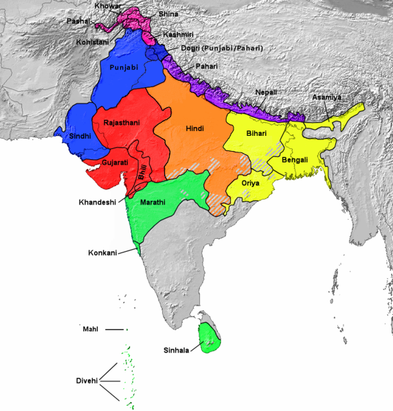
Français : Aires de répartition des principales langues indo-aryennes (carte de 1978). L'ourdou n'est pas représenté séparément du hindi. English: 1978 map showing Geographical distribution of the major Indo-Aryan languages. The western part is Proto-Indo-Europeans[1] (not shown in this map) including Medes, Persians, and Parthians [2] and Eastern Part (Urdu is included under Hindi. Romani, Domari, and Lomavren are outside the scope of the map.) Dotted/striped areas indicate where multilingualism is common.
|
||
| 日期 | |||
| 來源 | https://upload.wikimedia.org/wikipedia/commons/archive/0/0f/20151007205526!Indoarische_Sprachen_Gruppen.png | ||
| 作者 | Filpro | ||
| Other versions |
This file was derived from: Indoarische Sprachen Gruppen.png
|

協議
Ĉi tiu dosiero estas disponebla laŭ la permesilo Krea Komunaĵo Atribuite 3.0 Neadaptita.
- 你可以:
- 去分享 – 複製、發佈同傳播呢個作品
- 再改 – 創作演繹作品
- 要遵照下面嘅條件:
- 署名 – 你一定要畀合適嘅表彰、畀返指向呢個授權條款嘅連結,同埋寫明有無改過嚟。你可以用任何合理方式去做,但唔可以用任何方式暗示授權人認可咗你或者你嘅使用方式。
- ↑ https://en.wikipedia.org/wiki/Proto-Indo-Iranian_language
- ↑ https://en.wikipedia.org/wiki/History_of_Iran#Early_Iron_Age
檔案歷史
撳個日期/時間去睇響嗰個時間出現過嘅檔案。
| 日期/時間 | 縮圖 | 尺寸 | 用戶 | 註解 | |
|---|---|---|---|---|---|
| 現時 | 2023年7月28號 (五) 07:12 | | 572 × 599(303 KB) | PadFoot2008 | |
| 2023年7月27號 (四) 08:41 |  | 572 × 599(303 KB) | PadFoot2008 | Corrected lines based on correct linguistic classifications instead of social ones. | |
| 2022年9月20號 (二) 04:40 |  | 572 × 599(307 KB) | Zhamidz | Reverted to version as of 16:55, 27 February 2018 (UTC). The map is different | |
| 2021年9月17號 (五) 09:47 |  | 500 × 500(75 KB) | Amritsvāraya | changed the map into a more accurate map | |
| 2018年2月27號 (二) 16:55 |  | 572 × 599(307 KB) | Mr rnddude | Bihari isn't a subset of the Hindi languages. Maithili is a language in its own right. | |
| 2017年10月29號 (日) 00:45 |  | 877 × 919(583 KB) | फ़िलप्रो | Reverted to version as of 04:41, 6 June 2016 (UTC) Updated map will be a separate image. | |
| 2017年10月27號 (五) 05:25 |  | 877 × 919(594 KB) | फ़िलप्रो | Updated boundaries based off of Ethnologue, Central-Eastern and Central-Western borders changed. Fixed unnamed region between Kashmiri, Dogri, and Pahari. | |
| 2016年6月6號 (一) 04:41 |  | 877 × 919(583 KB) | फ़िलप्रो | Southern Zone | |
| 2016年6月6號 (一) 04:24 |  | 877 × 919(580 KB) | फ़िलप्रो | Clean up. Corrections. | |
| 2016年1月12號 (二) 03:29 |  | 877 × 919(573 KB) | फ़िलप्रो | colours and specified groupings |
檔案用途
以下嘅1版用到呢個檔:
全域檔案使用情況
下面嘅維基都用緊呢個檔案:
- af.wikipedia.org嘅使用情況
- as.wikipedia.org嘅使用情況
- azb.wikipedia.org嘅使用情況
- az.wikipedia.org嘅使用情況
- ban.wikipedia.org嘅使用情況
- bh.wikipedia.org嘅使用情況
- bn.wikipedia.org嘅使用情況
- bs.wikipedia.org嘅使用情況
- da.wikipedia.org嘅使用情況
- en.wikipedia.org嘅使用情況
- Bhil languages
- Khas people
- Goaria language
- Malvi language
- Judeo-Marathi
- Dramatic Prakrit
- Shauraseni Prakrit
- Pardhi language
- Vlax Romani language
- Gamit language
- Danwar language
- Romani language standardization
- Brajavali dialect
- South Asian ethnic groups
- Shekhawati language
- Luwati language
- Ushoji language
- Dhundari language
- Abahattha
- Pashayi languages
- Shumashti language
- Sanskritism
- Sansi language
- Welsh Romani language
- Halbi language
- Kharia Thar language
- Nahari language
- Nangalami language
- Lubanki dialect
- Brokskat
- Old Hindi
- Finnish Kalo language
- Vasavi language
- Chit (consciousness)
- Tatparya
- Kadodi language
- Andh language
睇呢個檔案嘅更多全域使用情況。