
File:Map Gotthard-Basistunnel.png
原本檔案 (2,535 × 3,268 像素,檔案大細:7.64 MB ,MIME類型:image/png)
摘要
| Description |
Deutsch: Karte des Gotthard-Basistunnels, Schweiz
Alemannisch: Charte vom Gotthard-Basistunnel, Schwiz
Français : Carte de la tunnel de base du Saint-Gothard, Suisse
Italiano: Mappa della galleria di base del San Gottardo, Svizzera
Nederlands: Kaart van de Gotthard-basistunnel, Zwitserland
Rumantsch: Charta dal tunnel da basa dal Son Gottard, Svizra |
|||||||||
| 日期 | ||||||||||
| 來源 |
Map was created using:
|
|||||||||
| Creator |
|
|||||||||
| 許可 (重用呢個檔案) |
Map data (c) OpenStreetMap (and) contributors, CC-BY-SA | |||||||||
| Geotemporal data | ||||||||||
| Bounding box |
|
|||||||||
| Georeferencing | ||||||||||
| Other versions |
|
|||||||||


協議
This file is licensed under the Creative Commons Attribution-Share Alike 2.0 Generic license.
- 你可以:
- 去分享 – 複製、發佈同傳播呢個作品
- 再改 – 創作演繹作品
- 要遵照下面嘅條件:
- 署名 – 你一定要畀合適嘅表彰、畀返指向呢個授權條款嘅連結,同埋寫明有無改過嚟。你可以用任何合理方式去做,但唔可以用任何方式暗示授權人認可咗你或者你嘅使用方式。
- 相同方式分享 – 如果你用任何方式改過呢個作品,你必須要用返原本或者相似嘅條款發佈。
| This work is licensed under the Open Database License (summary). |
檔案歷史
撳個日期/時間去睇響嗰個時間出現過嘅檔案。
| 日期/時間 | 縮圖 | 尺寸 | 用戶 | 註解 | |
|---|---|---|---|---|---|
| 現時 | 2017年1月1號 (日) 10:22 | 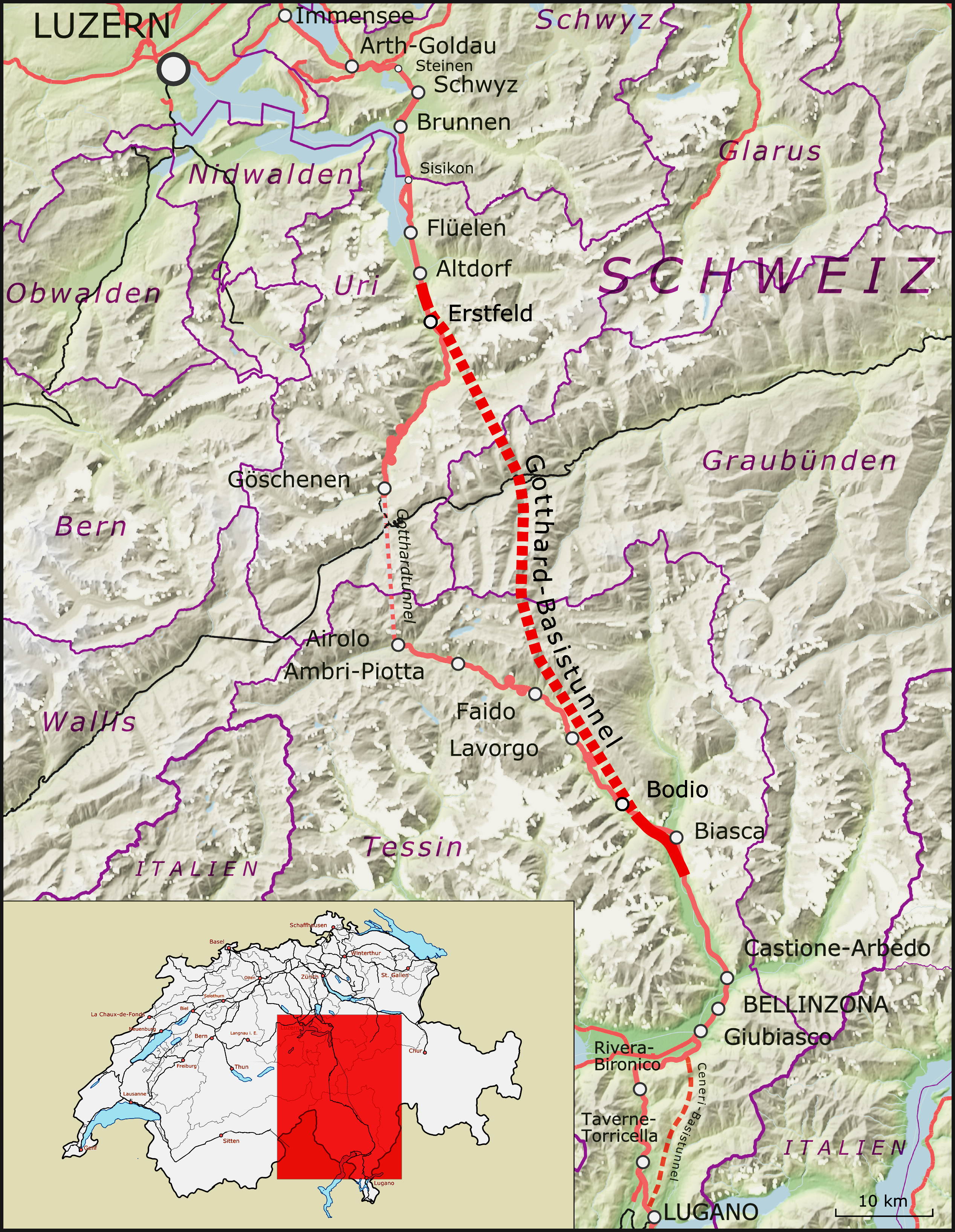 | 2,535 × 3,268(7.64 MB) | Antonsusi | try it again |
| 2017年1月1號 (日) 10:20 |  | 2,535 × 3,268(7.32 MB) | Antonsusi | Adjusting brightness | |
| 2016年12月26號 (一) 11:26 |  | 2,535 × 3,268(7.32 MB) | Pechristener | location map larger and updated to the 2016 version showing the GBT | |
| 2016年12月26號 (一) 11:07 |  | 2,535 × 3,268(7.77 MB) | Pechristener | original map adapted to the new desired format, red border of location map removed, strange border color replaced and scale added | |
| 2016年12月19號 (一) 15:12 |  | 2,500 × 3,250(8.16 MB) | Antonsusi | adjusting rect | |
| 2016年11月1號 (二) 16:56 |  | 2,500 × 3,250(8.17 MB) | Antonsusi | Adjusting red square | |
| 2016年11月1號 (二) 11:28 |  | 2,500 × 3,250(6.57 MB) | Antonsusi | Less upright size makes the use easier. Therefore: Environment of low interest cropped. Small map moved to the edge of low interest. | |
| 2016年10月15號 (六) 07:24 |  | 2,702 × 6,264(12.61 MB) | Pechristener | very small correction in the North East Corenr of the base map | |
| 2016年10月15號 (六) 07:03 |  | 2,702 × 6,264(12.61 MB) | Pechristener | == {{int:filedesc}} == {{Map |Description = {{de|1=Karte des Gotthard-Basistunnels in der Schweiz}} {{als|1=Charte vom Gotthard-Basistunnel}} {{fr|1=Carte de la [[:fr:Tunnel de base du Saint... |
檔案用途
以下嘅1版用到呢個檔:
全域檔案使用情況
下面嘅維基都用緊呢個檔案:
- bg.wikipedia.org嘅使用情況
- bn.wikipedia.org嘅使用情況
- ca.wikipedia.org嘅使用情況
- cy.wikipedia.org嘅使用情況
- de.wikipedia.org嘅使用情況
- en.wikipedia.org嘅使用情況
- es.wikipedia.org嘅使用情況
- et.wikipedia.org嘅使用情況
- fi.wikipedia.org嘅使用情況
- fr.wikipedia.org嘅使用情況
- it.wikipedia.org嘅使用情況
- ja.wikipedia.org嘅使用情況
- nl.wikipedia.org嘅使用情況
- nn.wikipedia.org嘅使用情況
- simple.wikipedia.org嘅使用情況
- sr.wikipedia.org嘅使用情況
- sv.wikipedia.org嘅使用情況
- tr.wikipedia.org嘅使用情況
- vi.wikipedia.org嘅使用情況
- www.wikidata.org嘅使用情況