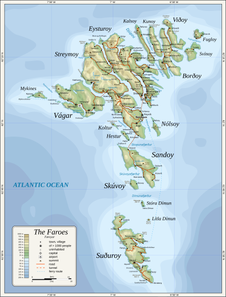
File:Map of the Faroe Islands en.svg

呢個「SVG」檔案嘅呢個「PNG」預覽嘅大細:457 × 600 像素。 第啲解像度:183 × 240 像素|366 × 480 像素|585 × 768 像素|780 × 1,024 像素|1,561 × 2,048 像素|1,683 × 2,208 像素。
原本檔案 (SVG檔案,表面大細: 1,683 × 2,208 像素,檔案大細:763 KB)
檔案歷史
撳個日期/時間去睇響嗰個時間出現過嘅檔案。
| 日期/時間 | 縮圖 | 尺寸 | 用戶 | 註解 | |
|---|---|---|---|---|---|
| 現時 | 2024年2月11號 (日) 20:53 |  | 1,683 × 2,208(763 KB) | Mysid | 'Multiply' blend mode didn't work - trying with alpha channel. |
| 2024年2月11號 (日) 20:34 |  | 1,683 × 2,208(733 KB) | Mysid | Added new 2023 tunnel, new names of some villages, fixed mistakes and svg errors, details | |
| 2010年7月19號 (一) 09:18 |  | 1,683 × 2,208(539 KB) | Mysid | oops, legend missing | |
| 2010年7月19號 (一) 09:16 |  | 1,683 × 2,208(539 KB) | Mysid | better choices for fonts | |
| 2009年1月28號 (三) 19:22 |  | 1,683 × 2,208(694 KB) | Mysid | remove ext. images | |
| 2009年1月28號 (三) 19:21 |  | 1,683 × 2,208(694 KB) | Mysid | embed all rasters | |
| 2009年1月28號 (三) 18:52 |  | 1,683 × 2,208(653 KB) | Mysid | {{Information |Description={{en|1=Topographic map of the Faroe Islands.}} |Source=Own work by uploader |Author=Mysid |Date=2009-01-28 |Permission= |other_versions= }} <!--{{ImageUpload|full}}--> Category:Maps of the Faroe Islands |
檔案用途
以下嘅1版用到呢個檔:
全域檔案使用情況
下面嘅維基都用緊呢個檔案:
- bg.wikipedia.org嘅使用情況
- bn.wikipedia.org嘅使用情況
- dsb.wikipedia.org嘅使用情況
- el.wikipedia.org嘅使用情況
- en.wikipedia.org嘅使用情況
- es.wikipedia.org嘅使用情況
- fa.wikipedia.org嘅使用情況
- fi.wikipedia.org嘅使用情況
- fo.wikipedia.org嘅使用情況
- frr.wikipedia.org嘅使用情況
- fr.wikipedia.org嘅使用情況
- ga.wikipedia.org嘅使用情況
- hu.wikipedia.org嘅使用情況
- ia.wikipedia.org嘅使用情況
- is.wikipedia.org嘅使用情況
- it.wikipedia.org嘅使用情況
- ka.wikipedia.org嘅使用情況
- kk.wikipedia.org嘅使用情況
- ko.wikipedia.org嘅使用情況
- lb.wikipedia.org嘅使用情況
- lez.wikipedia.org嘅使用情況
- mi.wikipedia.org嘅使用情況
- mk.wikipedia.org嘅使用情況
- nl.wikipedia.org嘅使用情況
- ru.wikipedia.org嘅使用情況
- scn.wikipedia.org嘅使用情況
- sco.wikipedia.org嘅使用情況
- sc.wikipedia.org嘅使用情況
- sr.wikipedia.org嘅使用情況
- sv.wikipedia.org嘅使用情況
睇呢個檔案嘅更多全域使用情況。

