
File:MidasSehri.Tomb.jpg
原本檔案 (2,023 × 1,398 像素,檔案大細:272 KB ,MIME類型:image/jpeg)
摘要
| 描述 | Midas Tomb at the archeological site Midas City (Midas Şehri). The site is in the village of Yazilikaya, midway between Eskişehir and Afyon. See also a close-up of the inscription. The relief is 17 meters high and dates from the 6th century BC. |
| 日期 | |
| 來源 | 自己作品 |
| 作者 | User:China_Crisis |
| 許可 (重用呢個檔案) |
[1] |
| Camera location | | View this and other nearby images on: OpenStreetMap |
|---|
協議
我,呢份作品嘅作者,決定用以下許可發佈呢件作品:
This file is licensed under the Creative Commons Attribution-Share Alike 2.5 Generic license.
- 你可以:
- 去分享 – 複製、發佈同傳播呢個作品
- 再改 – 創作演繹作品
- 要遵照下面嘅條件:
- 署名 – 你一定要畀合適嘅表彰、畀返指向呢個授權條款嘅連結,同埋寫明有無改過嚟。你可以用任何合理方式去做,但唔可以用任何方式暗示授權人認可咗你或者你嘅使用方式。
- 相同方式分享 – 如果你用任何方式改過呢個作品,你必須要用返原本或者相似嘅條款發佈。
檔案歷史
撳個日期/時間去睇響嗰個時間出現過嘅檔案。
| 日期/時間 | 縮圖 | 尺寸 | 用戶 | 註解 | |
|---|---|---|---|---|---|
| 現時 | 2006年5月31號 (三) 14:36 | 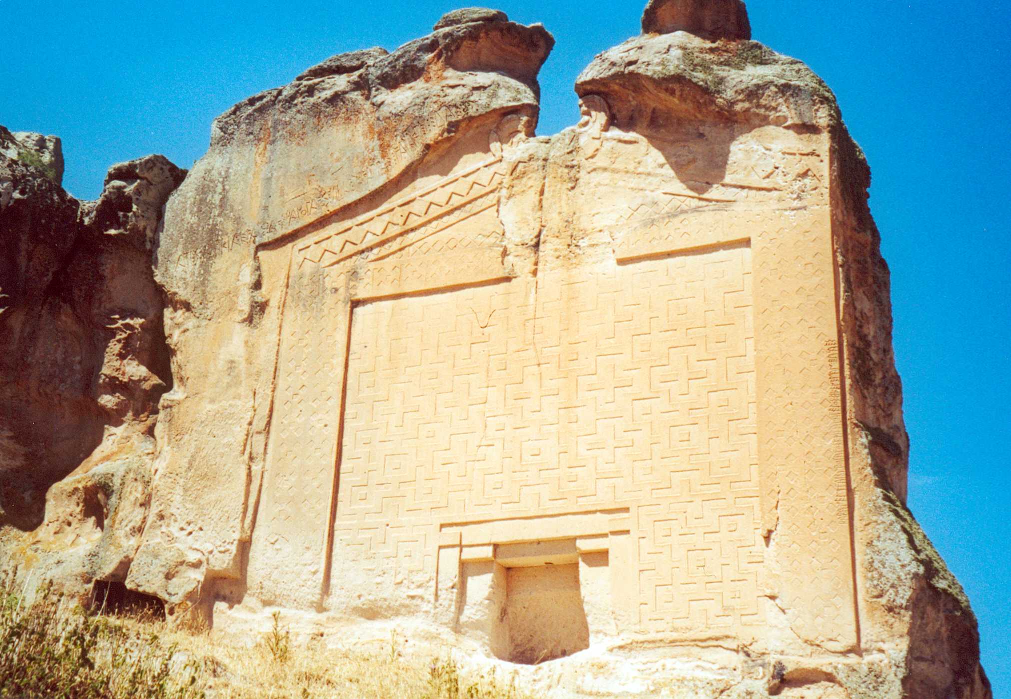 | 2,023 × 1,398(272 KB) | China Crisis |
檔案用途
以下嘅1版用到呢個檔:
全域檔案使用情況
下面嘅維基都用緊呢個檔案:
- af.wikipedia.org嘅使用情況
- ar.wikipedia.org嘅使用情況
- az.wikipedia.org嘅使用情況
- be-tarask.wikipedia.org嘅使用情況
- be.wikipedia.org嘅使用情況
- ca.wikipedia.org嘅使用情況
- ce.wikipedia.org嘅使用情況
- crh.wikipedia.org嘅使用情況
- de.wikipedia.org嘅使用情況
- diq.wikipedia.org嘅使用情況
- dsb.wikipedia.org嘅使用情況
- en.wikipedia.org嘅使用情況
- Midas
- Phrygians
- Eskişehir Province
- Rock-cut architecture
- Han, Eskişehir
- Talk:Rock-cut architecture
- Phrygia
- Rock-cut tomb
- Tentative list of World Heritage Sites in Turkey
- Yazılı, Han
- Phrygian Way
- User:SomeGuyWhoRandomlyEdits/List of rulers in the Mediterranean sea region during antiquity
- User:SomeGuyWhoRandomlyEdits/List of Greek mythological rulers (by tribe)
- es.wikipedia.org嘅使用情況
- fa.wikipedia.org嘅使用情況
- fr.wikipedia.org嘅使用情況
- hy.wikipedia.org嘅使用情況
- it.wikipedia.org嘅使用情況
- ja.wikipedia.org嘅使用情況
- ka.wikipedia.org嘅使用情況
- mk.wikipedia.org嘅使用情況
- nl.wikipedia.org嘅使用情況
- nn.wikipedia.org嘅使用情況
- no.wikipedia.org嘅使用情況
- pl.wikipedia.org嘅使用情況
睇呢個檔案嘅更多全域使用情況。