
File:National-atlas-louisiana.png
冇更高解像度嘅圖像。
National-atlas-louisiana.png (778 × 584 像素,檔案大細:117 KB ,MIME類型:image/png)
摘要
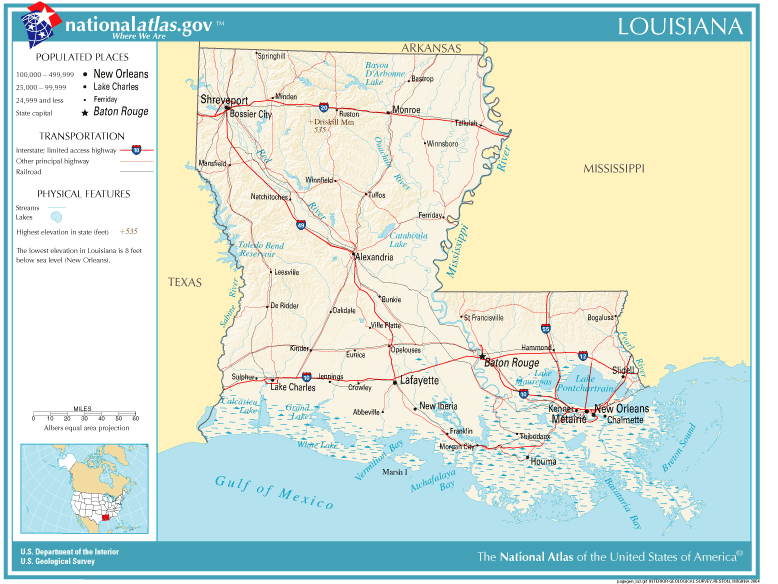
| 描述 | Louisiana map |
| 來源 | Originally from Image%3ANational-atlas-louisiana.PNG. |
| 作者 |
協議
This map was obtained from an edition of the National Atlas of the United States. Like almost all works of the U.S. federal government, works from the National Atlas are in the public domain in the United States.
Online access: NationalAtlas.gov | 1970 print edition: Library of Congress, Perry-Castañeda Library
|
Wikipedia upload log
(All user names refer to en.wikipedia)
- 2004-11-05 01:28 Queson 778×584×8 (120201 bytes) National Atlas map of Louisiana {{PD-USGov}}
檔案歷史
撳個日期/時間去睇響嗰個時間出現過嘅檔案。
| 日期/時間 | 縮圖 | 尺寸 | 用戶 | 註解 | |
|---|---|---|---|---|---|
| 現時 | 2007年5月9號 (三) 12:05 | | 778 × 584(117 KB) | Hbk33 | {{Information |Description=en:Category:Louisiana maps |Source=Originally from [http://en.wikipedia.org en.wikipedia]; description page is/was [http://en.wikipedia.org/w/index.php?title=Image%3ANational-atlas-louisiana.PNG here]. |Date=2004-11-05 (ori |
檔案用途
以下嘅1版用到呢個檔:
全域檔案使用情況
下面嘅維基都用緊呢個檔案:
- ar.wikipedia.org嘅使用情況
- en.wikivoyage.org嘅使用情況
- eu.wikipedia.org嘅使用情況
- fr.wikipedia.org嘅使用情況
- gu.wikipedia.org嘅使用情況
- he.wikipedia.org嘅使用情況
- hr.wiktionary.org嘅使用情況
- ja.wikipedia.org嘅使用情況
- kn.wikipedia.org嘅使用情況
- nl.wikipedia.org嘅使用情況
- pam.wikipedia.org嘅使用情況
- pl.wikivoyage.org嘅使用情況
- ro.wikipedia.org嘅使用情況
- sw.wikipedia.org嘅使用情況
- tr.wikipedia.org嘅使用情況