
File:Obere Schleuse in Thun.webm
呢個「WEBM」檔案嘅呢個「JPG」預覽嘅大細:800 × 450 像素。 第啲解像度:320 × 180 像素|640 × 360 像素|1,024 × 576 像素|1,280 × 720 像素|1,920 × 1,080 像素。
原本檔案 (WebM audio/video file, VP9/Opus, length 13 s, 1,920 × 1,080 pixels, 75.55 Mbps overall, file size: 114.46 MB)
摘要
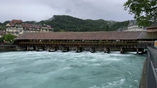
| 描述 | Die Obere Schleuse in Thun. Aufgenommen am Vormittag des 13. Juli 2021, kurz vor dem Eintritt des Hochwassers 2021. |
| 日期 | |
| 來源 | 自己作品 |
| 作者 | Nachtbold |
| Object location | | View this and other nearby images on: OpenStreetMap |
|---|
協議
| This file is made available under the Creative Commons CC0 1.0 Universal Public Domain Dedication. | |
| The person who associated a work with this deed has dedicated the work to the public domain by waiving all of their rights to the work worldwide under copyright law, including all related and neighboring rights, to the extent allowed by law. You can copy, modify, distribute and perform the work, even for commercial purposes, all without asking permission.
|
檔案歷史
撳個日期/時間去睇響嗰個時間出現過嘅檔案。
| 日期/時間 | 縮圖 | 尺寸 | 用戶 | 註解 | |
|---|---|---|---|---|---|
| 現時 | 2021年7月13號 (二) 15:35 | 13 s, 1,920 × 1,080(114.46 MB) | Nachtbold | Imported media from uploads:9f54f42e-e3e5-11eb-8570-e263f171fcab |
檔案用途
以下嘅1版用到呢個檔:
全域檔案使用情況
下面嘅維基都用緊呢個檔案:
- de.wikipedia.org嘅使用情況
- en.wikipedia.org嘅使用情況
- es.wikipedia.org嘅使用情況
- fr.wikipedia.org嘅使用情況
- ga.wikipedia.org嘅使用情況
- mk.wikipedia.org嘅使用情況
- ro.wikipedia.org嘅使用情況
- sq.wikipedia.org嘅使用情況