
File:OttomanEmpireIn1683-zh-classical.png
原本檔案 (1,966 × 1,850 像素,檔案大細:442 KB ,MIME類型:image/png)
摘要
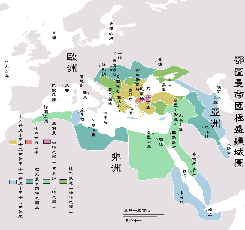
| 描述 | Map depicting the Ottoman Empire at its greatest extent, in 1683. |
| 日期 | |
| 來源 | Self drawn, mainly based on Robert Mantran (ed.), Histoire de l'Empire Ottoman, Paris: Fayard (1989), also en:List of Ottoman Empire dominated territories, Image:Ottoman 1683.png, [1], and [2]. Background map modified from Image:A large blank world map with oceans marked in blue.svg. |
| 作者 | Atilim Gunes Baydin |
| 許可 (重用呢個檔案) |
Permission is given for anyone to use this for any possible purpose. |
| Other versions |
[]
|


![[1]](http://fs.huntingdon.edu/jlewis/Syl/IRcomp/Maps/OttomanMap.jpg)
![[2]](http://www.morainevalley.edu/ctl/MiddleEast/images/Map_Ottoman_Empire_expansion_EB.jpg)
Originally picture was uploaded to here.
The Classical Chinese Modification is made by User:Itsmine.
協議
| |
This work has been released into the public domain by its author, AtilimGunesBaydin, at the 英文 維基百科 project. This applies worldwide. In case this is not legally possible: |
檔案歷史
撳個日期/時間去睇響嗰個時間出現過嘅檔案。
| 日期/時間 | 縮圖 | 尺寸 | 用戶 | 註解 | |
|---|---|---|---|---|---|
| 現時 | 2007年5月11號 (五) 06:44 |  | 1,966 × 1,850(442 KB) | Itsmine | |
| 2007年5月10號 (四) 05:31 |  | 1,966 × 1,850(438 KB) | Itsmine | ||
| 2007年5月10號 (四) 05:28 |  | 1,966 × 1,850(438 KB) | Itsmine | ||
| 2007年5月9號 (三) 14:10 |  | 1,966 × 1,850(439 KB) | Itsmine | ||
| 2007年5月9號 (三) 14:01 |  | 1,966 × 1,850(439 KB) | Itsmine | {{Information |Description=Map depicting the Ottoman Empire at its greatest extent, in 1683. |Source=Self drawn, mainly based on ''Robert Mantran (ed.), Histoire de l'Empire Ottoman, Paris: Fayard (1989)'', also [[:en:List of Ottoma |
檔案用途
以下嘅1版用到呢個檔:
全域檔案使用情況
下面嘅維基都用緊呢個檔案:
- vi.wikipedia.org嘅使用情況
- zh-classical.wikipedia.org嘅使用情況
- zh.wikipedia.org嘅使用情況