
File:Pak Kok fields1.jpg

預覽大細:800 × 542 像素。 第啲解像度:320 × 217 像素|640 × 434 像素|1,024 × 694 像素|1,172 × 794 像素。
原本檔案 (1,172 × 794 像素,檔案大細:1.3 MB ,MIME類型:image/jpeg)
摘要
| Camera location | | View this and other nearby images on: OpenStreetMap |
|---|
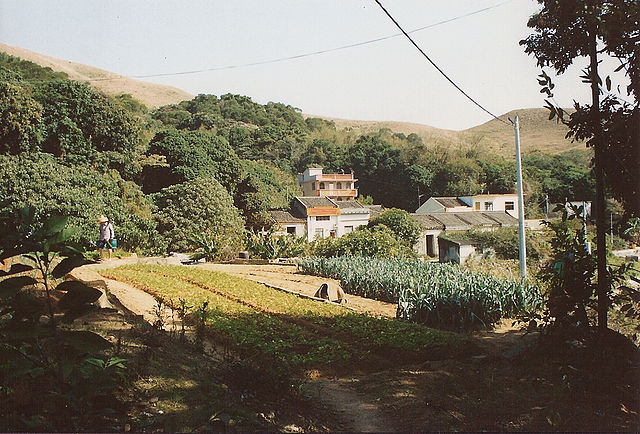
| 描述 | Pak Kok on Lamma Island, Hong Kong. The village lies in a little valley between the hills and the sea (Lamma Channel), and in 1992/3 consisted of clumps of houses dotted among the fields, occupied by a mix of commuters and farmers. A farmer carries water for his market garden crops and a typical bamboo basket for taking them to market lies on its side in the field. Overhead, electricity and telephone lines drape casually. The houses at the bottom of the valley, some of which are derelict, make up Pak Kok Kau Tsuen (old village): a typical new three-storey house can be seen slightly higher up. View facing south, taken 1992/3 on Fuju film. |
| 日期 | |
| 來源 | 自己作品 |
| 作者 | JackyR |
| 許可 (重用呢個檔案) |
as below |
Other search terms
China, agriculture, hill, tree, pole, roof, bamboo basket
See also
協議
I, the copyright holder of this work, hereby publish it under the following licenses:

|
根據自由軟體基金會發佈嘅無固定段落、封面文字同封底文字GNU自由文件授權條款第1.2或打後嘅版本,你獲授權可以重製、散佈同埋修改爾份文件。授權條款嘅副本喺章節GNU自由文件授權條款。 |
| 呢個檔案用共享創意 姓名標示-非商業性-相同方式分享3.0 未本地化版本條款授權。 | ||
| ||
| This licensing tag was added to this file as part of the GFDL licensing update. |
This file is licensed under the Creative Commons Attribution-Share Alike 2.5 Generic, 2.0 Generic and 1.0 Generic license.
- 你可以:
- 去分享 – 複製、發佈同傳播呢個作品
- 再改 – 創作演繹作品
- 要遵照下面嘅條件:
- 署名 – 你一定要畀合適嘅表彰、畀返指向呢個授權條款嘅連結,同埋寫明有無改過嚟。你可以用任何合理方式去做,但唔可以用任何方式暗示授權人認可咗你或者你嘅使用方式。
- 相同方式分享 – 如果你用任何方式改過呢個作品,你必須要用返原本或者相似嘅條款發佈。
你可以揀你想用嘅牌照。
檔案歷史
撳個日期/時間去睇響嗰個時間出現過嘅檔案。
| 日期/時間 | 縮圖 | 尺寸 | 用戶 | 註解 | |
|---|---|---|---|---|---|
| 現時 | 2006年9月11號 (一) 00:10 | | 1,172 × 794(1.3 MB) | JackyR~commonswiki | {{Information |Description=Pak Kok Tsuen (village) on Lamma Island, Hong Kong. In 1992/3 the village consisted of clumps of houses dotted among the fields, occupied by a mix of commuters and farmers. |Source=self-made |Date=2006-10-11 |Author |
檔案用途
以下嘅3版用到呢個檔:
全域檔案使用情況
下面嘅維基都用緊呢個檔案:
- en.wikipedia.org嘅使用情況
- zh.wikipedia.org嘅使用情況