
File:Rodrigues Island topographic-zones map-fr.svg

呢個「SVG」檔案嘅呢個「PNG」預覽嘅大細:637 × 600 像素。 第啲解像度:255 × 240 像素|510 × 480 像素|816 × 768 像素|1,088 × 1,024 像素|2,176 × 2,048 像素|1,700 × 1,600 像素。
原本檔案 (SVG檔案,表面大細: 1,700 × 1,600 像素,檔案大細:989 KB)

| 描述 |
Deutsch: Zonenkarte der Insel Rodrigues
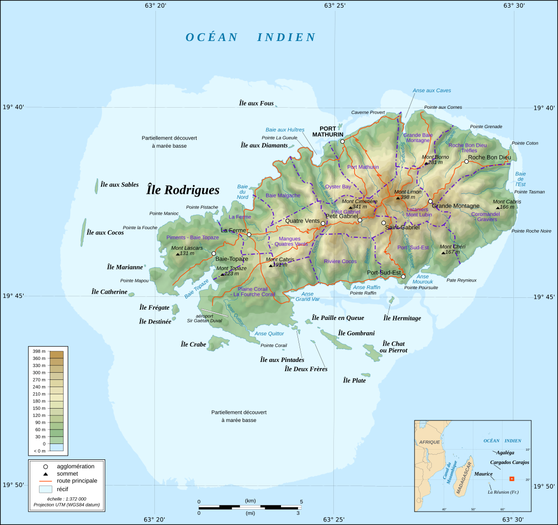
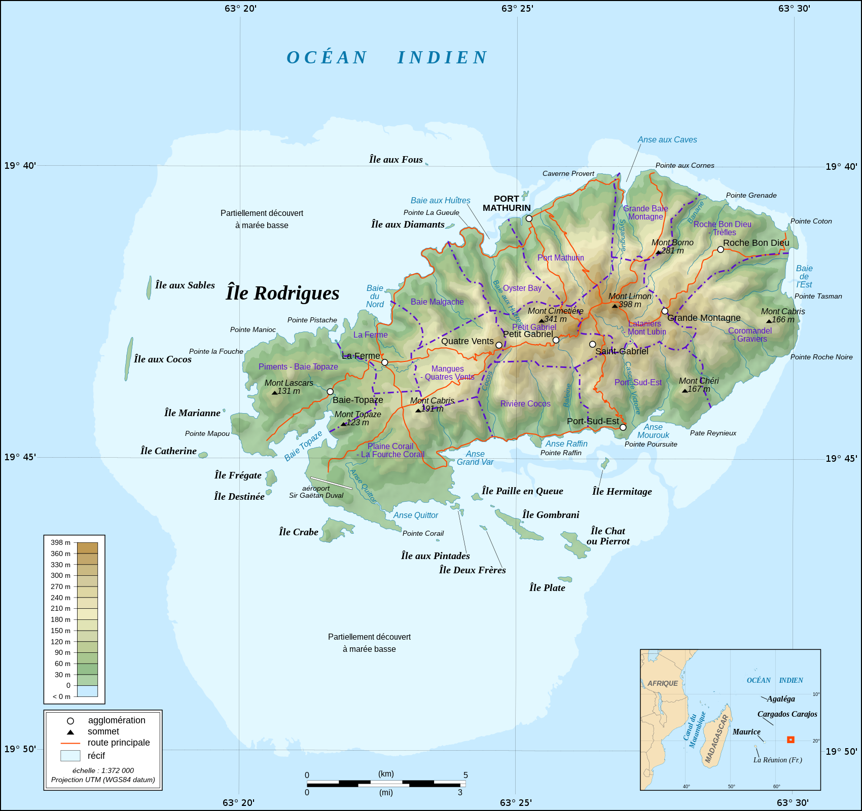
English: Topographic map in French of Rodrigues Island, Mauritius Scale : 1:372,000 (accuracy : about 93 m) ; Printing size : 7.79 x 7.33 cm ; Note : The background map is a raster image embedded in the SVG file. Français : Carte topographique en français de l'île de Rodrigues, Maurice ; UTM projection ; WGS84 datum ; shaded relief (composite image of N-W, W and N lightning positions) ;Échelle : 1:372 000 (précision : environ 93 m) ; Taille d'impression : 7,79 x 7,33 cm ; Note : Le fond de carte est une image bitmap embarquée dans le fichier SVG. Geographic limits of the map: *West : 63° 15' 34.66" E *East : 63° 31' 14.68" E *North : 19° 37' 09.97" S *South : 19° 51' 02.05" S |
| 日期 | (UTC) |
| 來源 | |
| 作者 |
|
| Other versions |
Derivative works of this file: |
| This is a retouched picture, which means that it has been digitally altered from its original version. Modifications: fusion des 2 cartes. The original can be viewed here: Rodrigues Island topographic map-fr.svg:
|
呢個檔案用共享創意 姓名標示-非商業性-相同方式分享3.0 未本地化版本條款授權。
- 你可以:
- 去分享 – 複製、發佈同傳播呢個作品
- 再改 – 創作演繹作品
- 要遵照下面嘅條件:
- 署名 – 你一定要畀合適嘅表彰、畀返指向呢個授權條款嘅連結,同埋寫明有無改過嚟。你可以用任何合理方式去做,但唔可以用任何方式暗示授權人認可咗你或者你嘅使用方式。
- 相同方式分享 – 如果你用任何方式改過呢個作品,你必須要用返原本或者相似嘅條款發佈。
Original upload log
This image is a derivative work of the following images:
- File:Rodrigues_Zonenkarte_de.png licensed with Cc-by-sa-3.0
- 2010-03-02T14:15:57Z Vuxi 1284x1209 (562056 Bytes) + Schriftzug
- 2010-03-01T21:56:33Z Vuxi 1284x1209 (558361 Bytes) einige Orte
- 2010-02-27T21:36:06Z Vuxi 1284x1209 (552183 Bytes) + Namen der Zonen + Orte - Berge
- 2010-02-26T10:45:31Z Vuxi 1284x1209 (536481 Bytes) {{Information |Description={{de|1=Zonenkarte der Insel Rodrigues}} |Source={{own}} |Author=[[User:Vuxi|Vuxi]] |Date= |Permission= |other_versions= }} topographic map:[[:File:Rodrigues Island topographic map-de.svg]], borders:
- File:Rodrigues_Island_topographic_map-fr.svg licensed with Cc-by-sa-3.0,2.5,2.0,1.0, GFDL
- 2008-09-06T02:29:37Z Sting 1700x1600 (1025524 Bytes) Adding roads and other labels ; new standard colors
- 2008-05-14T03:46:05Z Sting 1700x1600 (782832 Bytes) == Summary == {{Location|19|43|00|S|63|25|00|E|scale:200000}} {{Information |Description={{en|Topographic map in French of [[:en:Rodrigues (island)|Rodrigues Island]], [[:en:Mauritius|Mauritius]]}} {{fr|Carte topographique e
Uploaded with derivativeFX
檔案歷史
撳個日期/時間去睇響嗰個時間出現過嘅檔案。
| 日期/時間 | 縮圖 | 尺寸 | 用戶 | 註解 | |
|---|---|---|---|---|---|
| 現時 | 2022年6月25號 (六) 00:36 | | 1,700 × 1,600(989 KB) | Blua lago | File uploaded using svgtranslate tool (https://svgtranslate.toolforge.org/). Added translation for hu. |
| 2010年8月11號 (三) 08:27 |  | 1,700 × 1,600(970 KB) | M0tty | {{Information |Description={{de|1=Zonenkarte der Insel Rodrigues}} {{en|Topographic map in French of Rodrigues Island, Mauritius<br/>Scale : 1:372,000 (accuracy : about 93 m) ; Printing size : 7.79 x 7.33 cm ;< |
檔案用途
以下嘅1版用到呢個檔:
全域檔案使用情況
下面嘅維基都用緊呢個檔案:
- fr.wikipedia.org嘅使用情況
- nl.wikipedia.org嘅使用情況
- simple.wikipedia.org嘅使用情況
- uk.wikipedia.org嘅使用情況