
File:SafsafOasis SAR comparison.jpg
冇更高解像度嘅圖像。
SafsafOasis_SAR_comparison.jpg (540 × 588 像素,檔案大細:154 KB ,MIME類型:image/jpeg)
摘要
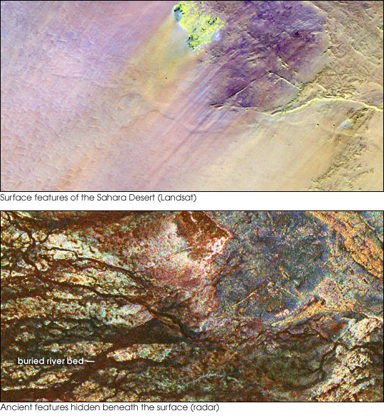
| 描述 | Two images of the Safsaf Oasis in The Sahara. The top image (taken by the Landat Thematic Mapper) is the surface. The bottom (taken by the Spaceborne Imaging Radar-C/X-band Synthetic Aperture Radar (SIR-C/X-SAR) on board the Space Shuttle Endeavour on April 16, 1994) is the rock layer underneath, revealing black channels cut by the meandering of an ancient river. |
| 日期 | not specified |
| 來源 | http://earthobservatory.nasa.gov/Newsroom/NewImages/images.php3?img_id=16963 |
| 作者 | NASA/JPL Imaging Radar team. |
| 許可 (重用呢個檔案) |
Public domain |
| Other versions |
|


協議
| This file is in the public domain in the United States because it was solely created by NASA. NASA copyright policy states that "NASA material is not protected by copyright unless noted". (See Template:PD-USGov, NASA copyright policy page or JPL Image Use Policy.) | ||
 |
Warnings:
|
檔案歷史
撳個日期/時間去睇響嗰個時間出現過嘅檔案。
| 日期/時間 | 縮圖 | 尺寸 | 用戶 | 註解 | |
|---|---|---|---|---|---|
| 現時 | 2006年5月9號 (二) 15:55 | | 540 × 588(154 KB) | Holly Cheng | {{Information | Description=Two images of the Safsaf Oasis in the Sahara. The top image (taken by the Landat Thematic Mapper) is the surface. The bottom (taken by the Spaceborne Imaging Radar-C/X-band Synthetic Aperture Radar (SIR-C/X-SAR) on board the Sp |
檔案用途
以下嘅1版用到呢個檔:
全域檔案使用情況
下面嘅維基都用緊呢個檔案:
- es.wikipedia.org嘅使用情況
- eu.wikipedia.org嘅使用情況
- la.wikipedia.org嘅使用情況
- nds-nl.wikipedia.org嘅使用情況
- rw.wikipedia.org嘅使用情況
- sw.wikipedia.org嘅使用情況
- vi.wikipedia.org嘅使用情況