
File:Scotia Sea.png

預覽大細:600 × 600 像素。 第啲解像度:240 × 240 像素|480 × 480 像素|726 × 726 像素。
原本檔案 (726 × 726 像素,檔案大細:10 KB ,MIME類型:image/png)
摘要
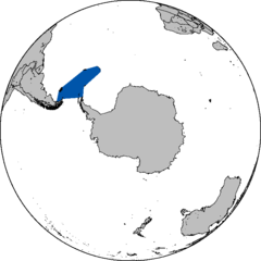
| 描述 | This map shows the approximate area of the Scotia Sea, based on the description in its article. I created it using Image:Blankmap-ao-090S-south pole.png and GraphicConverter. |
| 日期 | 2006年8月28號 (original upload date) |
| 來源 | No machine-readable source provided. Own work assumed (based on copyright claims). |
| 作者 | No machine-readable author provided. Foobaz assumed (based on copyright claims). |
協議
| I, the copyright holder of this work, release this work into the public domain. This applies worldwide. In some countries this may not be legally possible; if so: I grant anyone the right to use this work for any purpose, without any conditions, unless such conditions are required by law. |
檔案歷史
撳個日期/時間去睇響嗰個時間出現過嘅檔案。
| 日期/時間 | 縮圖 | 尺寸 | 用戶 | 註解 | |
|---|---|---|---|---|---|
| 現時 | 2006年8月28號 (一) 18:02 | | 726 × 726(10 KB) | Foobaz | This map shows the approximate area of the w:Scotia Sea, based on the description in its article. I created it using Image:Blankmap-ao-090S-south pole.png and w:GraphicConverter. |
檔案用途
以下嘅1版用到呢個檔:
全域檔案使用情況
下面嘅維基都用緊呢個檔案:
- af.wikipedia.org嘅使用情況
- an.wikipedia.org嘅使用情況
- az.wikipedia.org嘅使用情況
- ba.wikipedia.org嘅使用情況
- be.wikipedia.org嘅使用情況
- bn.wikipedia.org嘅使用情況
- bs.wikipedia.org嘅使用情況
- ca.wikipedia.org嘅使用情況
- ce.wikipedia.org嘅使用情況
- cs.wikipedia.org嘅使用情況
- cv.wikipedia.org嘅使用情況
- da.wikipedia.org嘅使用情況
- de.wikipedia.org嘅使用情況
- el.wikipedia.org嘅使用情況
- en.wikipedia.org嘅使用情況
- eo.wikipedia.org嘅使用情況
- es.wikipedia.org嘅使用情況
- fa.wikipedia.org嘅使用情況
- fr.wikipedia.org嘅使用情況
- fy.wikipedia.org嘅使用情況
- gl.wikipedia.org嘅使用情況
- he.wikipedia.org嘅使用情況
- id.wikipedia.org嘅使用情況
- it.wikipedia.org嘅使用情況
- ja.wikipedia.org嘅使用情況
- ko.wikipedia.org嘅使用情況
- la.wikipedia.org嘅使用情況
- lt.wikipedia.org嘅使用情況
- mk.wikipedia.org嘅使用情況
- ml.wikipedia.org嘅使用情況
- nn.wikipedia.org嘅使用情況
- no.wikipedia.org嘅使用情況
- pnb.wikipedia.org嘅使用情況
- pt.wikipedia.org嘅使用情況
- ru.wikipedia.org嘅使用情況
- sc.wikipedia.org嘅使用情況
- sh.wikipedia.org嘅使用情況
- simple.wikipedia.org嘅使用情況
- sl.wikipedia.org嘅使用情況
- sr.wikipedia.org嘅使用情況
- sv.wikipedia.org嘅使用情況
- sw.wikipedia.org嘅使用情況
睇呢個檔案嘅更多全域使用情況。