
File:Spratly with flags.jpg
原本檔案 (962 × 741 像素,檔案大細:94 KB ,MIME類型:image/jpeg)

|
This locator map image could be recreated using vector graphics as an SVG file. This has several advantages; see Commons:Media for cleanup for more information. If an SVG form of this image is already available, please upload it. After uploading an SVG, replace this template with {{vector version available|new image name.svg}}.
|


| 描述 |
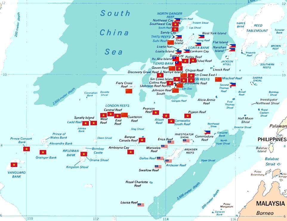
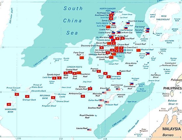
Spratly islands map showing occupied features marked with the flags of countries occupying them.
Kennan Reef (C) The flag nearest the flag for Johnson South Reef (C). |
||||||
| 日期 | (Original Picture), February 3, 2008 (Modified Picture) | ||||||
| 來源 | Central Intelligence Agency. | ||||||
| 作者 | CIA. Cropped and Flags added by Estarapapax. | ||||||
| 許可 (重用呢個檔案) |
|
||||||

檔案歷史
撳個日期/時間去睇響嗰個時間出現過嘅檔案。
| 日期/時間 | 縮圖 | 尺寸 | 用戶 | 註解 | |
|---|---|---|---|---|---|
| 現時 | 2008年3月25號 (二) 05:38 | | 962 × 741(94 KB) | KAVO | {{Information |Description=Spratly islands map showing occupied features marked with the flags of countries occupying them. <br>{{flagicon|Philippines}} Philippines <br>{{flagicon|Taiwan}} Taiwan <br>{{flagicon|Vietnam}} Vietnam <br>{{flagicon|Malaysia}} |
檔案用途
以下嘅1版用到呢個檔:
全域檔案使用情況
下面嘅維基都用緊呢個檔案:
- az.wikipedia.org嘅使用情況
- bg.wikipedia.org嘅使用情況
- ceb.wikipedia.org嘅使用情況
- cs.wikipedia.org嘅使用情況
- da.wikipedia.org嘅使用情況
- de.wikipedia.org嘅使用情況
- en.wikipedia.org嘅使用情況
- es.wikipedia.org嘅使用情況
- et.wikipedia.org嘅使用情況
- fr.wikipedia.org嘅使用情況
- hi.wikipedia.org嘅使用情況
- id.wikipedia.org嘅使用情況
- ja.wikipedia.org嘅使用情況
睇呢個檔案嘅更多全域使用情況。