
File:Strait of Dover map.png

預覽大細:798 × 599 像素。 第啲解像度:320 × 240 像素|639 × 480 像素|1,000 × 751 像素。
原本檔案 (1,000 × 751 像素,檔案大細:187 KB ,MIME類型:image/png)
摘要
| 描述 |
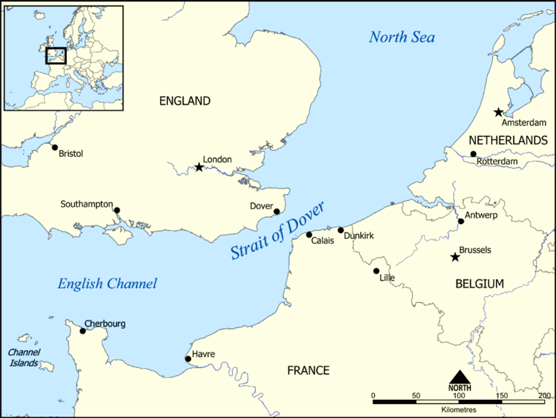
This map shows the location of the Strait of Dover between England and France, and part of the English Channel and the North Sea. It also shows nearby towns such as Dover, Calais, and Dunkirk. Created by NormanEinstein, December 15, 2005. |
| 日期 | 2005年12月15號 (original upload date) |
| 來源 | No machine-readable source provided. Own work assumed (based on copyright claims). |
| 作者 | No machine-readable author provided. NormanEinstein assumed (based on copyright claims). |
協議
I, the copyright holder of this work, hereby publish it under the following licenses:

|
根據自由軟體基金會發佈嘅無固定段落、封面文字同封底文字GNU自由文件授權條款第1.2或打後嘅版本,你獲授權可以重製、散佈同埋修改爾份文件。授權條款嘅副本喺章節GNU自由文件授權條款。 |
| 呢個檔案用共享創意 姓名標示-非商業性-相同方式分享3.0 未本地化版本條款授權。 | ||
| ||
| This licensing tag was added to this file as part of the GFDL licensing update. |
你可以揀你想用嘅牌照。
Derivative works
-
 hrvatski (SVG)
 -
 македонски (SVG)
 -
 English (PNG), showing evacuation routes of the Dunkirk evacuation


| Annotations | This image is annotated: View the annotations at Commons |
檔案歷史
撳個日期/時間去睇響嗰個時間出現過嘅檔案。
| 日期/時間 | 縮圖 | 尺寸 | 用戶 | 註解 | |
|---|---|---|---|---|---|
| 現時 | 2014年6月13號 (五) 19:17 | | 1,000 × 751(187 KB) | Hohum | Adjust colours |
| 2005年12月15號 (四) 15:34 |  | 1,000 × 751(296 KB) | NormanEinstein | This map shows the location of the Strait of Dover between England and France, and part of the English Channel and the North Sea. It also shows nearby towns such as Dover, Calais, and Dunkirk. Created by NormanEinstein, December 15, 2005. {{GFDL-self}} |
檔案用途
以下嘅1版用到呢個檔:
全域檔案使用情況
下面嘅維基都用緊呢個檔案:
- af.wikipedia.org嘅使用情況
- an.wikipedia.org嘅使用情況
- ar.wikipedia.org嘅使用情況
- ba.wikipedia.org嘅使用情況
- be-tarask.wikipedia.org嘅使用情況
- be.wikipedia.org嘅使用情況
- bg.wikipedia.org嘅使用情況
- bh.wikipedia.org嘅使用情況
- bn.wikipedia.org嘅使用情況
- br.wikipedia.org嘅使用情況
- da.wikipedia.org嘅使用情況
- de.wikipedia.org嘅使用情況
- el.wikipedia.org嘅使用情況
- en.wikipedia.org嘅使用情況
- en.wikibooks.org嘅使用情況
- fa.wikipedia.org嘅使用情況
- fi.wikipedia.org嘅使用情況
- fr.wikipedia.org嘅使用情況
- fy.wikipedia.org嘅使用情況
- gl.wikipedia.org嘅使用情況
- hu.wikipedia.org嘅使用情況
- id.wikipedia.org嘅使用情況
- it.wikipedia.org嘅使用情況
- ja.wikipedia.org嘅使用情況
- la.wikipedia.org嘅使用情況
- mr.wikipedia.org嘅使用情況
- ms.wikipedia.org嘅使用情況
- nn.wikipedia.org嘅使用情況
- no.wikipedia.org嘅使用情況
- pt.wikipedia.org嘅使用情況
- ro.wikipedia.org嘅使用情況
- simple.wikipedia.org嘅使用情況
睇呢個檔案嘅更多全域使用情況。